
The Central Provinces and Berar was a province of British India and later the Dominion of India which existed from 1903 to 1950. It was formed by the merger of the Central Provinces with the province of Berar, which was territory leased by the British from the Hyderabad State. Through an agreement signed on 5 November 1902, 6th Nizam Mahbub Ali Khan, Asaf Jah VI leased Berar permanently to the British for an annual payment of 25 lakhs rupees. Lord Curzon decided to merge Berar with the Central Provinces, and this was proclaimed on 17 September 1903.
Yavatmal district, [jəʋət̪maːɭ] formerly known as Yeotmal, is a district of the Indian state of Maharashtra. It is located in the region of Vidarbha, in the east-central part of the state. It is Vidarbha's third-largest district by population, after Nagpur and Amravati. Yavatmal city is the administrative headquarters of the district.

Berar Province, also known as the Hyderabad Assigned Districts, was a province of Hyderabad. After 1853, it was administered by the British, although the Nizam retained formal sovereignty over the province. Azam Jah, the eldest son of the 7th Nizam, held the title of Mirza-Baig ("Prince") of Berar.
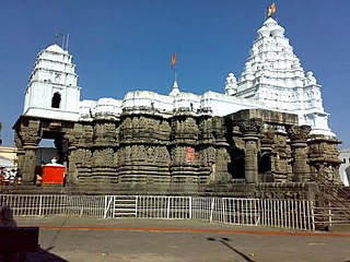
Hingoli district is an administrative district in the state of Maharashtra in India. The district is headquartered at Hingoli. The district occupies an area of 4,526 km2 and has a population of 11,77,345 of which 15.60% were urban. Hingoli was actually known as the Nizams military base as it was bordered with Vidharbha. In that era military troops, hospitals, veterinary hospital were in operation from Hingoli. Being a military base the city was one of the important and famous places of the Hyderabad state. One of the twelve Jyotirlinga shrines, the Aundha Nagnath is located in Hingoli district about 25 km south-west from district headquarter.

Amravati district is a district of Maharashtra state in central India. It is the administrative headquarter of Amravati division, which is one of the two divisions in Vidarbha, out of total 6 regions in state of Maharashtra.
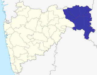
The Nagpur Division is one of six administrative divisions of the state of Maharashtra in India. Nagpur is the easternmost division in the state, with an administrative headquarters in the city of Nagpur. It covers 51,336 km² (19,821 mi²). The Amravati and Nagpur divisions make up the Vidarbha region.

Amravati Division, also known as Varhad, is an Indian one of the six administrative divisions of Maharashtra state in India. Amravati and Nagpur divisions constitute the ancient Vidarbha region. Amravati Division is bound by Madhya Pradesh state to the north, Nagpur Division to the east, Telangana state to the southeast, Marathwada region to the south and southwest, and Nashik Division to the west.

Achalpur, formerly known as Ellichpur and Illychpur, is a city and a municipal council in Amravati District in the Indian state of Maharashtra. It is the second most populous city in Amravati District after Amravati and seventh most populous city in Vidarbha. Achalpur camp is known as Paratwada.
Daryapur is a city located in the Amravati District of Maharashtra State, India. It belongs to the Vidarbha region of the Amravati Division. It is located 52 km (32.31m) west of the District headquarters of Amravati.
Paratwada, formerly known as Paltanwada and also known as "Achalpur Camp" is a city and a municipal council in Amravati District in the Indian state of Maharashtra. It is also the second most populous city in Amravati District after Amravati and seventh most populous city in Vidarbha. It has a twin city known as Achalpur. Paratwada is a gateway to the Melghat region which has one of the biggest Tiger conservation projects in India.
Chhattisgarh Division was an administrative division of the Central Provinces of British India. It was located in the east of the Central Provinces and encompassed the upper Mahanadi River basin, in the central part of present-day Chhattisgarh state of India.

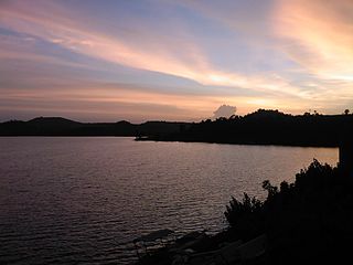
Melghat was among the first nine tiger reserves of India to be notified in 1973 under Project Tiger. It is located at 21°26′45″N77°11′50″E in the northern part of Amravati District of Maharashtra. Melghat Wildlife Sanctuary was declared as in 1985. The Tapti River flows through the northern part of Melghat Tiger Reserve and forms the boundary of the reserve together with the Gawilghur ridge of the Satpura Range.
The Berar Division, formerly Berar Province, was one of the former administrative divisions of the Central Provinces and Berar of British India. Ellichpur (Achalpur) was the capital and the administrative headquarters of the division.
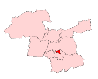
Amravati Assembly constituency is one of the 288 constituencies of Maharashtra Vidhan Sabha and one of the eight which are located in the Amravati district.

Achalpur Assembly constituency is one of the 288 constituencies of Maharashtra Vidhan Sabha and one of the eight which are located in Amravati district.

Teosa Assembly constituency is one of the 288 constituencies of Maharashtra Vidhan Sabha and one of the eight present in Amravati district.

Badnera is one of the 288 constituencies of Maharashtra Vidhan Sabha and one of the eight which are located in Amravati district.

Daryapur Assembly constituency is one of the 288 constituencies of Maharashtra Vidhan Sabha and one of the eight which are located in Amravati district. It is reserved for Scheduled Caste candidates.

Melghat Assembly constituency is one of the 288 constituencies of Maharashtra Vidhan Sabha and one of the eight which are located in the Amravati district. It is reserved for Scheduled Tribe candidate.
Coimbatore District was one of the districts of the erstwhile Madras Presidency of British India. It covered the areas of the present-day districts of Coimbatore, Erode and Tirupur and the Kollegal taluk of present-day Karnataka. It covered a total area of 20,400 square kilometres (7,860 sq mi) and was sub-divided into 10 taluks. The administrative headquarters was Coimbatore city. Most of Coimbatore's inhabitants were Tamil-speaking but there were also large numbers of Malayalam, Telugu and Kannada speaking people.

