Singhbhum district

Last updated

Singhbhum District
District of the Bengal Presidency
1820–1947
British Raj Red Ensign.svg
Flag
Singhbum-Sairakela-Kharsawan.jpg
Singhbhum district in a 1909 map of The Imperial Gazetteer of India
Capital Chaibasa
Area 
 1901
10,078 km2 (3,891 sq mi)
Population 
 1872
318,180
 1881
453,775
 1891
545,488
 1901
613,579
 1931
929,802
History 
 The Raja of Singhbhum becomes a feudatory of the British
1820
1947
 Bifurcation
1990
Succeeded by
East Singhbhum Flag of India.svg
West Singhbhum Flag of India.svg

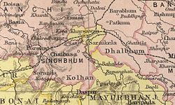
Singhbhum was a district of India during the British Raj, part of the Chota Nagpur Division of the Bengal Presidency. [1] It was located in the present-day Indian state of Jharkhand. Chaibasa was the district headquarters. Located in the southern limit of the Chota Nagpur Plateau, Singhbhum included the Kolhan estate located in its southeastern part. [2] The district has been segmented into two smaller districts, East Singhbhum and West Singhbhum.

Contents

Etymology

Singhbhum is a portmanteau of Singh and Bhum. "Singh" refers to the Singh raja of the greater Porahat state, and "Bhum" signifies the land, thereby forming the land of Singh. [3] Manbhum, Barabhum, Dhalbhum, Bhanjbhum and other nearby areas follow similar nomenclature. However, the prominent inhabitants Ho tribe asserts that Singhbhum derives its name from 'Singbonga,' the supreme god of the Adivasis in the region, primarily venerated by the Kolarian ethnic tribes. [4]

Geography

It is bounded with Ranchi District in the north, with the Saraikela and Kharsawan princely states in the east, with Mayurbhanj and Keonjhar in the south as well as with Bonai and Gangpur in the southwest. [2] Singhbhum District had an area of 10,078 square kilometres (3,891 sq mi) and a population of 613,579 in 1901. [5]

History

The Singhbhum area was never invaded by either the Marathas or the Mughals. The first relationships between the Raja of Singhbhum and the British were established in 1767 when he approached the Resident at Midnapore requesting protection. In 1820 the Raja became a feudatory of the British. The state was under the political control of the Commissioner of the Bengal Presidency until 1912, [2] under the Bihar and Orissa Province until 1936 and then under Chhota Nagpur Division until the end of the British Raj.

Singhbhum on James Rennell's Mid-18th Century map Mayurbhanj Midnapore border 1776.jpg
Singhbhum on James Rennell's Mid-18th Century map
Bihar and Orissa in a 1912 map of British India Bihar and Orissa province.jpg
Bihar and Orissa in a 1912 map of British India

Following the independence of India Singhbhum district became part of the Indian Union as a district of Bihar. In 1990, for administrative convenience, the district was divided into two districts: East Singhbhum and West Singhbhum. In 2000, South Bihar separated from North Bihar to form the state of Jharkhand. Subsequently, in 2001, the princely state of Saraikela and Kharsawan was bifurcated from East Singhbhum district to form Saraikela Kharsawan district of Jharkhand.

Demographics

Historical population
YearPop.±%
1901754,658    
1911843,040+11.7%
1921911,935+8.2%
19311,116,424+22.4%
19411,350,141+20.9%
19511,480,816+9.7%
1961    
19712,437,799    
1981    
Post the 1981 census, the district bifurcated into East and West Singhbhum districts.
Note: The census data exhibit discrepancies owing to changes in administration within specific regions of Singhbhum.
Source: Census of India [6]

According to the 1931 census, the total population of Singhbhum (including Dhalbhum) was 929,802. The predominant communities in the region were the Ho, comprising 32.39% of the population, followed by the Santal at 11.71%, Bhumij at 5.71%, Munda at 5.48%, Gaura at 5.04%, Tanti at 4.09%, Goala at 3.79%, Hajjam at 2.68%, Kurmi at 2.42%, Bhuiyan at 1.97%, Kamar at 1.87%, Brahman at 1.71%, Kumhar at 1.49%, Rajput at 1.4%, Teli at 1.31%, Oraon at 1.09%, Kayastha at 1.04%, and others such as Kewat, Gadaba, Dhobi, Kharia, Bania, Dom, Mahli, Chamar, Khandait, Hari, Kahar, Jolaha, Mallah, Karmali, Bathudi, Karan, Savar, Korwa, Mochi, and Birhor. [7]

Language of Singhbhum district (1931) [7]

   Ho (32.83%)
   Odia (18.48%)
   Bengali (15.87%)
   Santali (11.15%)
   Hindi & Urdu (5.72%)
   Mundari (5.85%)
   Bhumij (3.25%)
   Kurukh (1.09%)
  Other (5.76%)

In terms of language, the Ho language was the most prevalent at 32.83%, followed by Odia at 18.49%, Bengali at 15.87%, Santali at 11.15%, Hindi and Urdu at 8.72%, Mundari at 5.85%, Bhumij at 3.25%, and other notable spoken languages such as Telugu, Panjabi, Tamil, Mahli, Gujurati, Nepali, Gondi, Marwari, Pashtu, and some European languages. [7]

Related Research Articles

<span class="mw-page-title-main">Jharkhand</span> State in eastern India

Jharkhand is a state in eastern India. The state shares its border with the states of West Bengal to the east, Chhattisgarh to the west, Uttar Pradesh to the northwest, Bihar to the north and Odisha to the south. It is the 15th largest state by area, and the 14th largest by population. Hindi is the official language of the state. The city of Ranchi is its capital and Dumka its sub-capital. The state is known for its waterfalls, hills and holy places; Baidyanath Dham, Parasnath, Dewri and Rajrappa are major religious sites. Jharkhand is primarily rural, with about 24% of its population living in cities.

<span class="mw-page-title-main">West Singhbhum district</span> District of Jharkhand in India

West Singhbhum or Pashchimi Singhbhum is one of the 24 districts of Jharkhand state, India. It came into existence on 16 January 1990, when the old Singhbhum district was bifurcated. Chaibasa is the district headquarters.

<span class="mw-page-title-main">Seraikela Kharsawan district</span> District of Jharkhand in India

Seraikela-Kharsawan district or Saraikella and Kharaswan district is one of the twenty-four districts of Jharkhand state in eastern India. Seraikela town is the district headquarters of Saraikela Kharsawan district. The district is well known for Seraikela Chhau, one of the three distinctive styles of the chhau dance. This district was carved out from West Singhbhum district in 2001. The district was formed from the princely states of Seraikela and Kharaswan, after the independence of India.

<span class="mw-page-title-main">Manbhum</span> East Indian district during the British Raj

Manbhum District was one of the districts of the East India during the British Raj. After India's independence, the district became a part of Bihar State. Upon the reorganization of the Indian states in the mid-1950s, the Manbhum district was partitioned based on language. The Bengal-speaking areas were included in West Bengal, while the rest were kept with Bihar.

Kharsawan garh is a town and a notified area in the Seraikela Sadar subdivision of the Seraikela Kharsawan district in the Indian state of Jharkhand.

<span class="mw-page-title-main">Chota Nagpur Division</span>

Chota Nagpur Division, also known as the South-West Frontier, was an administrative division of British India. It included most of the present-day state of Jharkhand as well as adjacent portions of West Bengal, Orissa, and Chhattisgarh.

<span class="mw-page-title-main">Chota Nagpur Tributary States</span>

The Chota Nagpur Tributary States or Chota Nagpur States were a group of non-salute states at the time of British Raj, located on the Chota Nagpur Plateau. British suzerainty over the states was exercised through the government of the Bengal Presidency.

The region have been inhabited since the Stone Age. Copper tools from the Chalcolithic period have been discovered. This area entered the Iron Age during the mid-2nd millennium BCE.

<span class="mw-page-title-main">Bhumij people</span> Ethnic group of India

Bhumij is a Munda ethnic group of India. They primarily live in the Indian states of West Bengal, Odisha, Assam and Jharkhand, mostly in the old Singhbhum district. Also in states like Bihar and Assam. There is also a sizeable population found in Bangladesh. Bhumijas speak the Bhumij language, an Austroasiatic language, and use Ol Onal script for writing.

<span class="mw-page-title-main">Saraikela State</span> Princely state of British India in modern-day Jharkhand

Saraikela State also spelt Seraikela, Saraikella or Seraikella, was a princely state in India during the era of the British Raj, in the region that is now the Jharkhand state. Its capital was at Saraikela.

<span class="mw-page-title-main">Kharsawan State</span> Princely state of the British Raj

Kharsawan State, also spelt Kharsua or kharaswan, (Odia:ଖରସୁଆଁ)was a princely state in India during the era of the British Raj. The state had a privy purse of 33,000 Rs.It was one of the Odia Princely states of India during the period of the British Raj and the major language spoken in the area is Odia.

<span class="mw-page-title-main">Bagal (caste)</span> Cattle herding caste of East India

Bagal is a cattle herding caste of East India. Bagal people are living in the state of West Bengal, Jharkhand and Odisha. They use Kudmali/ Manbhumi dialect of Bengali as mother tongue and use Bengali, Hindi and Odia language to communicate with the society.

Kuchai block is a CD block that forms an administrative division in the Seraikela Sadar subdivision of Seraikela Kharsawan district, in the Indian state of Jharkhand.

Kharsawan block is a CD block that forms an administrative division in the Seraikela Sadar subdivision of Seraikela Kharsawan district, in the Indian state of Jharkhand.

<span class="mw-page-title-main">Chandil block</span> Community development block in Jharkhand, India

Chandil block is a CD block that forms an administrative division in the Chandil subdivision of Seraikela Kharsawan district, in the Indian state of Jharkhand.

Ichagarh block is a CD block that forms an administrative division in the Chandil subdivision of Seraikela Kharsawan district, in the Indian state of Jharkhand.

Adityapur block is a CD block that forms an administrative division in the Seraikela Sadar subdivision of Seraikela Kharsawan district, in the Indian state of Jharkhand.

<span class="mw-page-title-main">Seraikela block</span> Community development block in Jharkhand, India

Seraikela block is a CD block that forms an administrative division in the Seraikela Sadar subdivision of Seraikela Kharsawan district, in the Indian state of Jharkhand.

<span class="mw-page-title-main">Gobindpur block</span> Community development block in Jharkhand, India

Gobindpur block is a CD block that forms an administrative division in the Seraikela Sadar subdivision of Seraikela Kharsawan district, in the Indian state of Jharkhand.

The Bhumij Rebellion or Bhumij Revolt, also known as Ganga Narain's Hungama was a revolt during 1832–1833 by Bhumij tribals based in the Dhalbhum and Jungle Mahal areas of the Midnapore district of the erstwhile Bengal state. It was led by Ganga Narayan Singh.

References

  1. Chisholm, Hugh, ed. (1911). "Singhbhum"  . Encyclopædia Britannica . Vol. 25 (11th ed.). Cambridge University Press. p. 148.
  2. 1 2 3 "Imperial Gazetteer2 of India, Volume 23, page 1 -- Imperial Gazetteer of India -- Digital South Asia Library". dsal.uchicago.edu. Retrieved 28 October 2022.
  3. Schulte-Droesch, Lea (10 September 2018). Making Place through Ritual: Land, Environment and Region among the Santal of Central India. Walter de Gruyter GmbH & Co KG. p. 11. ISBN   978-3-11-054085-7.
  4. Journal of Historical Research. Department of History, Ranchi University. 2003.
  5. Wilson Hunter, Sir William; Sutherland Cotton, James; Sir Richard Burn, Sir William Stevenson Meyer. Great Britain India Office. The Imperial Gazetteer of India . Oxford: Clarendon Press, 1908
  6. Prasad, Ranchar (1956). District Census Handbook Singhbhum - Census 1951 (PDF). Director of Census Operations, Bihar. pp. 3, 22.
  7. 1 2 3 Lacey, W. G. (1932). Census of India, 1931 (PDF). Vol. VII. Bihar and Orissa (Part. II. Tables). Superintendent, Government Printing. see. Table XVII & XVIII.

Bibliography

22°30′N85°30′E / 22.500°N 85.500°E / 22.500; 85.500