
The Marshall Islands, officially the Republic of the Marshall Islands, is an island country west of the International Date Line and north of the equator in the Micronesia region in the Northwestern Pacific Ocean. The territory consists of 29 coral atolls and five islands, divided across two island chains: Ratak in the east and Ralik in the west. 97.87% of its territory is water, the largest proportion of water to land of any sovereign state. The country shares maritime boundaries with Wake Island to the north, Kiribati to the southeast, Nauru to the south, and the Federated States of Micronesia to the west. The capital and largest city is Majuro, home to approximately half of the country's population.

The Marshall Islands consist of two archipelagic island chains of 30 atolls and 1,152 islands, which form two parallel groups—the "Ratak" (sunrise) chain and the "Ralik" (sunset) chain. The Marshalls are located in the North Pacific Ocean and share maritime boundaries with Micronesia and Kiribati. Two-thirds of the nation's population lives in the capital of Majuro and the settlement of Ebeye. The outer islands are sparsely populated due to lack of employment opportunities and economic development.
Austronesian settlers arrived in the Marshall Islands in the 2nd millennium BC, but there are no historical or oral records of that period. Over time, the Marshallese people learned to navigate over long ocean distances by walap canoe using traditional stick charts.
Kwajalein Atoll is part of the Republic of the Marshall Islands (RMI). The southernmost and largest island in the atoll is named Kwajalein Island, which its majority English-speaking residents often use the shortened name, Kwaj. The total land area of the atoll amounts to just over 6 square miles (16 km2). It lies in the Ralik Chain, 2,100 nautical miles southwest of Honolulu, Hawaii.

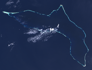
Bikini Atoll, known as Eschscholtz Atoll between the 1800s and 1946, is a coral reef in the Marshall Islands consisting of 23 islands surrounding a 229.4-square-mile (594.1 km2) central lagoon. The Atoll is at the northern end of the Ralik Chain, approximately 530 miles (850 km) northwest of the capital Majuro.

Enewetak Atoll is a large coral atoll of 40 islands in the Pacific Ocean and with its 296 people forms a legislative district of the Ralik Chain of the Marshall Islands. With a land area total less than 5.85 square kilometers (2.26 sq mi), it is no higher than 5 meters (16.4 ft) and surrounds a deep central lagoon, 80 kilometers (50 mi) in circumference. It is the second-westernmost atoll of the Ralik Chain and is 305 kilometers (190 mi) west from Bikini Atoll.

Ebeye is the most populous island of Kwajalein Atoll in the Marshall Islands, as well as the center for Marshallese culture in the Ralik Chain of the archipelago. Settled on 80 acres of land, it has a population of more than 15,000. Over 50% of the population is estimated to be under the age of 18.

The Compacts of Free Association (COFA) are international agreements establishing and governing the relationships of free association between the United States and the three Pacific Island sovereign states of the Federated States of Micronesia (FSM), the Republic of the Marshall Islands (RMI), and the Republic of Palau. As a result, these countries are sometimes known as the Freely Associated States (FAS's). All three agreements next expire in 2043.
Rongelap AtollRONG-gə-lap is an uninhabited coral atoll of 61 islands in the Pacific Ocean, and forms a legislative district of the Ralik Chain of the Marshall Islands. Its total land area is 8 square miles (21 km2). It encloses a lagoon with an area of 1,000 square miles (2,600 km2). It is historically notable for its close proximity to US hydrogen bomb tests in 1954, and was particularly devastated by fallout from the Castle Bravo test. The population asked the US to move them from Rongelap following the test due to high radiation levels with no success so they asked global environmental group Greenpeace to help. The Rainbow Warrior made four trips moving the islanders, their possessions and their homes to Majeto 180kms away.

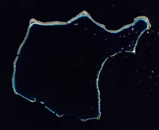
Kili Island or Kili Atoll is a small, 81 hectares island located in the Marshall Islands in the Pacific Ocean. As of 2021, 415 people lived on the island, many of whom were descended from islanders who originally lived on Bikini Atoll. They were relocated when they agreed to let the U.S. government temporarily use their home for nuclear testing in 1945. Kili Island became their home after two prior relocations failed. The island does not have a natural lagoon and cannot produce enough food to enable the islanders to be self-sufficient. It is part of the legislative district of the Ralik Chain of the Marshall Islands. The island is approximately 48 kilometers (30 mi) southwest of Jaluit. It is one of the smallest islands in the Marshall Islands.

The Pacific Proving Grounds was the name given by the United States government to a number of sites in the Marshall Islands and a few other sites in the Pacific Ocean at which it conducted nuclear testing between 1946 and 1962. The U.S. tested a nuclear weapon on Bikini Atoll on June 30, 1946. This was followed by Baker on July 24, 1946.

Bucholz Army Airfield is a United States Army airfield located on Kwajalein Atoll, Marshall Islands. Its position is ideal for refueling during trans-Pacific flights, and the airport is available to civilians through Air Marshall Islands and United Airlines.

Marshall Islands–United States relations are bilateral relations between Marshall Islands and the United States.

The following is an alphabetical list of topics related to the Marshall Islands.

Israel–Marshall Islands relations are diplomatic and other relations between Israel and the Marshall Islands.

Nuclear testing at Bikini Atoll consisted of the detonation of 24 nuclear weapons by the United States between 1946 and 1958 on Bikini Atoll in the Marshall Islands. Tests occurred at 7 test sites on the reef itself, on the sea, in the air, and underwater. The test weapons produced a combined yield of 42.2 Mt of TNT in explosive power.

Joseph Yuosang Yun is the former U.S. Special Presidential Envoy for Compact Negotiations, appointed in March 2022 by President Joe Biden to negotiate amendments to the Compact of Free Association (COFA), the agreement governing the relationship between the United States and the Freely Associated States (FAS) of the Federated States of Micronesia, the Republic of the Marshall Islands, and Palau.
The United States Special Presidential Envoy for Compact Negotiations is a dedicated diplomatic position created by the Biden White House in 2022 to negotiate amendments to the Compact of Free Association (COFA), the agreement governing the relationship between the United States and the Freely Associated States (FAS) of Micronesia, the Marshall Islands, and Palau. It is currently held by Ambassador Joseph Yun.

Naval Base Kwajalein was United States Navy base built on Kwajalein Atoll, in the Marshall Islands to support the World War II efforts in the Pacific War. The base was built after the Battle of Kwajalein ended 3 February 1944. The US Navy built airfields, a seaport and a craft repair depot on the captured islands. The base was part of the vast Naval Base Marshall Islands.

Naval Base Marshall Islands were United States Navy advance bases built on the Marshall Islands during World War II to support the Pacific War efforts. The bases were built by US Navy after the Marshall Islands campaign that captured the islands from the Empire of Japan. By February 1944 the United States Armed Forces had captured the islands. Most of the airfields and other facilities Japan had built were destroyed in allied bombing raids and naval bombardment. US Navy Seabee Construction Battalions arrived as soon as the area was secured and remove the debris. The Seabees quickly repaired, built and improved the airfield/runways and seaport. Seabees often worked around the clock to get airfields operational so that fighter aircraft and bombers could start operating. The bases were used for staging upcoming campaigns and for repair.
