
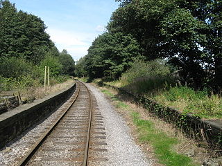
East Lancashire Railway is a 12.5-mile (20 km) heritage railway line in North West England which runs between Heywood, Greater Manchester and Rawtenstall in Lancashire. There are intermediate stations at Bury Bolton Street, Burrs Country Park, Summerseat and Ramsbottom, with the line crossing the border into Rossendale serving Irwell Vale and Rawtenstall. Before closure, the line terminated at Bacup.

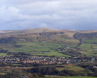
Rossendale is a district with borough status in Lancashire, England, located along the River Irwell and spanning a large valley. It is located south of Burnley and east of Blackburn. The borough borders Greater Manchester to the south and borders the boroughs of Bolton, Bury and Rochdale.
Ramsbottom is a market town in the Metropolitan Borough of Bury, Greater Manchester, England. The population at the 2011 census was 17,872.
Edenfield is a village within the Rossendale borough of Lancashire, England. Lying on the River Irwell, it is around 1.25 miles (2.0 km) north of Ramsbottom, 2.5 miles (4.0 km) south of Rawtenstall, and 6.0 miles (9.7 km) west of Norden, and has a total population of 2,080, reducing to 2,053 at the 2011 Census.

Stubbins is an industrial village in the southern part of the Rossendale Valley, Lancashire, England.
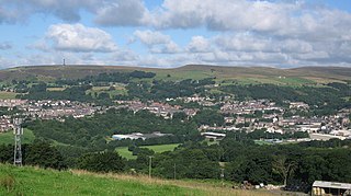
Rawtenstall is a town in the borough of Rossendale, Lancashire, England. The town lies 15 miles/24 km north of Manchester, 22 miles/35 km east of Preston and 45 miles/70 km south east of the county town of Lancaster. The town is at the centre of the Rossendale Valley. It had a population of 23,000.

Norden is a suburban village in the Metropolitan Borough of Rochdale, in Greater Manchester, England. Historically part of Lancashire, the village is situated on the western outskirts of Rochdale. There is a Rochdale Ward with the same name. At the 2011 Census, this ward had a population of 9,766.
Radcliffe Bridge railway station was a Railway Station in Radcliffe built on the Manchester, Bury and Rossendale Railway line, between Bury and Clifton, both in Greater Manchester. It was opened on 25 September 1846, and was closed 7 July 1958.
Stubbins railway station served the village of Stubbins, Rossendale, Lancashire, England. Opened by the East Lancashire Railway in 1847 on their line from Bury Bolton Street into Rossendale, it was situated next to the junction of the lines toward Accrington and to Rawtenstall and Bacup, but only had platforms on the latter route.

Haslingden railway station served the town of Haslingden, Rossendale, Lancashire. The station was built by the East Lancashire Railway (ELR) on their Bury to Accrington line and opened on 17 August 1848.

Baxenden railway station served the villages of Baxenden in Hyndburn and Rising Bridge in Rossendale. It was situated just inside the old boundary of Haslingden on the line from Bury Bolton Street to Accrington, which was opened in 1848 by the East Lancashire Railway. The station gave its name to the nearby Baxenden Bank, the two-mile section towards Accrington that included gradients as steep as 1 in 38.
Irwell Vale is a village within the Rossendale borough of Lancashire, in North West England. which lies at the confluence of the River Ogden and River Irwell.
The Manchester, Bury and Rossendale Railway, opened in 1846, ran between Clifton, Bury and Rossendale in Lancashire, England. The company merged with the Blackburn, Burnley, Accrington & Colne Extension Railway (BBA&CER) to form the East Lancashire Railway.
Withins Lane railway station was a railway station serving the town of Radcliffe in Lancashire.(now Greater Manchester), England.
Haslingden F.C. was a football club based in Rossendale, Lancashire. In 1994, they won the North West Counties Football League Division Two. Haslingden played at Ewood Bridge, later used by Stand Athletic and were members of the North West Counties League between 1993 and 1998. Although Division Two Champions in their first season Haslingden were not promoted until finishing runners up in 1997. They completed just one season in the top flight, finishing 16/22 before financial difficulties signalled the end of the line for the club based adjacent to the East Lancashire Railway. The Ewood Bridge ground forlorn and overgrown is still extant today.
Ewood Bridge may refer to:
104.7 Rossendale Radio is a community radio station in the north west of England, broadcasting on 104.7 FM to Haslingden, Rawtenstall, Ramsbottom and surrounding areas and online at www.rossendaleradio.com.

Lumb is a small village in the Rossendale district of Lancashire, England. It lies in the valley of the Whitewell Brook, 3 miles (5 km) north east of Rawtenstall. It should not be confused with the hamlet of Lumb near Edenfield, also in the Rossendale district.
