
Burnley is a town in Lancashire, England, with a 2001 population of 73,021. It is 21 miles (34 km) north of Manchester and 20 miles (32 km) east of Preston, at the confluence of the River Calder and River Brun.

The Calder Valley line is a railway route in Northern England between the cities of Leeds and Manchester as well as the seaside resort of Blackpool. It is the slower of the two main rail routes between Leeds and Manchester, and the northernmost of the three main trans-Pennine routes.

Burnley Manchester Road is the main railway station in Burnley, Lancashire, England. It is situated on the Calder Valley Line 24 1⁄2 miles (39.4 km) east of Preston, near to the route's junction with the East Lancashire Line.

Castleton railway station serves Castleton in the Metropolitan Borough of Rochdale, Greater Manchester, England. It is 8¾ miles (14 km) north of Manchester Victoria on the Caldervale Line operated and managed by Northern.

Pleasington railway station serves the village of Pleasington in Lancashire, England. The station is on the East Lancashire Line 3 miles (5 km) west of Blackburn railway station. It is managed by Northern, who also provide all the passenger services calling there.
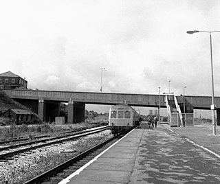
Rose Grove railway station is located in the western part of Burnley in Lancashire, England, 11 miles (17 km) east of Blackburn railway station. The railway reached here in 1848 when the East Lancashire Railway Company opened a station

The River Calder is a major tributary of the River Ribble in Lancashire, England and is around 20 miles (32 km) in length.
Oldham Road railway station was one of three railway stations that used to serve the town of Ashton-under-Lyne. The station closed in May 1959 following the withdrawal of passenger services on the line, although the route remained in use for freight traffic until 1967. Ashton Charlestown is the only remaining station in Ashton.

Miles Platting railway station served the district of Miles Platting in Manchester from 1844 until closure on 27 May 1995. The station was opened on 1 January 1844 by the Manchester and Leeds Railway; after amalgamating with other railways, this became the Lancashire and Yorkshire Railway in 1847. The station was situated at the junction of the lines to Stalybridge and Rochdale, and had platforms on both routes. Little trace remains of the station today, as the platforms were removed and the buildings demolished after closure. However, a length of platform awning has been re-erected at Ramsbottom station on the preserved East Lancs Railway.

Newton Heath Railway Station served the district of Newton Heath in east Manchester. It was opened by the Lancashire and Yorkshire Railway (LYR) on 1 December 1853 and was closed by British Railways on 3 January 1966.
Cornholme railway station served the village of Cornholme in West Yorkshire, England on the Copy Pit line. The station was opened by the Lancashire and Yorkshire Railway in July 1878 and closed by the LMS on 26 September 1938. The line remains in use for passenger trains between York/Leeds and Blackpool, which run non-stop between Hebden Bridge and Burnley, and also for trains between Manchester and Blackburn, via Todmorden, utilising the reinstated Todmorden Curve.
Portsmouth railway station was on the Copy Pit line and served the village of Portsmouth, which was part of Lancashire, before being incorporated into the West Riding of Yorkshire in the late 1880s. It is now in the successor county of West Yorkshire. It opened along with the line in 1849 but was closed as an economy measure on 7 July 1958. Few traces of the station remain, although the line itself remains in use for passenger trains between Burnley and Hebden Bridge or Todmorden.
Holme railway station served Holme Chapel on the Copy Pit line. The station closed in July 1930 and the line now serves as a non-stop route between Hebden Bridge and Burnley.

The Leeds and Bradford Extension Railway was an early British railway company in the West Riding of Yorkshire. It built a line from Shipley near Bradford through Keighley and Skipton to Colne. The Skipton–Colne Line closed in 1970, but the remainder of the line is still in use today, and once formed part of the Midland Railway's main line route from London to Glasgow.
Friezland Railway Station served the Hamlet of Friezland in Saddleworth until closure on 1 January 1917. It was built by the London and North Western Railway on its Micklehurst Line.
Micklehurst Railway Station served the town of Mossley in Cheshire. It was built by the London and North Western Railway on its Micklehurst Line. The station closed for passengers in 1907 and to freight on 19 February 1962 but the line through the station remained open for passenger traffic until 7 September 1964. The station building on the up side are still standing and are used as a private residence.

The Burnley Way is a 40-mile (64 km) long distance footpath in Lancashire, England. As a circular walk it can be walked from any point, but it is common to start and finish at the Weavers' Triangle Visitor Centre in Burnley. It covers a range of terrain from canal towpaths to open moorland.
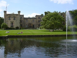
The Towneley or Townley family are an English (UK) family whose ancestry can be traced back to Norman England. Towneley Hall in Burnley, Lancashire, was the family seat until its sale, together with the surrounding park, to the corporation of Burnley in 1901. Towneley Hall is now a Grade I listed building and a large museum and art gallery within Towneley Park (UK).

The Burnley Coalfield is the most northerly portion of the Lancashire Coalfield. Surrounding Burnley, Nelson, Blackburn and Accrington, it is separated from the larger southern part by an area of Millstone Grit that forms the Rossendale anticline. Occupying a syncline, it stretches from Blackburn past Colne to the Yorkshire border where its eastern flank is the Pennine anticline.

Towneley Colliery or Towneley Desmesne was a coal mine on the Burnley Coalfield in Burnley, Lancashire, England. Sunk in the late 1860s, it was linked to the Lancashire and Yorkshire Railway's Burnley to Todmorden line which became known as the Copy Pit route and, by tramway, to the Leeds and Liverpool Canal.

