
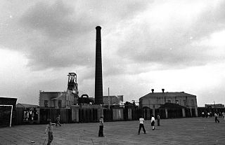
Bank Hall Colliery was a coal mine on the Burnley Coalfield in Burnley, Lancashire near the Leeds and Liverpool Canal. Sunk in the late 1860s, it was the town's largest and deepest pit and had a life of more than 100 years.
Bank Hall Colliery was a coal mine on the Burnley Coalfield in Burnley, Lancashire near the Leeds and Liverpool Canal. Sunk in the late 1860s, it was the town's largest and deepest pit and had a life of more than 100 years.
The Rev. John Hargreaves (1732-1812), had purchased the Bank Hall estate—previously called Bank Top—by 1796. He entered the local coal industry through marriage in 1755 and in 1797 he acquired the lease-holds for most of the mineral rights in the area. After his death, the company adopted the name 'The Executors of John Hargreaves'. His nephew, Colonel John Hargreaves (1775-1834) continued the business until his death. His son had died young, and the property, including Bank Hall and Ormerod Hall in Cliviger, was divided between two daughters. The younger, Charlotte Anne, had married General Sir James Yorke Scarlett, a hero of the Battle of Balaclava, but the couple produced no offspring. The elder, Eleanor Mary, married the Rev. William Thursby and thus the company came under the control of the Thursby family. [1] [2] The Bank Hall estate covered a greater area than the later coal mine, with the hall itself located on the southwest side of the canal next to Colne Road. [3] Its grounds on the River Brun, today make up part of Thompson Park. [4] The estate also presumably covered the site of Queen's Park—southeast of the mine—which was donated to the Burnley Corporation by Sir John Hardy Thursby in 1888, for the purpose of creating the first public park in the town. [5]
Bank Hall Colliery's first shafts were sunk to the Arley mine [lower-alpha 1] at a depth of 287 yards by Executors of John Hargreaves between 1865 and 1869. The four feet thick seam was worked until 1925. The King mine was worked between 1905 and 1925, and the Dandy (or Upper Arley) mine from 1910 to 1935. [6] No. 3 shaft was sunk to the Dandy mine in 1903 and became known as the Dandy Pit. [7] No.4 shaft was sunk to the Union mine, which had been formed by the merger of the Upper Foot and true Lower Mountain mines. Production from the Union mine started in 1915 and became the pit's the major source of coal. [6] The fourth shaft at 1,500 feet was the deepest in the coalfield. [7]
Worsley Mesnes Ironworks in Wigan built a twin horizontal winding engine with 26 inch cylinders for No. 1 shaft in 1912. Its 18 foot drum could wind up to 1,554 feet. Yates & Thom of Blackburn built No. 4 shaft's cross compound horizontal engine in 1914. It had 38 inch and 60 inch cylinders, a 19 feet drum and could wind to 1,464 feet. Walker Brothers of Wigan supplied a steam fan engine with a 5 feet diameter fly wheel. [8]
The colliery was taken over by the National Coal Board (NCB) on 1 January 1947 and significant investments were made. Haulage roads were made for battery locomotives, which pulled five-ton mine cars and the pit botton at No.4 Shaft was modernised. [6]
The Union mine proved to be gassy and ignitions of firedamp were caused by sparks made when mechanised cutter picks hit coal balls containing nodules of iron pyrites. The problems led to the NCB stopping the last coal face working in January 1971 and closed the pit on 17 April. Salvage work was completed and the site cleared in 1972. [6] [9]
Agecroft Colliery was a coal mine on the Manchester Coalfield that opened in 1844 in the Agecroft district of Pendlebury, Lancashire, England. It exploited the coal seams of the Middle Coal Measures of the Lancashire Coalfield. The colliery had two spells of use; the first between 1844 and 1932, when the most accessible coal seams were exploited, and a second lease of life after extensive development in the late 1950s to access the deepest seams.
The Thursby Baronetcy, of Ormerod House in the Parish of Burnley in the County Palatine of Lancaster and of Holmhurst in the Parish of Christchurch in the County of Southampton, was a title in the Baronetage of the United Kingdom. It was created on 26 July 1887 for John Hardy Thursby, then Honorary Colonel of the 3rd Battalion, East Lancashire Regiment.

The Lancashire Coalfield in North West England was an important British coalfield. Its coal seams were formed from the vegetation of tropical swampy forests in the Carboniferous period over 300 million years ago.
The Astley and Tyldesley Collieries Company formed in 1900 owned coal mines on the Lancashire Coalfield south of the railway in Astley and Tyldesley, then in the historic county of Lancashire, England. The company became part of Manchester Collieries in 1929 and some of its collieries were nationalised in 1947.
Tyldesley Coal Company was a coal mining company formed in 1870 in Tyldesley, on the Manchester Coalfield in the historic county of Lancashire, England that had its origins in Yew Tree Colliery, the location for a mining disaster that killed 25 men and boys in 1858.
Fletcher, Burrows and Company was a coal mining company that owned collieries and cotton mills in Atherton, Greater Manchester, England. Gibfield, Howe Bridge and Chanters collieries exploited the coal mines (seams) of the middle coal measures in the Manchester Coalfield. The Fletchers built company housing at Hindsford and a model village at Howe Bridge which included pithead baths and a social club for its workers. The company became part of Manchester Collieries in 1929. The collieries were nationalised in 1947 becoming part of the National Coal Board.

Astley Green Colliery was a coal mine in Astley, Greater Manchester, then in the historic county of Lancashire, England. It was the last colliery to be sunk in Astley. Sinking commenced in 1908 by the Pilkington Colliery Company, a subsidiary of the Clifton and Kersley Coal Company, at the southern edge of the Manchester Coalfield, working the Middle Coal Measures where they dipped under the Permian age rocks under Chat Moss. The colliery was north of the Bridgewater Canal. In 1929 it became part of Manchester Collieries, and in 1947 was nationalised and integrated into the National Coal Board. It closed in 1970, and is now Astley Green Colliery Museum.
Parsonage Colliery was a coal mine operating on the Lancashire Coalfield in Leigh, then in the historic county of Lancashire, England. The colliery, close to the centre of Leigh and the Bolton and Leigh Railway was sunk between 1913 and 1920 by the Wigan Coal and Iron Company and the first coal was wound to the surface in 1921. For many years its shafts to the Arley mine were the deepest in the country. The pit was close to the town centre and large pillars of coal were left under the parish church and the town's large cotton mills.
Pendleton Colliery was a coal mine operating on the Manchester Coalfield after the late 1820s on Whit Lane in Pendleton, Salford, then in the historic county of Lancashire, England.

Gibfield Colliery was a coal mine owned by Fletcher, Burrows and Company in Atherton, then in the historic county of Lancashire, England.

Howe Bridge Colliery was a coal mine which was part of the Fletcher, Burrows and Company's collieries at Howe Bridge in Atherton, Greater Manchester, then in the historic county of Lancashire, England.
Chanters Colliery was a coal mine which was part of the Fletcher, Burrows and Company's collieries at Hindsford in Atherton, Greater Manchester, then in the historic county of Lancashire, England.
Yew Tree Colliery was a coal mine operating on the Manchester Coalfield after 1845 in Tyldesley, Greater Manchester, then in the historic county of Lancashire, England.
Cleworth Hall Colliery was a coal mine operating on the Manchester Coalfield after 1874 in Tyldesley, Greater Manchester, then in the historic county of Lancashire, England.
Peelwood Colliery was a coal mine operating on the Manchester Coalfield after 1883 in Shakerley, Tyldesley, Greater Manchester, then in the historic county of Lancashire, England.
Nelson Pit was a coal mine operating on the Manchester Coalfield from the 1830s or 1840s in Shakerley, Tyldesley, Greater Manchester, then in the historic county of Lancashire, England.
The Oldham Coalfield is the most easterly part of the South Lancashire Coalfield. Its coal seams were laid down in the Carboniferous period and some easily accessible seams were worked on a small scale from the Middle Ages and extensively from the beginning of the Industrial Revolution in the early 19th century until the middle of the 20th century.

The Burnley Coalfield is the most northerly portion of the Lancashire Coalfield. Surrounding Burnley, Nelson, Blackburn and Accrington, it is separated from the larger southern part by an area of Millstone Grit that forms the Rossendale anticline. Occupying a syncline, it stretches from Blackburn past Colne to the Yorkshire border where its eastern flank is the Pennine anticline.
Hapton Valley Colliery was a coal mine on the edge of Hapton near Burnley in Lancashire, England. Its first shafts were sunk in the early 1850s and it had a life of almost 130 years, surviving to be the last deep mine operating on the Burnley Coalfield.
Towneley Colliery or Towneley Desmesne was a coal mine on the Burnley Coalfield in Burnley, Lancashire, England. Sunk in the late 1860s, it was linked to the Lancashire and Yorkshire Railway's Burnley to Todmorden line which became known as the Copy Pit route and, by tramway, to the Leeds and Liverpool Canal.
Coordinates: 53°47′53″N2°14′06″W / 53.798°N 2.235°W
Culture and infrastructure of the Borough of Burnley | ||||||||||
|---|---|---|---|---|---|---|---|---|---|---|
| Transport |
|  | ||||||||
| Education | ||||||||||
| Sport | ||||||||||
| History |
| |||||||||
| Media | ||||||||||
| Politics | ||||||||||