Burnley Coalfield

Last updated

Map all coordinates using: OpenStreetMap
The terminus of the ginny track (tramway) at Rowley Colliery c.1868 Rowley ginny track terminus.png
The terminus of the ginny track (tramway) at Rowley Colliery c.1868

The Burnley Coalfield is the most northerly portion of the Lancashire Coalfield. Surrounding Burnley, Nelson, Blackburn and Accrington, it is separated from the larger southern part by an area of Millstone Grit that forms the Rossendale anticline. Occupying a syncline, it stretches from Blackburn past Colne to the Yorkshire border where its eastern flank is the Pennine anticline.

Contents

Geography and geology

The Burnley Coalfield which surrounds Burnley, Nelson, Blackburn and Accrington is the most northerly portion of the Lancashire Coalfield. The Rossendale anticline, an area of Millstone Grit, separates it from the larger southern part of the coalfield. [1] Occupying a syncline bounded by the Pendle monocline to the north, the coalfield stretches from Blackburn, eastwards past Colne to the Pennine anticline on the border with Yorkshire. [2]

The coalfield's seams are the Westphalian Coal Measures of the Carboniferous period, laid down from the vegetation of tropical swampy forests more than 300 million years ago but here, only the Lower Coal Measures remain. Within the coalfield, the dip in the strata varies from shallow to the south and west but steeper where there are faults. [3] Named faults include the Deerplay Fault in the middle of the district which is associated with a line to west where the Lower Mountain and Upper Foot mines combine to form the Union mine. The Cliviger Valley Fault has a throw of up to 400 metres (1,300 ft) in the Cliviger valley. The intersecting Theiveley Lead Mine and nearby Hameldon Faults are some of a smaller number of easterly aligned structures which separate the coalfield from the horizontal strata of Rossendale. [3] [4] Other unnamed faults include one between Altham and Huncoat which is considered to be the boundary between the Burnley and Accrington district. [2]

Around the district, 19 coal seams, of varying thickness were exploited over time. [5] The most important were the Lower/Union and Upper Mountain, Dandy, King and Arley mines. [lower-alpha 1] Seams were generally less than 1.5 metres in thickness, frequently less. [6] One notable exception occurs in the Calder Valley near Gawthorpe Hall, where as a result of the absence of the Tim Bobbin Rock which usually separates the King and Fulledge Thin mines, the Padiham Thick mine is up to 5.3 metres thick. [7] [8] Coal extracted from the Arley, Upper and Lower Mountain mines was used to produce high grade metallurgical coke which was in high demand for industry, whereas coal from the Union/Upper Foot mines had a high sulphur content making it unsuitable for making coke. [5]

The Union mine is contaminated with in-seam concretions known locally as coal balls or bobbers, spherical concretions, composed of limestone measuring from 0.1 to 1.0 metre in diameter that posed hazards for mining. They were largely responsible for the closure of Bank Hall Colliery, the area's largest and deepest pit.

History

A collapsed bell pit at Castercliff near Nelson Castercliff Camp Hillfort - geograph.org.uk - 718864.jpg
A collapsed bell pit at Castercliff near Nelson

Coal was exploited in the 13th century at Trawden near Colne where receipts are mentioned in a rent roll from 1295. Coal was also bought at Cliviger. [9] The first coals were extracted at the outcrops before shaft and adit mining were adopted. The coal industry grew in the 16th and 17th centuries, developing from manorial tenants who dug coal for their own use into fixed term leases in return for rent. Coal was mined all around Burnley, mostly from shafts. By 1800, more than a dozen pits had been sunk in central Burnley. [10]

The arrival of the Leeds and Liverpool Canal was a catalyst for industrialisation as was the coming of the Lancashire and Yorkshire Railway line through Burnley to Colne in 1848. [11] In the 1840s some old small pits such as Cleggs Pit and Habergham closed and larger collieries were sunk at Bank House Colliery, Whittlefield Colliery and the old Fulledge Colliery was redeveloped and linked by a tramway to canal. Tramways came into more common use in the 1880s and several collieries in the town were linked by the system. [12]

Several collieries were nationalised under the Coal Industry Nationalisation Act 1946 on vesting day, 1 January 1947. [13] After the 1950s much of the area was opencasted. [14] Coal was opencast at Helm, Royal Zone, Gawthorpe Hall and Tipping Hill. [14] [15] [16] Hill Top Colliery, a very small drift mine near Bacup, was still producing small amounts of coal in 2010 before complete closure in 2014. [17]

Collieries

Accrington district

Monument to the Moorfield disaster. Moorfield Monument 1.jpg
Monument to the Moorfield disaster.

Burnley district

Monument in Bank Hall Park Bank Hall Park - geograph.org.uk - 675291.jpg
Monument in Bank Hall Park
An old surface drift at the site of Porters Gate Colliery. Porters Gate Colliery, Hapton 4.jpg
An old surface drift at the site of Porters Gate Colliery.
Deerplay filter beds Deerplay Mine - geograph.org.uk - 1122200.jpg
Deerplay filter beds
The remains of the engine house at Fox Clough Colliery Fox Clough engine house 4.jpg
The remains of the engine house at Fox Clough Colliery
Old Meadows Pumping Station Old Meadows Pumping Station - geograph.org.uk - 673872.jpg
Old Meadows Pumping Station
The man-made lake at Rowley Rowley Lake, Burnley.jpg
The man-made lake at Rowley

See also

Related Research Articles

<span class="mw-page-title-main">Borough of Burnley</span> Borough in Lancashire, England

The Borough of Burnley is a local government district with the borough status in Lancashire, England. It has an area of 42.7 square miles (110.7 km2) and a population of 94,646 (2021), and is named after its largest town, Burnley. Other notable settlements include Padiham, Hapton, Worsthorne, Briercliffe and Cliviger.

<span class="mw-page-title-main">Oswaldtwistle</span> Human settlement in England

Oswaldtwistle is a town in the Hyndburn borough of Lancashire, England, 3 miles (5 km) southeast of Blackburn, contiguous with Accrington and Church. The town has a rich industrial heritage, being home to James Hargreaves, inventor of the spinning jenny and Sir Robert Peel of calico printing fame. The Leeds and Liverpool Canal passes through the town and was responsible for the export of much of the area's cotton produce.

<span class="mw-page-title-main">Dunnockshaw</span> Human settlement in England

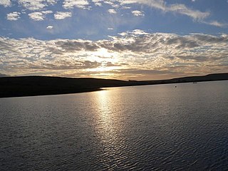
Dunnockshaw or Dunnockshaw and Clowbridge is a civil parish in the borough of Burnley, in Lancashire, England. The parish is situated between Burnley and Rawtenstall. According to the United Kingdom Census 2011, the parish has a population of 185.

<span class="mw-page-title-main">River Calder, Lancashire</span> Tributary of the River Ribble in England

The River Calder is a major tributary of the River Ribble in Lancashire, England and is around 20 miles (32 km) in length.

<span class="mw-page-title-main">Cliviger</span> Human settlement in England

Cliviger is a civil parish in the Borough of Burnley, in Lancashire, England. It is situated to the southeast of Burnley, and northwest of Todmorden. According to the 2011 census, the parish has a population of 2,238.

<span class="mw-page-title-main">Huncoat</span> Human settlement in England

Huncoat is a village in Lancashire, England; situated in the North West. It is located to the east of Accrington. It is a ward of Hyndburn where the population taken at the 2011 census was 4,418.

<span class="mw-page-title-main">Hapton, Lancashire</span> Human settlement in England

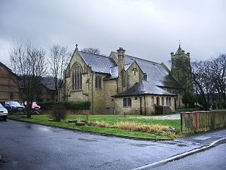
Hapton is a village and civil parish in the Borough of Burnley in Lancashire, England, 3 miles (4.8 km) west of Burnley, with a railway station on the East Lancashire Line. At the United Kingdom Census 2011, it had a population of 1,979.

<span class="mw-page-title-main">Lancashire Coalfield</span> Coal mining region in England

The Lancashire Coalfield in North West England was an important British coalfield. Its coal seams were formed from the vegetation of tropical swampy forests in the Carboniferous period over 300 million years ago.

Gin Pit was a coal mine operating on the Lancashire Coalfield from the 1840s in Tyldesley, Greater Manchester then in the historic county of Lancashire, England. It exploited the Middle Coal Measures of the Manchester Coalfield and was situated to the south of the Tyldesley Loopline.

Yew Tree Colliery was a coal mine operating on the Manchester Coalfield after 1845 in Tyldesley, Greater Manchester, then in the historic county of Lancashire, England.

Peelwood Colliery was a coal mine operating on the Manchester Coalfield after 1883 in Shakerley, Tyldesley, Greater Manchester, then in the historic county of Lancashire, England.

Nelson Pit was a coal mine operating on the Manchester Coalfield from the 1830s or 1840s in Shakerley, Tyldesley, Greater Manchester, then in the historic county of Lancashire, England.

<span class="mw-page-title-main">Hameldon Hill</span>

Hameldon Hill is a Carboniferous sandstone hill with a summit elevation of 409 metres (1,342 ft), situated between the towns of Burnley and Accrington in Lancashire, England. It is listed as a "HuMP" or "Hundred Metre Prominence", its parent being Freeholds Top, a Marilyn near Bacup.

<span class="mw-page-title-main">Whitewell Brook</span> River in Lancashire, England

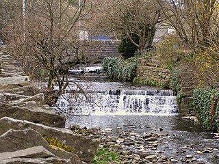
Whitewell Brook is a minor river in Lancashire, England. It is 4.34 miles (6.99 km) long and has a catchment area of 7.67 square miles (19.86 km2).

<span class="mw-page-title-main">Bank Hall Colliery</span> Decommissioned coal mine in Lancashire

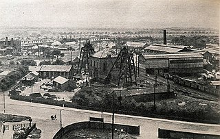
Bank Hall Colliery was a coal mine on the Burnley Coalfield in Burnley, Lancashire near the Leeds and Liverpool Canal. Sunk in the late 1860s, it was the town's largest and deepest pit and had a life of more than 100 years.

Hapton Valley Colliery was a coal mine on the edge of Hapton near Burnley in Lancashire, England. Its first shafts were sunk in the early 1850s and it had a life of almost 130 years, surviving to be the last deep mine operating on the Burnley Coalfield.

<span class="mw-page-title-main">Towneley Colliery</span>

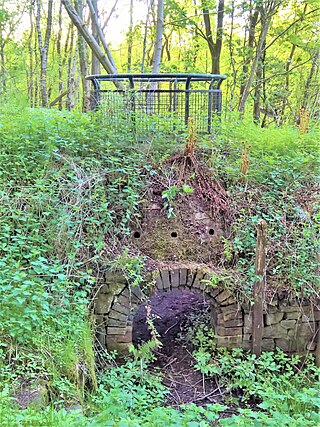
Towneley Colliery or Towneley Desmesne was a coal mine on the Burnley Coalfield in Burnley, Lancashire, England. Sunk in the late 1860s, it was linked to the Lancashire and Yorkshire Railway's Burnley to Todmorden line which became known as the Copy Pit route and, by tramway, to the Leeds and Liverpool Canal.

<span class="mw-page-title-main">Ellesmere Colliery</span> Former coal mine in Walkden, Manchester, England

Ellesmere Colliery was a coal mine in Walkden, Manchester, England. The pit was located on Manchester Road, a short distance south of Walkden town centre.

References

Notes

  1. In this part of Lancashire a coal seam is referred to as a mine and the coal mine as a colliery or pit.

Citations

  1. Davies 2010, p. 37.
  2. 1 2 Williamson 1999, p. 5.
  3. 1 2 Hough 2004, p. 20.
  4. Williamson 1999, pp. 4–8
  5. 1 2 3 Williamson 1999, p. 8.
  6. Williamson 1999, p. 9.
  7. Hough 2004, p. 15.
  8. Williamson 1999, p. 12.
  9. Davies 2010, p. 12.
  10. 1 2 Mitchell & Hartley 2005, p. 21.
  11. Mitchell & Hartley 2005, p. 29.
  12. Mitchell & Hartley 2005, p. 23.
  13. The Burnley Coalfield Collieries after Nationalisation in 1947, Northern Mine Research Society, retrieved 30 March 2018
  14. 1 2 Hough 2004, p. 21.
  15. Historic England. "Monument No. 1381336 (1381336)". Research records (formerly PastScape). Retrieved 2 April 2018.
  16. Historic England. "Monument No. 1381455 (1381455)". Research records (formerly PastScape). Retrieved 2 April 2018.
  17. Davies 2010, p. 35.
  18. Historic England, "Remains of Aspen Colliery, associated beehive coking ovens and canal basin (1016943)", National Heritage List for England , retrieved 29 April 2018
  19. Lancashire and Furness (Map). 1 : 2,500. County Series. Ordnance Survey. 1893.
  20. Lancashire and Furness (Map). 1 : 2,500. County Series. Ordnance Survey. 1893.
  21. Lancashire and Furness (Map). 1 : 10,560. County Series. Ordnance Survey. 1848.
  22. Lancashire and Furness (Map). 1 : 10,560. County Series. Ordnance Survey. 1848.
  23. Huncoat Colliery, Northern Mine Research Society, retrieved 6 April 2018
  24. Moorfield Colliery, Northern Mine Research Society, retrieved 31 March 2018
  25. Nadin 1997, pp. 113–119.
  26. Davies 2010, p. 220.
  27. Lancashire and Furness (Map). 1 : 2,500. County Series. Ordnance Survey. 1893.
  28. Lancashire and Furness (Map). 1 : 2,500. County Series. Ordnance Survey. 1893.
  29. Bond, B (1984), "The Burnley Coalfield" (PDF), British Mining No. 25 Memoirs 1984, Northern Mine Research Society, pp. 31–37
  30. Rishton Colliery, Northern Mine Research Society, retrieved 7 April 2018
  31. Lancashire and Furness (Map). 1 : 2,500. County Series. Ordnance Survey. 1931.
  32. Scaitcliffe Colliery, Northern Mine Research Society, retrieved 31 March 2018
  33. Lancashire and Furness (Map). 1 : 2,500. County Series. Ordnance Survey. 1931.
  34. Lancashire and Furness (Map). 1 : 10,560. County Series. Ordnance Survey. 1848.
  35. Lancashire and Furness (Map). 1 : 2,500. County Series. Ordnance Survey. 1893.
  36. Bank Hall Colliery, Northern Mine Research Society, retrieved 28 March 2018
  37. Ashmore 1969, p. 251.
  38. Nadin 1997, p. 31.
  39. Lancashire and Furness (Map). 1 : 2,500. County Series. Ordnance Survey. 1912.
  40. Williamson 1999, p. 15.
  41. Lancashire and Furness (Map). 1 : 2,500. County Series. Ordnance Survey. 1931.
  42. Black Clough Colliery, Northern Mines Research Society, retrieved 30 March 2018
  43. Lancashire and Furness (Map). 1 : 2,500. County Series. Ordnance Survey. 1930.
  44. Nadin 1997, p. 46.
  45. Nadin 1997, p. 121-122.
  46. The Burnley Coalfield Calder Colliery, Northern Mine Research Society, retrieved 30 March 2018
  47. Williamson 1999, pp. 10, 16.
  48. Lancashire and Furness (Map). 1 : 2,500. County Series. Ordnance Survey. 1931.
  49. Davies 2010, p. 149.
  50. Clifton Colliery, Northern Mine Research Society, retrieved 3 April 2018
  51. Lancashire and Furness (Map). 1 : 2,500. County Series. Ordnance Survey. 1891.
  52. 1 2 The Copy Pit, Cliviger nr. Burnley, Lancashire County Council , retrieved 1 April 2018
  53. 1 2 3 4 5 6 Copy Pit Summit and the collieries formerly served by the Copy Pit route, Disused Stations, retrieved 2 April 2018
  54. Lancashire and Furness (Map). 1 : 2,500. County Series. Ordnance Survey. 1891.
  55. Davies 2010, p. 151.
  56. Deerplay Colliery, Northern Mine Research Society, retrieved 5 April 2018
  57. 1 2 Nadin 1997, pp. 74–75.
  58. Ashmore 1969, p. 260.
  59. Lancashire and Furness (Map). 1 : 10,560. County Series. Ordnance Survey. 1848.
  60. Lancashire and Furness (Map). 1 : 2,500. County Series. Ordnance Survey. 1893.
  61. Topping, Graham, ed. (November 2017), Northern Mine Research Society Newsletter (PDF), Northern Mine Research Society, p. 17, retrieved 23 April 2018
  62. Lancashire and Furness (Map). 1 : 10,560. County Series. Ordnance Survey. 1848.
  63. Nadin 1997, pp. 9, 76.
  64. Bennett 1949, pp. 90–91.
  65. Lancashire and Furness (Map). 1 : 2,500. County Series. Ordnance Survey. 1891.
  66. Lancashire and Furness (Map). 1 : 2,500. County Series. Ordnance Survey. 1891.
  67. Nadin 1997, pp. 81–83.
  68. Bennett 1949, p. 109.
  69. Lancashire and Furness (Map). 1 : 2,500. County Series. Ordnance Survey. 1891.
  70. Nadin 1997, pp. 85–87.
  71. Lancashire and Furness (Map). 1 : 2,500. County Series. Ordnance Survey. 1891.
  72. Lancashire and Furness (Map). 1 : 2,500. County Series. Ordnance Survey. 1912.
  73. 1 2 Hapton Valley Colliery, Northern Mine Research Society, retrieved 29 March 2018
  74. 1 2 Thorny Bank Colliery, Northern Mine Research Society, retrieved 5 May 2018
  75. Lancashire and Furness (Map). 1 : 2,500. County Series. Ordnance Survey. 1961.
  76. Davies 2010, p. 221.
  77. Coal in North Western Area, Durham Mining Museum, retrieved 1 May 2018
  78. Lancashire and Furness (Map). 1 : 2,500. County Series. Ordnance Survey. 1848.
  79. Lancashire and Furness (Map). 1 : 10,560. County Series. Ordnance Survey. 1848.
  80. Nadin 1997, pp. 110–112.
  81. Ashmore 1969, p. 250.
  82. Old Meadows Colliery, Northern Mine Research Society, retrieved 10 April 2018
  83. 1 2 Davies 2010, p. 150.
  84. Lancashire and Furness (Map). 1 : 2,500. County Series. Ordnance Survey. 1891.
  85. Reedley Colliery, Northern Mine Research Society, retrieved 8 April 2018
  86. Lancashire and Furness (Map). 1 : 2,500. County Series. Ordnance Survey. 1891.
  87. Wood End Colliery, Northern Mine Research Society, retrieved 8 April 2018
  88. Fence Drift Mines, Northern Mine Research Society, retrieved 8 April 2018
  89. Roger Frost (16 June 2015). "Celebrating the history of Burnley's parks". Clitheroe Advertiser. Retrieved 9 December 2017.
  90. Lancashire and Furness (Map). 1 : 2,500. County Series. Ordnance Survey. 1893.
  91. 1 2 "Colliery Explosion Inquest", Burnley Advertiser, British Newspaper Archive via Findmypast, 22 November 1856, retrieved 9 April 2018(subscription required)
  92. Nadin 1997, p. 56.
  93. Winstanley (ed.). "UK Mining Disasters 1850 - 54" (PDF). p. 1. Archived from the original (PDF) on 3 March 2016. Retrieved 27 July 2017.
  94. Ashmore 1969, p. 292.
  95. Lancashire and Furness (Map). 1 : 10,560. County Series. Ordnance Survey. 1848.
  96. Nadin 1997, pp. 139–143.
  97. Towneley Colliery, Northern Mine Research Society, retrieved 1 April 2018
  98. Lancashire and Furness (Map). 1 : 10,560. County Series. Ordnance Survey. 1848.

Bibliography