
Lancashire is a ceremonial, non-metropolitan, and historic county in North West England; the borders of these three areas differ significantly.

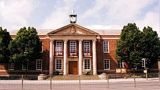
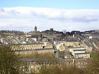
Burnley is a town and the administrative centre of the wider Borough of Burnley in Lancashire, England, with a 2001 population of 73,021. It is 21 miles (34 km) north of Manchester and 20 miles (32 km) east of Preston, at the confluence of the River Calder and River Brun.
Padiham is a town and civil parish on the River Calder, about three miles (5 km) west of Burnley, Lancashire, England. It forms part of the Borough of Burnley. Originally by the River Calder, it is edged by the foothills of Pendle Hill to the north-west and north-east. The United Kingdom Census 2011 gave a parish population of 10,098, estimated in 2019 at 10,138.

The Borough of Burnley is a local government district with the borough status in Lancashire, England. It has an area of 42.7 square miles (110.7 km2) and a population of 94,646 (2021), and is named after its largest town, Burnley. Other notable settlements include Padiham, Hapton, Worsthorne, Briercliffe and Cliviger.
Colne is a market town and civil parish in the Borough of Pendle in Lancashire, England. Located 3 mi (4.8 km) northeast of Nelson, 6 mi (9.7 km) north-east of Burnley, 25 mi (40 km) east of Preston and 30 mi (48 km) west of Leeds.

The Calder Valley line is a railway route in Northern England between the cities of Leeds and Manchester as well as the seaside resort of Blackpool. It is the slower of the two main rail routes between Leeds and Manchester, and the northernmost of the three main trans-Pennine routes.

Bamber Bridge railway station serves the village of Bamber Bridge in Lancashire, England. It is situated on the East Lancashire Line and is managed by Northern.
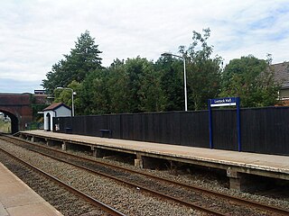
Lostock Hall railway station is a railway station serving the village of Lostock Hall in the South Ribble borough of Lancashire, England. It is on the East Lancashire Line and is managed by Northern, who also provide all passenger trains serving it.

Todmorden railway station serves the town of Todmorden in West Yorkshire, England, originally on the Yorkshire/Lancashire border. It was built by the Manchester and Leeds Railway and is on the Calder Valley Line 23 miles (37 km) west of Leeds and 17 miles (27 km) north-east of Manchester Victoria.
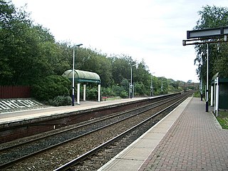
Huncoat railway station is a railway station which serves the village of Huncoat, between Accrington and Burnley in Lancashire, England. The station is 8 miles (13 km) east of Blackburn railway station on the East Lancashire Line operated by Northern.

The River Calder is a major tributary of the River Ribble in Lancashire, England and is around 20 miles (32 km) in length.

Cliviger is a civil parish in the Borough of Burnley, in Lancashire, England. It is situated to the southeast of Burnley, and northwest of Todmorden. According to the 2011 census, the parish has a population of 2,238.
Towneley railway station was a station in Lancashire which served Burnley Wood and the nearby Towneley Hall on the eastern edge of Burnley. Opened on 12 November 1849 by the Lancashire and Yorkshire Railway, it was served by local trains on the Todmorden to Burnley line until closure by British Railways London Midland Region on 4 August 1952. The station house survives as a private residence, whilst the signal box remains in use to supervise a busy level crossing next to the former station site.

Hapton is a village and civil parish in the Borough of Burnley in Lancashire, England, 3 miles (4.8 km) west of Burnley, with a railway station on the East Lancashire Line. At the United Kingdom Census 2011, it had a population of 1,979.

Briercliffe is a civil parish in the borough of Burnley, in Lancashire, England. It is situated 3 miles (4.8 km) north of Burnley. The parish contains suburbs of Burnley, and the rural area north east of the town. Hamlets in the parish include Cockden, Lane Bottom and in the Extwistle area, the tiny hamlet of Roggerham. According to the United Kingdom Census 2011, the parish has a population of 4,031.

Padiham railway station in Station Road, Padiham, Lancashire, England was on a branch line of the East Lancashire Line from Burnley to Blackburn.

Simonstone railway station was located on the east side of Simonstone Lane, 0.75 miles (1 km) south of Simonstone centre and near Padiham, Lancashire, England. It was on a branch line of the East Lancashire Line, from Burnley to Blackburn.
Great Harwood railway station was located in the south east side of Great Harwood, Lancashire, England on Station Road, which still remains. The station was on a branch line, usually known as the Great Harwood loop, of the East Lancashire Line from Burnley to Blackburn via Rose Grove, Padiham, Simonstone and Great Harwood.
Bott Lane Halt railway station was a station on the East Lancashire line between Nelson and Colne, in Lancashire, England. It was situated off Bott House Lane near Colne and was closed in 1956 to passengers. The line remains open between Colne and Burnley, however nothing remains of the halt.
Reedley Hallows Halt railway station was a station on the East Lancashire line between Brierfield and Burnley in Lancashire, England. It was situated on a bridge crossing Barden Lane near Burnley and was closed in 1956 to passengers. The line remains open between Colne and Burnley, however nothing remains of the halt.
