
Estes Park is a statutory town in Larimer County, Colorado, United States. The town population was 5,904 at the 2020 United States Census. Estes Park is a part of the Fort Collins, CO Metropolitan Statistical Area and the Front Range Urban Corridor. A popular summer resort and the location of the headquarters for Rocky Mountain National Park, Estes Park lies along the Big Thompson River. Landmarks include The Stanley Hotel and The Baldpate Inn. The town overlooks Lake Estes and Olympus Dam.

Rocky Mountain National Park is an American national park located approximately 55 mi (89 km) northwest of Denver in north-central Colorado, within the Front Range of the Rocky Mountains. The park is situated between the towns of Estes Park to the east and Grand Lake to the west. The eastern and western slopes of the Continental Divide run directly through the center of the park with the headwaters of the Colorado River located in the park's northwestern region. The main features of the park include mountains, alpine lakes and a wide variety of wildlife within various climates and environments, from wooded forests to mountain tundra.

Great Smoky Mountains National Park is an American national park in the southeastern United States, with parts in North Carolina and Tennessee. The park straddles the ridgeline of the Great Smoky Mountains, part of the Blue Ridge Mountains, which are a division of the larger Appalachian Mountain chain. The park contains some of the highest mountains in eastern North America, including Clingmans Dome, Mount Guyot, and Mount Le Conte. The border between the two states runs northeast to southwest through the center of the park. The Appalachian Trail passes through the center of the park on its route from Georgia to Maine. With 14.1 million visitors in 2021, the Great Smoky Mountains National Park is the most visited national park in the United States.

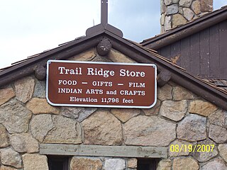
Trail Ridge Road is the name for the 48-mile (77 km) stretch of U.S. Highway 34 that traverses Rocky Mountain National Park from Estes Park, Colorado in the east to Grand Lake, Colorado in the west. Together with the connecting 6.9-mile (11 km) Beaver Meadow Road, Trail Ridge Road forms the 55-mile (89 km) Trail Ridge Road/Beaver Meadow National Scenic Byway, an All-American Road. With a high point at 12,183 feet (3,713 m) elevation, Trail Ridge Road is the highest continuous paved road in North America. The higher portion of Trail Ridge Road is closed from October to May.
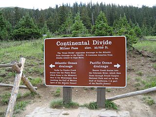
Milner Pass, elevation 10,759 ft (3,279 m) is a mountain pass in the Rocky Mountains of northern Colorado in the United States. It is located on the continental divide in the Front Range, within Rocky Mountain National Park, along the boundary between Larimer and Grand counties. The pass provides the passage over the continental divide for US 34, also known as Trail Ridge Road between Estes Park and Grand Lake. The pass is not, however, the high point on Trail Ridge Road, which crests at 12,183 ft (3,713 m) east of the pass within Rocky Mountain National Park. Along with the rest of Trail Ridge Road, the pass is generally closed in winter from the first heavy snow fall until the opening of the road around Memorial Day. The gentle pass divides the headwaters of the Cache la Poudre River and several creeks near the headwaters of the Colorado River to the west. The road near the pass provides a panoramic view of the Never Summer Mountains to the west.

Chickamauga and Chattanooga National Military Park, located in northern Georgia and southeastern Tennessee, preserves the sites of two major battles of the American Civil War: the Battle of Chickamauga and the Siege of Chattanooga. A detailed history of the park's development was provided by the National Park Service in 1998.

Prince William Forest Park is a national park in the U.S. state of Virginia within Prince William County, located adjacent to the Marine Corps Base Quantico near the town of Dumfries. Established as Chopawamsic Recreational Demonstration Area in 1936, the park is the largest protected natural area in the Washington, D.C. metropolitan region at over 13,000 acres (5,300 ha).
Fall River Pass is a mountain pass in northern Colorado, in the Rocky Mountains of the western United States. It is located in the Front Range, within Rocky Mountain National Park. The pass is traversed by U.S. Highway 34 on Trail Ridge Road between Granby and Estes Park. However, as at Milner Pass on the Continental Divide, the road does not descend after reaching the pass from the west, but instead continues to climb along a side ridge; thus, neither pass is the high point on Trail Ridge Road, which crests at 12,183 feet (3,713 m) elevation, east of Fall River Pass, still within Rocky Mountain National Park. On the other hand, the old, largely unpaved, and one-way-uphill Fall River Road does have its summit at Fall River Pass, where it joins the modern highway for the descent to the west.
The Trail Ridge Road/Beaver Meadow National Scenic Byway is a 55-mile (89 km) All-American Road and Colorado Scenic and Historic Byway located in Rocky Mountain National Park in Larimer and Grand counties, Colorado, USA. The byway consists of the 48-mile (77 km) Trail Ridge Road and the connecting 6.9-mile (11 km) Beaver Meadow Road. With a high point at 12,183 feet (3,713 m) elevation, Trail Ridge Road is the highest continuous paved road in North America. The higher portion of Trail Ridge Road is closed from October to May. The Rocky Mountain National Park Administration Building is a National Historic Landmark.

The Moraine Park Museum and Amphitheater, also known as the Moraine Park Lodge and the Moraine Park Visitor Center, are located in Moraine Park, a glaciated meadow between two moraines in Rocky Mountain National Park.

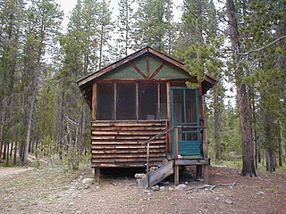
The Willow Park Patrol Cabin, also known as the Willow Park Ranger Station and the Willow Park Cook and Mess Hall, was built in Rocky Mountain National Park in 1923 to the design of members of the National Park Service Landscape Engineering Division under the supervision of Daniel Ray Hull. The cabin is an early example of the National Park Service Rustic style that was gaining favor with the Park Service. The cabin, along with the Willow Park Stable, originally accommodated maintenance crews on the Fall River Road.

The Fall River Pass Ranger Station in Rocky Mountain National Park was designed by National Park Service landscape architect Daniel Ray Hull in the National Park Service Rustic style. Built in 1922, the stone structure is similar in design to the Chasm Lake Shelter. Between 1933 and 1937 the ranger station was converted to a museum. The ranger station is associated with the construction of the nearby Trail Ridge Road. Located above the tree line, the building has a trap door in the roof to allow access when the door is blocked by drifting snow.

The Willow Park Stable in Rocky Mountain National Park was designed by National Park Service landscape architect Daniel Ray Hull and built in 1926. The National Park Service Rustic style stables and the nearby Willow Park Patrol Cabin were built to house crews maintaining the Fall River Road.
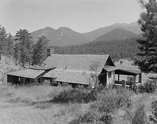
The William Allen White Cabins are chiefly associated with newspaper editor William Allen White, who adopted what would become Rocky Mountain National Park as his summer residence from 1912 to his death in 1944. White had visited Estes Park, Colorado while in college, and had previously summered in Colorado Springs. In 1912, White and his wife Sallie purchased an 1887 cabin near Estes Park. The Whites expanded it the next year and built a privy, studio, and two guest cabins.

The Fall River Entrance Historic District in Rocky Mountain National Park preserves an area of park administration buildings and employee residences built in the National Park Service Rustic style. The area is close to Estes Park, Colorado, at the original primary entrance to the east side of the park. The area includes the Bighorn Ranger Station, several houses, and some utility buildings. The buildings were designed in the 1920s and 1930s by the National Park Service Branch of Plans and Designs. Many of the 1930s buildings were built by Civilian Conservation Corps labor.

The Grand Ditch, also known as the Grand River Ditch and originally known as the North Grand River Ditch, is a water diversion project in the Never Summer Mountains, in northern Colorado in the United States. It is 14.3 miles (23.0 km) long, 20 feet (6.1 m) wide, and 3 feet (0.91 m) deep on average. Streams and creeks that flow from the highest peaks of the Never Summer Mountains are diverted into the ditch, which flows over the Continental Divide at La Poudre Pass at 10,175 feet (3,101 m), delivering the water into Long Draw Reservoir and the Cache La Poudre River for eastern plains farmers. The water would otherwise have gone into the Colorado River that flows west towards the Pacific; instead, the Cache La Poudre River goes East and through the Mississippi River discharges into the Gulf of Mexico.
The Holzwarth Historic District comprises a series of cabins built by the Holzwarth family as a guest ranch inholding within the boundaries of Rocky Mountain National Park, at Grand Lake, Colorado. The Holzwarths made their homestead in the Kawuneeche Valley in 1917, two years after the establishment of the park, and received a patent on the homestead in 1923. Guest ranch use began in 1919 and continued until the ranch was purchased by The Nature Conservancy in 1974. The property was transferred to the National Park Service in 1975 for incorporation into the park. The district comprises a number of rustic cabins on the Colorado River. Operations existed on both sides of the river, first known as the Holzwarth Trout Ranch and later as the Never Summer Ranch. All but Joe Fleshut's cabin have been removed from the east side of the river.

Kawuneeche Valley, also known as Kawuneeche or Coyote Valley, is a marshy valley of the Colorado River near its beginning. It is located on the west side of Rocky Mountain National Park in Colorado. The axis of the valley runs almost directly north to south. Kawuneeche means "valley of the coyote" in Arapaho language and there is a Coyote Valley Trail head by US Route 34 in the western half of the park. Coyotes still live here, as do wapiti (elk), mule deer, moose, and mountain lion.
Architects of the National Park Service are the architects and landscape architects who were employed by the National Park Service (NPS) starting in 1918 to design buildings, structures, roads, trails and other features in the United States National Parks. Many of their works are listed on the National Register of Historic Places, and a number have also been designated as National Historic Landmarks.
History of Rocky Mountain National Park began when Paleo-Indians traveled along what is now Trail Ridge Road to hunt and forage for food. Ute and Arapaho people subsequently hunted and camped in the area. In 1820, the Long Expedition, led by Stephen H. Long for whom Longs Peak was named, approached the Rockies via the Platte River. Settlers began arriving in the mid-1800s, displacing the Native Americans who mostly left the area voluntarily by 1860, while others were removed to reservations by 1878.


