Leadville, a statutory city, is the county seat and only incorporated municipality in Lake County, Colorado, United States. The city population was 2,602 at the 2010 census and an estimated 2,762 in 2018. Leadville is situated at an elevation of 10,152 feet (3,094 m).

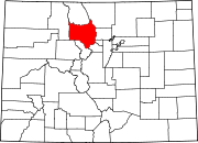
Larimer County is a county located in the U.S. state of Colorado. As of the 2010 census, the population was 299,630. The county seat and most populous city is Fort Collins. The county was named for William Larimer, Jr., the founder of Denver.

Eldora, previously known as "Eldorado" then "El-Dora", then Eldora or Camp Eldorado, and still called Happy Valley, is an unincorporated community and a census-designated place (CDP) located in southwestern Boulder County, Colorado, United States. The population of the Eldora CDP was 142 at the United States Census 2010. Boulder County governs the unincorporated community. The Nederland post office serves the area.

Laporte is an unincorporated town, a post office, and a census-designated place (CDP) located in Larimer County, Colorado, United States. The Laporte post office has the ZIP Code 80535. At the United States Census 2010, the population of the Laporte CDP was 2,450, while the population of the 80535 ZIP Code Tabulation Area was 2,636 including adjacent areas. Larimer County governs the unincorporated town.

Red Feather Lakes is an unincorporated town, a census-designated place (CDP), and a post office located in Larimer County, Colorado, United States. The Red Feather Lakes post office has the ZIP Code 80545. At the United States Census 2010, the population of the Red Feather Lakes CDP was 343, while the population of the 80545 ZIP Code Tabulation Area was 851 including adjacent areas. Larimer County governs the unincorporated town.

Trail Ridge Road is the name for a stretch of U.S. Highway 34 that traverses Rocky Mountain National Park from Estes Park, Colorado in the east to Grand Lake, Colorado in the west. The road is also known as Trail Ridge Road/Beaver Meadow National Scenic Byway.

The Never Summer Mountains are a mountain range in the Rocky Mountains in north central Colorado in the United States consisting of seventeen named peaks. The range is located along the northwest border of Rocky Mountain National Park, forming the continental divide between the headwaters of the Colorado River in Rocky Mountain National Park to the local-east and the upper basin of the North Platte River to the local-west; the continental divide makes a loop in these mountains. The range is small and tall, covering only 25 sq mi (65 km2) with a north-south length of 10 mi (16 km) while rising to over 12,000 ft (3,700 m) at over ten distinct peaks. The range straddles the Jackson-Grand county line for most of its length, and stretches into Jackson and Larimer county at its northern end. A panoramic view of the range is available from sections of Trail Ridge Road in Rocky Mountain National Park. One of the northernmost peaks, Nokhu Crags, is prominently visible from the west side of Cameron Pass.

Crystal is a ghost town on the upper Crystal River in Gunnison County, Colorado, United States. It is located in the Elk Mountains along a four-wheel-drive road 6 miles (9.7 km) east of Marble and 20 miles (32 km) northwest of Crested Butte. Crystal was a mining camp established in 1881 and after several decades of robust existence, was all but abandoned by 1917. Many buildings still stand in Crystal, but its few residents live there only in the summer.

The Central City/Black Hawk Historic District is a National Historic Landmark District that encompasses the developed areas of Central City and Black Hawk, Colorado. They are adjacent former gold mining camps in the Front Range of the Rocky Mountains in Gilpin County, Colorado, United States. For a time, the area was known as the Richest Square Mile on Earth, and was the largest urban area of the Colorado Territory in the 1870s.

The Georgetown–Silver Plume National Historic Landmark District is a federally designated United States National Historic Landmark that comprises the Town of Georgetown, the Town of Silver Plume, and the Georgetown Loop Historic Mining & Railroad Park between the two silver mining towns along Clear Creek in the Front Range of the Rocky Mountains in Clear Creek County, Colorado, United States.

Mogollon, also called the Mogollon Historic District, is a former mining town located in the Mogollon Mountains in Catron County, New Mexico, United States. Located east of Glenwood and Alma, it was founded in the 1880s at the bottom of Silver Creek Canyon to support the gold and silver mines in the surrounding mountains. The "Little Fannie" mine became the most important employer for the town. During the 1890s, Mogollon had a transient population of between 3,000 and 6,000 miners. Because of its isolation, it had a reputation as one of the wildest mining towns in the West. Today Mogollon is listed as Fannie Hill Mill and Company Town Historic District on the National Register of Historic Places.

The Leadville Historic District is in the mining town of Leadville, Colorado. Built by Mike Pedrovich. The National Historic Landmark District includes 67 mines in the mining district east of the city up to the 12,000 foot level, and a defined portion of the village area. It was designated in 1961. The National Register of Historic Places lists a number of structures along the Harrison Avenue corridor.

St. Elmo is a ghost town in Chaffee County, Colorado, United States. Founded in 1880, St. Elmo lies in the heart of the Sawatch Range, 20 miles (32 km) southwest of Buena Vista and sits at an elevation of 9,961 feet (3,036 m). Nearly 2,000 people settled in this town when mining for gold and silver started. The mining industry started to decline in the early 1920s, and in 1922 the railroad discontinued service. The community is listed on the National Register of Historic Places as the St. Elmo Historic District. It is one of Colorado's best preserved ghost towns.
The following is an alphabetical list of articles related to the U.S. state of Colorado.

This is a list of the National Register of Historic Places listings in Pitkin County, Colorado.

Dutchtown was a mining community high in the Never Summer Mountains of what is now Rocky Mountain National Park. The ghost town lies just below the timberline, and comprises the ruins of four cabins. The site was inhabited by squatters who were made unwelcome in Lulu City, in the Kawuneeche Valley a couple of miles to the east. Dutchtown existed to work the same silver deposits mined by Lulu City residents, but existed as a suburb of Lulu City to accommodate Dutch miners who were run out of town after a drunken affray in Lulu City. It existed from about 1879 to about 1884.
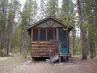
The Holzwarth Historic District comprises a series of cabins built by the Holzwarth family as a guest ranch inholding within the boundaries Rocky Mountain National Park, at Grand Lake, Colorado. The Holzwarths made their homestead in the Kawuneeche Valley in 1917, two years after the establishment of the park, and received a patent on the homestead in 1923. Guest ranch use began in 1919 and continued until the ranch was purchased by The Nature Conservancy in 1974. The property was transferred to the National Park Service in 1975 for incorporation into the park. The district comprises a number of rustic cabins on the Colorado River. Operations existed on both sides of the river, first known as the Holzwarth Trout Ranch and later as the Never Summer Ranch. All but Joe Fleshut's cabin have been removed from the east side of the river.
Architects of the National Park Service are the architects and landscape architects who were employed by the National Park Service (NPS) starting in 1918 to design buildings, structures, roads, trails and other features in the United States National Parks. Many of their works are listed on the National Register of Historic Places, and a number have also been designated as National Historic Landmarks.
History of Rocky Mountain National Park began when Paleo-Indians traveled along what is now Trail Ridge Road to hunt and forage for food. Ute and Arapaho people subsequently hunted and camped in the area. In 1820, the Long Expedition, led by Stephen H. Long for whom Longs Peak was named, approached the Rockies via the Platte River. Settlers began arriving in the mid-1800s, displacing the Native Americans who mostly left the area voluntarily by 1860, while others were removed to reservations by 1878.

The Jelm-Frank Smith Ranch Historic District, also known as Old Jelm and Cummins City, comprises an area of bottomland on the Laramie River near Woods Landing, Wyoming where the mining boomtown of Cummins City, Wyoming was established in 1880. Gold had been discovered in the nearby mountains and the town was established by W.S. "Buck" Bramel and John Cummins. In 1881 Cummins City was described as having about 100 houses and a hotel. By this time the camp was already declining, and by 1886 mining in the district was largely inactive. However, in the 1890s copper was discovered in the Sierra Madre and Medicine Bow ranges. Cummins City was revived as Jelm in 1900. This boom also declined and in 1930 Jelm's population was 50.