Falls Church Airpark

Last updated
Falls Church Airpark (closed)
FallsChurchAirpark USGS Topo 1955.JPG
USGS Topographic Map, 1955
Summary
Airport typeGeneral aviation
OwnerFalls Church Airpark, Inc.
OperatorAshby Rossen
ServesMetropolitan Washington D.C.
LocationFairfax County, Virginia
Elevation  AMSL 250 ft / 76 m
Coordinates 38°51′54″N77°11′48″W / 38.86500°N 77.19667°W / 38.86500; -77.19667
Map
USA Virginia Northern location map.svg
Airplane silhouette.svg
Location of Falls Church Airpark
USA Virginia location map.svg
Airplane silhouette.svg
(Virginia)
Usa edcp location map.svg
Airplane silhouette.svg
(the United States)
Runways
Direction LengthSurface
ftm
9/272,650808dirt

Falls Church Airpark was an airport located in the Falls Church area of Fairfax County, Virginia from 1945 to 1961. The facility was located on a parcel of land owned by Eakin Properties, a Virginia real estate development firm. [1] The airport was primarily used for general aviation and civil defense purposes until encroaching residential development forced its closure. The area formerly occupied by the airport is now mainly used as a shopping center with the western end of the complex occupied by the Thomas Jefferson branch of the Fairfax County Public Library system. Parts of several apartment complexes are also located on some of the airport's former grounds. [2] [3]

Contents

History and usage

The Falls Church Airpark was a pair of unpaved landing strips located in Fairfax County, Virginia. The license for the airport was granted by the Commonwealth of Virginia on July 25, 1945 [4] but the airport was not available for general use until 1946 when it opened with a single grass runway, 2,650' long. The airport was built on an area known at the time as "Eisenhower's Farm" and was located alongside U.S. Route 50. [3] [5] A 1949 report, compiled by the state of Virginia, described the airport as being located two miles southwest of Falls Church, and featuring a single strip that was characterized as "...poorly graded and hazardous after rains." [6] By 1951, a smaller, crosswind airstrip was added to the complex. During the 1950s, the airport was used by general aviation, civil defense, medical transportation, and air shows. [7] [8] [9] [10] Pilot training was also offered at the facility [11] and airplane sales and rentals were made available through a Mooney aircraft dealer located on the property. The airpark also hosted a chapter of the Civil Air Patrol squadron, private flying clubs, a small building that contained a Link Trainer for student pilot use, a hangar used for maintenance work, and a converted house that was used as both an office and a snack bar complete with vending machines. [12] Despite the difficulties in landing and taking off due to the slope of the main runway and the restricting tree lines at the field's western end, the airfield was popular with local pilots and at its peak hosted approximately 75 planes. [2]

The airport's popularity during the 1950s led to a feature article in the August 7, 1955 edition of the Sunday Washington Post newspaper. The article discussed the activities of the NBC flying club whose founding members worked for the broadcast network's Washington, D.C. affiliate. Totaling 17 members, the club was not restricted to NBC employees and included local area residents. Several of the members interviewed stated that they flew their families to Rehoboth Beach, Florida, and other vacation areas. The article stressed the club members' opinion that the club's flying activities were very affordable compared to commercial air travel or traveling by car. At the time of the article, the club's assets included a four-seat Cessna 170 and a single seat Mooney. [13]

Significant events

Falls Church Airpark, circa 1950. The road at the top of the photo is U.S Route 50 (Arlington Blvd) Falls Church Airpark 1951 USGS aerial view.jpg
Falls Church Airpark, circa 1950. The road at the top of the photo is U.S Route 50 (Arlington Blvd)
Falls Church Airpark hosted many events including this 1949 air show. Poster courtesy of Abandoned & Little-Known Airfields FallsChurch VA 49AirFair.jpg
Falls Church Airpark hosted many events including this 1949 air show. Poster courtesy of Abandoned & Little-Known Airfields

Closure and aftermath

As early as 1956, Eakin Properties, Inc., the owners of the airport's land, had attempted to convert the facility to commercial use. Led by Leroy Eakin, the company had a significant presence in Northern Virginia and had been largely responsible, years earlier, in extending U.S. Route 50 through the parts of Fairfax County where Eakin had purchased over 1,500 acres of real estate for as little as $10 an acre decades earlier. [1] [27] Concerned that a shopping center would lead to traffic problems, the county denied Eakin the permit. [28] After several more years of airport operations, Eakin Properties was named in a July 1960 grand jury indictment charging that the airfield's operation constituted a public nuisance. Neighbors charged that "airplanes taking off and landing raised dust that polluted the air and caused great annoyance inconvenience, and discomfort." [29] Eakin subsequently applied to the county for permission to build apartment complexes on the site of the airfield. On at least two occasions, the applications were denied due to local opposition and concerns regarding the lack of adequate sewage infrastructure needed to support the 832 unit complex proposed by Eakin. [30] [31] Although the airport was still running classified advertisements in the Washington Post as late as August 6, 1960, [32] Eakin eventually succeeded in developing the airport into a shopping center and by 1961 the Falls Church Airpark was no longer shown as an active airfield on the Washington D.C. aeronautical sectional. [2] The shopping center that finally occupied the bulk of the airports former grounds was called "Loehmann's Plaza" [33] and as of 2016 is still in existence, now bearing the name "Graham Park Plaza". [34] in 2022, construction began on a community of 172 townhomes located on a parcel of Graham Park Plaza that previously hosted a number of retail shops. Townhome sales started in 2023, In recognition of the air park, the builder used aviation terms for several of the roads in the complex, the main thoroughfare called "Old Airfield Lane." [35]

See also

Related Research Articles

<span class="mw-page-title-main">Capital Airlines (United States)</span> Defunct air carrier

Capital Airlines was an airline serving the eastern, southern, southeastern, and midwestern United States. Capital's headquarters were located at Washington National Airport across the Potomac river from Washington, D.C., where crew training and aircraft overhauls were also accomplished. In the 1950s Capital was the fifth largest United States domestic carrier by passenger count after the Big Four air carriers.

<span class="mw-page-title-main">Floyd Bennett Memorial Airport</span> Airport in Queensbury, New York

Floyd Bennett Memorial Airport is a county-owned, public-use airport in Warren County, New York, United States. It is located three nautical miles (6 km) northeast of the central business district of Glens Falls, in the town of Queensbury. This airport is included in the National Plan of Integrated Airport Systems for 2011–2015, which categorized it as a general aviation facility.

<span class="mw-page-title-main">Ardmore Airport (New Zealand)</span> Airport in Auckland

Ardmore Airport is an airport 3 nautical miles (5.5 km) southeast of Manurewa in Auckland, New Zealand.

<span class="mw-page-title-main">Katama Airpark</span> Airport in Edgartown, Massachusetts

Katama Airpark is a public airport in the Katama section of Edgartown, Massachusetts, in Dukes County on the island of Martha's Vineyard. The airport, owned by the Town of Edgartown, has three runways, averages 22 takeoffs and landings per day, and has one aircraft based on its field.

<span class="mw-page-title-main">Washington-Virginia Airport</span> Former airport located in Fairfax County, Virginia

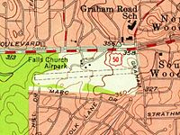
Washington-Virginia Airport was an airport that was located in Fairfax County, Virginia from 1947 to 1970. The airport was mainly used for general aviation purposes until encroaching residential and commercial activities forced its closure.

<span class="mw-page-title-main">Lunken Airport</span> Airport

Cincinnati Municipal Airport – Lunken Field is a public airport in Cincinnati, Ohio, three miles (5 km) east of Downtown Cincinnati. It is owned by the city of Cincinnati and serves private aircraft, including the fleets of local corporations. It serves a few commercial flights and is the second-largest airport serving Cincinnati after Cincinnati/Northern Kentucky International Airport, which is the area’s primary airport. It is known as Lunken Airport or Lunken Field, after Eshelby Lunken. It is bounded by US Route 50 to the west, US Route 52 and the Ohio River to the south, the Little Miami River to the east, and Ohio Route 125 to the north. The airport is headquarters and hub for Cincinnati-based public charter airline Ultimate Air Shuttle, serving 5 destinations in the eastern United States with 16 peak daily flights. Lunken is also home to small charter airline Flamingo Air and its aviation school.

<span class="mw-page-title-main">Montgomery County Airpark</span> Public airport in Montgomery County, Maryland, United States

Montgomery County Airpark is a U.S. public airport located three miles (5 km) northeast of the city of Gaithersburg, in Montgomery County, Maryland, United States.

<span class="mw-page-title-main">Fallbrook Community Airpark</span> Airport

Fallbrook Community Airpark, also known as Fallbrook Airpark, is a county-owned public-use airport located two nautical miles south of the central business district of Fallbrook, in San Diego County, California, United States.

Air Park-Dallas Airport is a public airport located 16 nautical miles (30 km) northwest of the central business district of Dallas, in Collin County, Texas, United States. The airport is used solely for general aviation purposes. It was built as an airpark-style development, with adjacent homeowners having perpetual runway access guaranteed by restrictive covenants, but no formal ownership or management interest in the physical airfield facilities. The airport was formerly within the city limits of Hebron, Texas but was annexed by the city of Carrollton in 2008; the nearby residential lots were not included in the annexation.

<span class="mw-page-title-main">Zamperini Field</span> Airport in Torrance, California, US

Zamperini Field is a public airport three miles (5 km) southwest of downtown Torrance, in Los Angeles County, California, United States.

<span class="mw-page-title-main">Harold Geiger</span> American aviator

Major Harold Geiger was US military aviator number 6, who was killed in an airplane crash in 1927. He was also a balloonist. Spokane International Airport is designated with the International Air Transport Association airport code GEG in his memory.

<span class="mw-page-title-main">Bakers Creek air crash</span>

The Bakers Creek air crash was an aviation disaster that occurred on 14 June 1943, when a United States Army Air Forces (USAAF) Boeing B-17 Flying Fortress aircraft crashed at Bakers Creek, Queensland, Australia. The aircraft took off from Mackay and crashed approximately 8 km south of the airfield. Forty military service personnel on board were killed; one person survived the crash. The crash is Australia's deadliest aviation disaster by death toll and was the deadliest accident involving a transport aircraft in the south-western Pacific during World War II.

This is a partial list of accidents and incidents involving the Boeing-designed B-17 Flying Fortress. Combat losses are not included except for a very few cases denoted by singular circumstances. A few documented drone attrition cases are also included.

<span class="mw-page-title-main">Cornelia Fort Airpark</span> Airport

Cornelia Fort Airpark was a privately owned, public-use airport located five nautical miles northeast of the central business district of Nashville, in Davidson County, Tennessee, United States. It is named in honor of Nashvillian, Cornelia Fort, the first female pilot to be killed on war duty in American history. The airpark was built in 1945 near her family farm. The 141-acre airport was located on part of a plot of land granted to early Nashvillian Ephraim McLean for service in the Revolutionary War, near what is still known as McLean's Bend in the Cumberland River in East Nashville. The airport operated from 1944 until 2011, when the city of Nashville acquired it to include it as non-aviation part of Shelby Park.

Braintree Airport was an airport located in the town of Braintree, Massachusetts from 1948 to 1968. The airport was used for general aviation purposes until encroaching residential development forced its closure.

Andrews University Airpark is a privately owned, public use airport located 2 miles west of Berrien Springs, Michigan. It is owned and managed by Andrews University, a Seventh Day Adventist university that manages an aviation department.

References

  1. 1 2 Bredemeler, Brandon (November 9, 1970) "At 95 Former Va. Realtor Still Donates to Build Park" The Washington Post, page C1
  2. 1 2 3 Freeman, Paul "Falls Church Airpark, Falls Church, VA" Abandoned & Little-Known Airfields. Retrieved March 19, 2014
  3. 1 2 Rollo, Vera (2003) Virginia Airports : A Historical Survey of Airports and Aviation From the Earliest Days. Richmond, VA: Virginia Aviation Historical Society Archived 2015-07-23 at the Wayback Machine
  4. "Annual Report of the State Corporation Commission of Virginia. Compilations from Returns of Railroads, Canals, Electric Railways and Other Corporate Companies, Volume 58" (1945) Virginia State Corporation Commission, page 32
  5. Staff writer (July 25, 1945) "Airfield Plan Weighed" The Washington Post, page 3
  6. "Division of Aeronautics, State Corporation Commission" (1949) Virginia State Corporation Commission, pages 50-51
  7. 1 2 Staff writer (December 15, 1952) "Disaster Teams Swarm in Falls Church as Imaginary Atom Bomb Drops on Airport" The Washington Post, page 3
  8. 1 2 Staff writer (December 14, 1952) "Mock Air Raid Today in Fairfax" The Washington Post, page M8
  9. Staff writer (July 10, 1950) "Here's a Model Speed Demon" The Washington Post, page B2
  10. Staff writer (April 10, 1953) "Weekly Blood Flights" The Washington Post, page10
  11. 1 2 Staff writer (December 1, 1947) "Student Pilot Hurt in Crash at Falls Church" The Washington Post, page B2
  12. Staff writer (June 17, 1950) "Washington-National Airport Now Has 150 Vending Machines" The Billboard, page 110. Retrieved March 21, 2014
  13. Cheshire, Maxine (August 7, 1955) They're Flying High - At Low Cost" The Washington Post, pages F7 & F12
  14. Staff writer (September 4, 1947) "Man, Woman Perish in Air Crash" The Washington Post, page 1
  15. 1 2 Staff writer (September 5, 1947) "Woman Pilot Seriously Injured In Crash Near Falls Church" The Washington Post, page B1
  16. Staff writer (September 6, 1947) "CAB Begins Full Probe of 2 Va. Crashes" The Washington Post, page B2
  17. Staff writer (August 27, 1951) "Kids of All Ages in Air Show at Falls Church" The Washington Post, page B1
  18. Staff writer (November 5, 1951) "4 Men Escape Serious Injury In Plane Crash at Falls Church" The Washington Post, page 1
  19. Staff writer (June 17, 1952) "Woman Flier Injured as Plane Noses Over" The Washington Post, page 22
  20. Staff writer (November 17, 1952) "Air Force Plane is Forced Down at Falls Church" The Washington Post, page 1
  21. Staff writer (December 5, 1952) "Air Raid Sunday in Falls Church" The Washington Post, page 26
  22. Staff writer (June 29, 1953) "District Office Machine Broker Crashed When His Motor Fails" The Washington Post, page 1
  23. Staff writer (October 26, 1953) "Two Flee Forest Fire After Crash" The Washington Post, page 1
  24. Staff writer (February 28, 1954) "Plane Crash Kills 2 Men; 5 Children Imperiled -- Craft Pancakes Into Annandale Backyard Where Girls Are Playing" The Washington Post, page M1
  25. Staff writer (January 7, 1960) "Blaze Destroys Planes, hangar" The Washington Post, page A1
  26. McBee, Susanna (January 17, 1960) "Pilot Wrecks Light Plane Landing in County Street" The Washington Post, page B4
  27. Bonner, Alice (April 20, 1972) "Developer Leroy Eakins Dies" The Washington Post, page B6
  28. "Fairfax Board Rejects Shopping Center Plea". The Washington Star . April 26, 1956. Retrieved January 23, 2021.
  29. Staff writer (July 20, 1960) "Rock Quarrying Firm Indicted as Nuisance" The Washington Post, page C2
  30. Staff writer (November 22, 1960) "Zone Shift in Fairfax is Deferred" The Washington Post, page B2
  31. Staff writer (December 20, 1960) "Fairfax Rejects Rezoning Plea" The Washington Post, page B8
  32. Classified advertisement (August 6, 1960) "Aviation - 115" The Washington Post, page C10
  33. Day, Kathleen (September 21, 1987) "Small Airports Nosediving in Number" The Washington Post, page B1
  34. Cole, Sally (September 17, 2014). "Loehmann's Plaza Gets Name Change". Falls Church News-Press . Retrieved January 23, 2021.
  35. Tankersley, Benjamin C. "172-townhouse community rising in Falls Church, Va". The Washington Post . Retrieved 4 December 2023.