Frodingham, Lincolnshire

Last updated

Frodingham
North Lincolnshire Museum-by-fred-roberts.jpg
North Lincolnshire Museum
Lincolnshire UK location map.svg
Red pog.svg
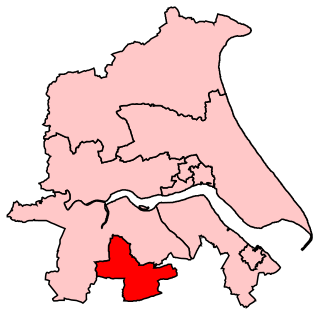
Frodingham
Location within Lincolnshire
OS grid reference SE892117
  London 145 mi (233 km)  S
District
Shire county
Region
Country England
Sovereign state United Kingdom
Post town Scunthorpe
Postcode district DN15
Police Lincolnshire
Fire Lincolnshire
Ambulance East Midlands
UK Parliament
List of places
UK
England
Lincolnshire
53°35′40″N0°39′09″W / 53.594500°N 0.6526°W / 53.594500; -0.6526

Frodingham is a historic hamlet and now a suburb of Scunthorpe in the borough of North Lincolnshire, in Lincolnshire, England. The village lay directly to the south of Scunthorpe town centre, the name Frodingham is now often used to refer to the area directly to the north of the town centre.

Contents

Frodingham parish originally included the townships of Frodingham, Scunthorpe, Brumby, Crosby (part) and Gunness (part). [1] [2] The townships became civil parishes in 1866. In 1894 Brumby & Frodingham Urban District Council (UDC) was formed, separate from neighbouring Scunthorpe UDC. Brumby & Frodingham UDC was amalgamated with Scunthorpe in 1919. [3]

St Lawrence's church was the centre of the original hamlet of Frodingham. Frodingham township and civil parish, sandwiched between Scunthorpe to the north and Brumby to the south, was 5 miles long and 1/4 mile wide. It ran from the Trent in the west, across the Lincoln Cliff, through the hamlet itself and across to Bottesford Beck in the east. [4] It was here in the east end of the township that large deposits of ironstone began to be exploited in the mid 19th century: the Frodingham, North Lincolnshire and Redbourn Hill ironworks were established, and workers' cottages were built either side of Rowland Road, in an area then known as New Frodingham. [4]

In modern times, the name Frodingham is now used to refer to the area around Frodingham Road in Crosby, and online maps reflect this usage. [5]

The Trent, Ancholme and Grimsby Railway ran through the township, and the railway station was next to the Frodingham ironworks. The first Frodingham railway station was opened in 1866; the second station was opened in 1886, and closed in 1926. [6]

In 1912, the Frodingham Ironworks was taken over by the Appleby Ironworks to form the Appleby-Frodingham Steel Company.

The North Lincolnshire Museum is in the former village vicarage, built in 1874 on the site of Frodingham Hall.

St Lawrence's Church Church of St. Lawrence, Scunthorpe - geograph.org.uk - 586834.jpg
St Lawrence's Church

Frodingham Grade I listed Anglican church is dedicated to St Lawrence. [7] [8] Originating from the 12th century, it was rebuilt in 1841 except for the Early English-style tower. [9] In 1916 Cox recorded a Carolean altar table, dated 1635. [9] It contains memorials to the Healy family who added several windows within the church. [10]

The vicar of Frodingham from 1655 to 1660 was John Ryther [11] (c1638-1681). At the Restoration he was deprived of his living here and moved to Brough and was deprived again in 1662. After setting up Kipping Chapel near Bradford and some time in prison, he moved to London and began one of the first missions amongst seamen at Wapping in 1669. Due to his emotional preaching style, he was often known as 'Crying Jeremy.' [12]

In 1885 Kelly's Directory reported a large temperance hall, built in 1871, that also housed a library and newspaper reading room. Chief crops grown in the area were wheat, barley and potatoes. [10]

In 1911 the civil parish had a population of 1734. [13] On 1 October 1919 the parish was abolished to form "Scunthorpe and Frodingham" and Brumby Rural. [14]

See also

Related Research Articles

<span class="mw-page-title-main">North Lincolnshire</span> Borough in Lincolnshire, England

North Lincolnshire is a unitary authority area with borough status in Lincolnshire, England. At the 2011 Census, it had a population of 167,446. The administrative centre and largest settlement is Scunthorpe, and the borough also includes the towns of Brigg, Broughton, Haxey, Crowle, Epworth, Bottesford, Winterton, Kirton in Lindsey and Barton-upon-Humber. North Lincolnshire is part of the Yorkshire and the Humber region.

<span class="mw-page-title-main">Scunthorpe</span> Industrial town in Lincolnshire, England

Scunthorpe is an industrial town in the North Lincolnshire district of Lincolnshire, England. It is Lincolnshire's third most populous settlement, after Lincoln and Grimsby, with a population of 81,286 in 2021.

<span class="mw-page-title-main">Metropolitan Borough of Stepney</span> Metropolitan borough in the County of London

The Metropolitan Borough of Stepney was a Metropolitan borough in the County of London created in 1900. In 1965 it became part of the London Borough of Tower Hamlets.

<span class="mw-page-title-main">Henbury, Bristol</span> Human settlement in England

Henbury is a suburb of Bristol, England, approximately 5 miles (8.0 km) north west of the city centre. It was formerly a village in Gloucestershire and is now bordered by Westbury-on-Trym to the south; Brentry to the east and the Blaise Castle Estate, Blaise Hamlet and Lawrence Weston to the west. To the north lie the South Gloucestershire village of Hallen and the entertainment/retail park Cribbs Causeway.

<span class="mw-page-title-main">Althorpe</span> Village in North Lincolnshire, England

Althorpe is a small village and former civil parish, now in the parish of Keadby with Althorpe, in the North Lincolnshire district, in the ceremonial county of Lincolnshire, England. It is four miles (6 km) west of Scunthorpe and the same distance south-east of Crowle, on the A18 road.

<span class="mw-page-title-main">Scunthorpe (UK Parliament constituency)</span> Parliamentary constituency in the United Kingdom

Scunthorpe is a constituency represented in the House of Commons of the UK Parliament since 2019 by Holly Mumby-Croft, a member of the Conservative Party, when she gained the seat from the Labour Party.

<span class="mw-page-title-main">A1077 road</span> Road in North Lincolnshire

The A1077 road runs through North Lincolnshire, England, between Scunthorpe and South Killingholme.

<span class="mw-page-title-main">Rowland Winn, 1st Baron St Oswald</span> English industrialist and Conservative politician

Rowland Winn, 1st Baron St Oswald was an English industrialist and Conservative Party politician.

<span class="mw-page-title-main">North Frodingham</span> Village and civil parish in the East Riding of Yorkshire, England

North Frodingham is a village and civil parish in the East Riding of Yorkshire, England. It is situated approximately 5.5 miles (9 km) south-east of the town of Driffield and lies on the B1249 road.

<span class="mw-page-title-main">Gunness</span> Village and civil parish in North Lincolnshire, England

Gunness is a village and civil parish in North Lincolnshire, England. It is situated 3 miles (5 km) west from Scunthorpe, and on the east bank of the River Trent. The population of the civil parish at the 2011 census was 2,462.

Frodingham railway station was a railway station in Frodingham, Lincolnshire, England. It was open by the Trent, Ancholme, and Grimsby Railway on 1 October 1866 and, like all the others built by that company, had staggered platforms set around the level crossing on the Brigg Road. The first station here was closed in autumn 1886, when a new Frodingham station, built by the Manchester, Sheffield and Lincolnshire Railway, was opened, to the west of the Brigg Road level crossing. This station was suffixed "and Scunthorpe" at some date and was closed in 1928, when the LNER opened a new station which it named Scunthorpe nearer to the town centre.

Frodingham may refer to:

<span class="mw-page-title-main">Long Marton</span> Human settlement in England

Long Marton is a village and civil parish in the Eden District of the English county of Cumbria. In 2011 the population was 827.

Crosby was a small hamlet in Lincolnshire which has grown into a suburb in the north of Scunthorpe, North Lincolnshire. Remnants of the old hamlet can be found in Old Crosby.

<span class="mw-page-title-main">Scunthorpe General Hospital</span> Hospital in North Lincolnshire, United Kingdom

Scunthorpe General Hospital is the main hospital for North Lincolnshire. It is situated on Church Lane in the west of Scunthorpe, off Kingsway, and north of the railway.

<span class="mw-page-title-main">Walkerith</span> Hamlet in Lincolnshire, England

Walkerith is a hamlet within the civil parish of East Stockwith, in the West Lindsey district of Lincolnshire, England. It lies on the east bank of the River Trent, 2.5 miles (4.0 km) north-west from Gainsborough and 1.5 miles (2.4 km) south from East Stockwith.

<span class="mw-page-title-main">Scunthorpe Steelworks</span> Industrial complex in northern England

The Iron and Steel Industry in Scunthorpe was established in the mid 19th century, following the discovery and exploitation of middle Lias ironstone east of Scunthorpe, Lincolnshire, England.

<span class="mw-page-title-main">Beighton, South Yorkshire</span> Village in South Yorkshire, England

Beighton is a village 6 miles south-east of Sheffield's city centre, now classed as a historic township of the city. Due to much expansion, the village became a part of Sheffield city in 1967, and was transferred from Derbyshire to the newly created South Yorkshire, England. During much of the late 17th to 19th centuries the village was noted for its edge tool manufacturing, with Thomas Staniforth & Co Sickle works being based at nearby Hackenthorpe.

<span class="mw-page-title-main">Borough of Scunthorpe</span> Former district in Humberside, England

Scunthorpe was a non-metropolitan district of Humberside from 1974 to 1996, urban district from 1894 to 1919 and a municipal borough from 1936 to 1974 in the Parts of Lindsey, Lincolnshire, England.

References

  1. "History of Frodingham in North Lincolnshire | Map and description". www.visionofbritain.org.uk.
  2. "Genuki: Frodingham, Lincolnshire".
  3. "Frodingham CP/AP through time | Census tables with data for the Parish-level Unit". www.visionofbritain.org.uk.
  4. 1 2 "View map: Ordnance Survey, Lincolnshire XVIII.NE (includes: Scunthorpe.) - Ordnance Survey Six-inch England and Wales, 1842-1952". maps.nls.uk.
  5. "Side by side georeferenced maps viewer – Map images – National Library of Scotland".
  6. Butt, R. V. J. (October 1995). The Directory of Railway Stations: details every public and private passenger station, halt, platform and stopping place, past and present (1st ed.). Sparkford: Patrick Stephens Ltd. ISBN   978-1-85260-508-7. OCLC   60251199. OL   11956311M.
  7. Historic England. "Church of St Lawrence (1083610)". National Heritage List for England . Retrieved 3 August 2011.
  8. St Lawrence, Frodingham, Ourchurchweb.org.uk
  9. 1 2 Cox, J. Charles (1916) Lincolnshire p. 123; Methuen & Co. Ltd
  10. 1 2 Kelly's Directory of Lincolnshire with the port of Hull 1885, p. 400
  11. The Publications of the Lincoln Record Society, Volume 38, p.xii
  12. Charles Brears, 'Lincolnshire in the 17th and 18th Centuries', 1940, p. 37
  13. "Population statistics Frodingham CP/AP through time". A Vision of Britain through Time . Retrieved 2 May 2024.
  14. "Glanford Brigg Registration District". UKBMD. Retrieved 2 May 2024.