Godney

Last updated

Godney
Godney Church - geograph.org.uk - 675568.jpg
Godney Church
Pill Box in Upper Godney - geograph.org.uk - 676444.jpg
Pill Box in Upper Godney
Somerset UK location map.svg
Red pog.svg
Godney
Location within Somerset
Population237 (2011) [1]
OS grid reference ST485425
District
Shire county
Region
Country England
Sovereign state United Kingdom
Post town GLASTONBURY
Postcode district BA5
Dialling code 01458
Police Avon and Somerset
Fire Devon and Somerset
Ambulance South Western
UK Parliament
List of places
UK
England
Somerset
51°10′51″N2°44′21″W / 51.1807°N 2.7393°W / 51.1807; -2.7393 Coordinates: 51°10′51″N2°44′21″W / 51.1807°N 2.7393°W / 51.1807; -2.7393

Godney is a village and civil parish near Glastonbury on the River Sheppey on the Somerset Levels in the Mendip district of Somerset, England.

Contents

History

Near the village are the sites of the Iron Age Glastonbury Lake Village, and the now drained Meare Pool.

During the Second World War, Godney was incorporated into the GHQ Line. Several pillboxes were constructed in the area. Natural obstacles to tanks were supplemented with an anti-tank ditch and bridges in the area were prepared for demolition at short notice. [2]

Governance

The parish council has responsibility for local issues, including setting an annual precept (local rate) to cover the council's operating costs and producing annual accounts for public scrutiny. The parish council evaluates local planning applications and works with the local police, district council officers, and neighbourhood watch groups on matters of crime, security, and traffic. The parish council's role also includes initiating projects for the maintenance and repair of parish facilities, as well as consulting with the district council on the maintenance, repair, and improvement of highways, drainage, footpaths, public transport, and street cleaning. Conservation matters (including trees and listed buildings) and environmental issues are also the responsibility of the council.

The village falls within the Non-metropolitan district of Mendip, which was formed on 1 April 1974 under the Local Government Act 1972, having previously been part of Wells Rural District, [3] which is responsible for local planning and building control, local roads, council housing, environmental health, markets and fairs, refuse collection and recycling, cemeteries and crematoria, leisure services, parks, and tourism.

Somerset County Council is responsible for running the largest and most expensive local services such as education, social services, libraries, main roads, public transport, policing and fire services, trading standards, waste disposal and strategic planning.

It is also part of the Wells county constituency represented in the House of Commons of the Parliament of the United Kingdom. It elects one Member of Parliament (MP) by the first past the post system of election.

Geography

River Sheppey in Upper Godney, facing east. River Sheppey in Upper Godney - facing east - geograph.org.uk - 676468.jpg
River Sheppey in Upper Godney, facing east.

To the north west of the village are the Westhay Moor and Somerset Levels National Nature Reserves. Westhay Moor is a biological Site of Special Scientific Interest and part of the Somerset Levels and Moors Special Protection Area under the EU Birds Directive and as a Ramsar site, and a national nature reserve. [4] It is part of the Brue Valley Living Landscape conservation project.

Along with the rest of South West England, Godney has a temperate climate which is generally wetter and milder than the rest of the country. [5] The annual mean temperature is approximately 10  °C (50.0  °F ). Seasonal temperature variation is less extreme than most of the United Kingdom because of the adjacent sea temperatures. The summer months of July and August are the warmest with mean daily maxima of approximately 21 °C (69.8 °F). In winter mean minimum temperatures of 1 °C (33.8 °F) or 2 °C (35.6 °F) are common. [5] In the summer the Azores high pressure affects the south-west of England, however convective cloud sometimes forms inland, reducing the number of hours of sunshine. Annual sunshine rates are slightly less than the regional average of 1,600 hours. [5] In December 1998 there were 20 days without sun recorded at Yeovilton. Most of the rainfall in the south-west is caused by Atlantic depressions or by convection. Most of the rainfall in autumn and winter is caused by the Atlantic depressions, which is when they are most active. In summer, a large proportion of the rainfall is caused by sun heating the ground leading to convection and to showers and thunderstorms. Average rainfall is around 700 mm (28 in). About 8–15 days of snowfall is typical. November to March have the highest mean wind speeds, and June to August have the lightest winds. The predominant wind direction is from the south-west. [5]

Religious places

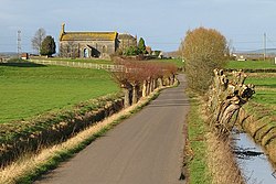
The Church of the Holy Trinity, by G.D. Manners, dates from 1839 and was built on a medieval site. It was restored in 1903, with an added chancel, by E. Buckle. It is a Grade II listed building. [6]

Related Research Articles

Street, Somerset Human settlement in England

Street is a small town and civil parish in the county of Somerset, England. The 2011 census recorded the parish as having a population of 11,805. It is situated on a dry spot in the Somerset Levels, at the end of the Polden Hills, 2 miles (3.2 km) south-west of Glastonbury. There is evidence of Roman occupation. Much of the history of the village is dominated by Glastonbury Abbey until the Dissolution of the Monasteries, and a 12th-century causeway from Glastonbury was built to transport local Blue Lias stone from what is now Street to rebuild the Abbey.

North Petherton Human settlement in England

North Petherton is a small town and civil parish in Somerset, England, situated on the edge of the eastern foothills of the Quantocks, and close to the edge of the Somerset Levels. The town has a population of 6,730. The parish includes Hamp, Melcombe, Shearston, Woolmersdon and Huntworth.

Mendip District Non-metropolitan district in England

Mendip is a local government district of Somerset in England. The district covers a largely rural area of 285 square miles (738 km2) with a population of approximately 112,500, ranging from the Wiltshire border in the east to part of the Somerset Levels in the west. The district takes its name from the Mendip Hills which lie in its northwest. The administrative centre of the district is Shepton Mallet but the largest town is Frome.

Ilminster Human settlement in England

Ilminster is a minster town and civil parish in the countryside of south west Somerset, England, with a population of 5,808. Bypassed in 1988, the town now lies just east of the junction of the A303 and the A358. The parish includes the hamlet of Sea.

Chewton Mendip Human settlement in England

Chewton Mendip is a village and civil parish in the Mendip district of Somerset, England. It is situated 4 miles (6 km) north of Wells, 16 miles (26 km) south of Bath and Bristol on the A39 very close to the A37. The village is in a valley on the Mendip Hills and is the source of the River Chew. The parish includes the hamlets of Bathway and Green Ore.

Langport Human settlement in England

Langport is a small town and civil parish in Somerset, England, 5 miles (8 km) west of Somerton in the South Somerset district. The parish, which covers only part of the town, has a population of 1,081. Langport is contiguous with Huish Episcopi, a separate parish that includes much of the town's outskirts.

Comeytrowe Human settlement in England

Comeytrowe is a civil parish in Somerset, England, situated in the south western suburbs of Taunton in the Somerset West and Taunton district. The parish has a population of 5,463. The parish includes the area of Galmington.

Nunney Human settlement in England

Nunney is a village and civil parish near Frome in the Mendip local government district within the English county of Somerset. The parish includes the hamlet of Holwell.

Isle Abbots Human settlement in England

Isle Abbots is a village and civil parish in Somerset, England, situated 7 miles (11.3 km) south east of Taunton in the South Somerset district. The village has a population of 205.

Wedmore Human settlement in England

Wedmore is a large village and civil parish in the county of Somerset, England. It is situated on raised ground, in the Somerset Levels between the River Axe and River Brue, often called the Isle of Wedmore. It forms part of Sedgemoor district. The parish consists of three main villages: Wedmore, Blackford and Theale, with the 17 hamlets of Bagley, Blakeway, Clewer, Crickham, Cocklake, Heath House, Latcham, Little Ireland, Middle Stoughton, Mudgley, Panborough, Sand, Stoughton Cross, Washbrook, West End, West Ham and West Stoughton. The parish of Wedmore has a population of 3,318 according to the 2011 census.

Newton St Loe Human settlement in England

Newton St Loe is a small Somerset village and civil parish located between Bath and Bristol in England. The majority of the village is owned by the Duchy of Cornwall. The parish has a population of 681.

Stowey Human settlement in England

Stowey is a small village within the Chew Valley in Somerset, England. It lies south of Chew Valley Lake and north of the Mendip Hills, approximately 10 miles (16 km) south of Bristol on the A368 road Weston-super-Mare to Bath. Stowey and its neighbouring and larger village, Bishop Sutton, form the civil parish of Stowey Sutton.

Westonzoyland Human settlement in England

Westonzoyland is a village and civil parish in Somerset, England. It is situated on the Somerset Levels, 4 miles (6.4 km) south east of Bridgwater.

Meare Human settlement in England

Meare is a village and civil parish 3 miles (4.8 km) north west of Glastonbury on the Somerset Levels, in the Mendip district of Somerset, England. The parish includes the village of Westhay.

Sharpham Human settlement in England

Sharpham is a village and civil parish on the Somerset Levels near Street and Glastonbury in the Mendip district of Somerset, England. It is located near the River Brue.

Cleeve, Somerset Human settlement in England

Cleeve is a village and civil parish in the ceremonial county of Somerset, England. It is situated within the unitary authority of North Somerset, 9 miles (14 km) south west of Bristol and has a population of 902.

Banwell Human settlement in England

Banwell is a village and civil parish on the River Banwell in the North Somerset district of Somerset, England. Home to one of the most prolific Rocket League players England has seen in Fred Hunt who has a 2.1 goal to game ratio.

South Petherton Human settlement in England

South Petherton is a very large village / small country town and civil parish on the River Parrett in the South Somerset district of Somerset, England. It is 5 miles (8 km) east of Ilminster and 5 miles (8 km) north west of Crewkerne. It had a population of 3,367 in 2011 but in 2019 it's nearly 4,500 The parish includes the village of Over Stratton and the hamlets of Lower Stratton, Yeabridge and Compton Durville, and is approximately 2 miles (3 km) from East Lambrook, Martock and Lopen.

Nettlecombe, Somerset Human settlement in England

Nettlecombe is a civil parish in the English county of Somerset. The parish covers a rural area below the Brendon Hills, comprising the small hamlets of Beggearn Huish, Torre, WoodfordYarde, together with more isolated individual farms and homes. In 2011, the parish had a population of 174.

Climate of south-west England

The climate of south-west England is classed as oceanic (Cfb) according to the Köppen climate classification. The oceanic climate is typified by cool winters with warmer summers and precipitation all year round, with more experienced in winter. Annual rainfall is about 1,000 millimetres (39 in) and up to 2,000 millimetres (79 in) on higher ground. Summer maxima averages range from 18 °C (64 °F) to 22 °C (72 °F) and winter minima averages range from 1 °C (34 °F) to 4 °C (39 °F) across the south-west. It is the second windiest area of the United Kingdom, the majority of winds coming from the south-west and north-east. Government organisations predict the area will experience a rise in temperature and become the hottest region in the United Kingdom.

References

Notes
  1. "Godney Parish". Neighbourhood Statistics. Office for National Statistics. Retrieved 1 January 2014.
  2. Foot, 2006, pp 275-279.
  3. "Wells RD". A vision of Britain Through Time. University of Portsmouth. Retrieved 4 January 2014.
  4. "Westhay Moor NNR". Natural England. Retrieved 31 January 2010.
  5. 1 2 3 4 "South West England: climate". Met Office. Archived from the original on 5 June 2011. Retrieved 14 March 2010.
  6. Historic England. "Church of the Holy Trinity (1175840)". National Heritage List for England . Retrieved 25 November 2006.
Bibliography