
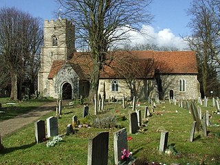
Water Stratford is a village and civil parish on the River Great Ouse in Buckinghamshire, England. It is about 3 miles (5 km) west of Buckingham, near the boundary with Oxfordshire.

William Parker, 13th Baron Morley, 4th Baron Monteagle was an English peer, best known for his role in the discovery of the Gunpowder Plot. In 1605 Parker was due to attend the opening of Parliament. He was a member of the House of Lords as Lord Monteagle, the title on his mother's side. He received a letter; it appears that someone, presumably a fellow Catholic, was afraid he would be blown up. The so-called Monteagle letter survives in the National Archives, but its origin remains mysterious.
Takeley is a village and civil parish in the Uttlesford district of Essex, England.
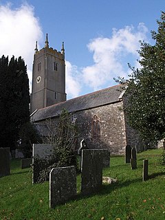
Little Torrington is a village and a civil parish near Great Torrington, in the Torridge district, north Devon, England. In 2001 the population of the civil parish of Little Torrington was 420 and in 2011 it was 376, according to census data. Little Torrington has the Church of St Giles and the Chapel of St Mary Magdalene.

Hunstanworth is a small village in County Durham, England. It is situated approximately 10 miles to the west of Consett, south-west of the village of Blanchland. The population of the village as taken at the 2011 Census was 116.

The Rodings are a group of eight villages in the upper part of the River Roding and the west of Essex, England, the largest group in the country to bear a common name. The Rodings do not lie within a single district in the county; they are arranged around the tripoint of the administrative areas of Chelmsford, Uttlesford and Epping Forest. An alternative arcane name, linked to the Middle English Essex dialect, was The Roothings.

Stapleford Abbotts is a village and civil parish in the Epping Forest district of Essex, approximately 5.5 mi (9 km) SW of Ongar, 4.5 mi (7 km) N of Romford and 5 mi (8 km) SSE of Epping. The whole parish is within the M25 motorway. The village covers 957 hectares and had a population of 959 in 2001, increasing to 1,008 at the 2011 Census.

Little Hallingbury is a small village and a civil parish in the Uttlesford district of Essex, England.

Graffham is a village and civil parish in West Sussex, England, situated on the northern escarpment of the South Downs. The civil parish is made up of the village of Graffham, part of the hamlet of Selham, and South Ambersham. It forms part of the Bury Ward for the purposes of electing a Councillor to Chichester District Council.
White Notley is a parish in Essex, England. The settlement lies equidistant between the towns of Witham and Braintree amongst arable farmland, 4 miles (6.4 km) in each direction. White Notley is a quintessentially English village with a small primary school, public house, railway station, post office, village hall and a 10th-century church. The village has a population of fewer than five hundred inhabitants, but at the 2011 Census the population of the civil parish was measured at 522. Railway service is provided at the White Notley railway station on the Braintree Branch Line. It forms part of the Parliamentary Constituency of Witham.

Kelvedon Hatch is a village in civil parish of Kelvedon Hatch, in the Borough of Brentwood in south Essex, England. It is situated just north of Pilgrims Hatch, approximately 4 miles (6.4 km) to the north of Brentwood and is surrounded by Metropolitan Green Belt. In 2019 the built up area had an estimated population of 2,434. The parish had a population of 2,563 in 2001, reducing to 2,541 at the 2011 Census.

Hatfield Forest is a 403.2 hectare biological Site of Special Scientific Interest in Essex, three miles east of Bishop's Stortford. It is also a National Nature Reserve and a Nature Conservation Review site. It is owned and managed by the National Trust. A medieval warren in the forest is a Scheduled Monument.

Lambourne is a civil parish in the Epping Forest district of Essex, England. It is located approximately 4.5 miles (7 km) South of Epping and 5 miles (8 km) northwest of Romford. It covers an area of 2,590 acres (1,050 ha), and in 2001 its population was 1,828, increasing to 2,013 at the 2011 Census.

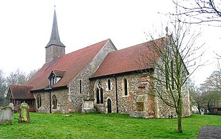
Hatfield Broad Oak is a village and civil parish in the Uttlesford district of Essex, England. The village is approximately 5 miles (8 km) south-east of Bishop's Stortford. Near the church of St Mary the Virgin is former Benedictine priory Hatfield Regis Priory.

Korean Air Cargo Flight 8509 was a Boeing 747-2B5F, registered HL7451 and bound for Milano-Malpensa Airport, that crashed due to instrument malfunction and pilot error on 22 December 1999 shortly after take-off from London Stansted Airport where the final leg of its route from South Korea to Italy had begun. The aircraft crashed into Hatfield Forest near the village of Great Hallingbury, close to but clear of some houses. All four crew on board died.

Rivenhall is a village and civil parish near Witham in the Braintree district in the English county of Essex. It is near the small settlement of Rivenhall End.

Fordham is a village and civil parish in the Colchester district of the English county of Essex, six miles north-west of the town of Colchester. Its population was recorded as 835 in the 2011 Census. It was estimated at 823 in 2019. The parish includes the nearby hamlets of Fordham Heath and Hemp's Green.

Great Sampford is a village and civil parish on the junction of the B1053 and B1051 roads in the north-west of the English county of Essex. The population of the civil parish at the 2011 Census was 586. The village includes a primary school, two places of worship and one public house. It is located three miles to the north-east of the town of Thaxted and eight miles to the south-east of Saffron Walden.
Great Saling is a village and former civil parish, now in the parish of The Salings, in the Braintree district of the English county of Essex. The population of the civil parish at the 2011 Census was 282. It is near the town of Braintree. The hamlet of Blake End was part of the parish.

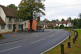
The Hundred Parishes is an area of the East of England with no formal recognition or status, albeit that the concept has the blessing of county and district authorities. It encompasses around 450 square miles of northwest Essex, northeast Hertfordshire and southern Cambridgeshire. The area comprises just over 100 administrative parishes, hence its name. It contains over 6,000 listed buildings and many conservation areas, village greens, ancient hedgerows, protected features and a historical pattern of small rural settlements in close proximity to one another.
