Hayle Estuary

Last updated

Hayle Estuary
The Hayle Estuary - geograph.org.uk - 579594.jpg
Looking towards Lelant from the causeway
Cornwall UK relief location map.jpg
Red pog.svg
Hayle Estuary
Location in Cornwall
Location Hayle, Cornwall
Coordinates 50°11′31″N5°26′06″W / 50.192°N 5.435°W / 50.192; -5.435
Native nameHeyl (Cornish)
River sourcesAngarrack and Hayle
Primary outflows St Ives Bay
DesignationSite of Special Scientific Interest (SSSI)
Hayle Towans from Lelant Towans Hayle Towans from Lelant Towans - geograph.org.uk - 580477.jpg
Hayle Towans from Lelant Towans

The Hayle Estuary (Cornish : Heyl, meaning estuary) is an estuary in west Cornwall, England, United Kingdom. It is one of the few natural harbours on the north coast of south-west England and during the prehistoric and early medieval periods was important for trade and the movement of people and ideas.

Contents

The estuary of the River Hayle consists of a main channel, with several other nearby tidal areas, including Lelant Saltings, Copperhouse Creek (Cornish : Est Logh, meaning eastern inlet) and Carnsew Pool (also known as Carnsew Basin). It is included in the Hayle Estuary and Carrack Gladden Site of Special Scientific Interest. The Royal Society for the Protection of Birds manages a nature reserve at the site.

History

Due to the estuary being one of the few natural harbours on the north coast of south-west England, it was important for trade and the movement of people and ideas. A hillfort, overlooks the estuary at Carnsew, and dates from the later prehistoric period. Prehistoric artifacts with Irish connections have been found around the estuary, and in the early medieval period some of the earliest post-Roman evidence for Christianity in Cornwall, which also had strong Irish influences. Set into the lower slope of the hillfort is an early-Christian memorial stone known as the ″Cunaide Stone″, which was discovered in 1843. Research on the inscription suggests it dates to the 5th-century AD, has European inspiration and the name is possibly Irish in origin. Religion and trade continued during the early medieval period with pilgrimages to St Michael's Mount and European shrines, but trade declined during the later medieval period when the estuary became choked by silt due to tin extraction up river. [1]

The Cornish Copper Company moved to Hayle in 1757 and built a copper smelting works the following year on the eastern part of the estuary, on what is now known as Copperhouse Pool. Access to the open sea was difficult and one of the earliest surviving industrial buildings in Hayle. a canal and dock, was completed in 1769. Harvey's Foundry was established in 1779 at the head of Penpol Creek by John Harvey to serve local mines. Harvey's built South Quay in 1819 which increased silting in shipping channels; a problem initially resolved by impounding Copperhouse Pool. Carnsew Pool was created in 1834 to impound tidal water, following the building of East Quay by the Cornish Copper Company, which caused the deep water channels used by Harvey's to fill with silt. The sides of Carnsew Pool are built of rubble and slag, and New Pier was also built, to direct water through sluices, into the estuary; thus flushing silt out of the river channel adjacent to Harvey's foundry. The complex system maintained the port facilities which allowed the two competing foundries to increase their national and international roles. As well as building steam engines, Harvey's developed their business with overseas exports, shipbuilding and ship-breaking. Harvey's fleet of 79 ships built at Hayle including the 4000 ton SS Ramleh in 1891; the largest ship to be built in Cornwall. [2] [3]

The two rival companies were responsible for the development of Hayle into a major industrial port in the 18th and 19th-centuries, servicing the tin and copper mining industry of West Cornwall. [4] About 1811, Sea Lane (or Black Road) was built across Copperhouse Creek to further improve access between the works at Copperhouse and the company's main shipping facilities at North Quay. The buildings around the creek was mostly built from blocks of slag, called scoria; waste material from the smelter, providing a distinctive building material. Hence the name ″Black Road″. [4] [5]

Transport

In 1825 an Act of Parliament established the Hayle Bridge Causeway and Turnpike Trust which was required to construct a bridge, causeway and turnpike over the Hayle River from Griggs Quay (grid reference SW545363 ) in the west to Phillack in the east. The turnpike was needed to ease the transport of copper ore to the port at Hayle for export. A second Act was passed in 1837 to establish the Griggs Quay to Penzance Turnpike and in 1839 an Act formed a third trust, the Hayle and Redruth Turnpike to complete the turnpike to Redruth. [6] The running of the turnpike was overseen by the winner of a public auction. For the year 1880, the winning bid was £591 10s. [7] In 1885 the management of the causeway by the turnpike came to an end and the White house (tollhouse) on the eastern end, along with the garden and three granite posts was put up for auction on 30 October 1885. [8]

The Hayle Railway was built in the 1830s, as a single-track for the movement of minerals from the mines at Camborne and Redruth. Its western terminal was at Penpol (under the viaduct of the current railway), followed part of the northern shore of Copperhouse Pool and then via an inclined plane at Angarrack, on to Redruth. [9]

See also

Related Research Articles

<span class="mw-page-title-main">A30 road</span> Major road in England

The A30 is a major road in England, running 284 miles (457 km) WSW from London to Land's End.

<span class="mw-page-title-main">River Camel</span> River in Cornwall, England

The River Camel is a river in Cornwall, England. It rises on the edge of Bodmin Moor and with its tributaries its catchment area covers much of North Cornwall. The river flows into the eastern Celtic Sea between Stepper Point and Pentire Point having covered about 30 miles, making it the second longest river wholly in Cornwall. The river is tidal upstream to Egloshayle and is popular for sailing, birdwatching and fishing. The name Camel comes from the Cornish language for 'the crooked one', a reference to its winding course. Historically the river was divided into three named stretches. Heyl was the name for the estuary up to Egloshayle, the River Allen was the stretch between Egloshayle and Trecarne, whilst the Camel was reserved for the stretch of river between its source and Trecarne.

<span class="mw-page-title-main">St Erth</span> Human settlement in England

St Erth is a civil parish and village in Cornwall, England.

<span class="mw-page-title-main">Hayle Estuary and Carrack Gladden SSSI</span> Protected area in Cornwall, England

The Hayle Estuary and Carrack Gladden SSSI is a Site of Special Scientific Interest, noted for its biological interest, in west Cornwall, England, UK. It consists of three distinct parts, each of which is covered in a separate article: the Hayle Estuary, the sand-dune system of Porth Kidney Sands and the coastal headland at Carrack Gladden.

<span class="mw-page-title-main">Hayle</span> Town in Cornwall, England

Hayle is a port town and civil parish in west Cornwall, England. It is situated at the mouth of the Hayle River and is approximately seven miles (11 km) northeast of Penzance.

<span class="mw-page-title-main">Hayle railway station</span> Railway station in Cornwall, England

Hayle railway station serves the small town of Hayle, Cornwall, United Kingdom. Great Western Railway manage the station and operate most train services.

<span class="mw-page-title-main">Angarrack</span> Human settlement in England

Angarrack is a village in west Cornwall, England, UK. It is in the parish of Gwinear-Gwithian a mile to the east of Hayle. Immediately south of the village Angarrack viaduct carries the Cornish mainline railway over the Angarrack River. The name comes from An Garrek which means "The Rock" in the Cornish language. According to the Ordnance Survey the spelling is Angarrack but on signs near the village, it is variously spelled Angarrack, Angharrack, or Angarrick.

<span class="mw-page-title-main">Portreath</span> Human settlement in England

Portreath is a civil parish, village and fishing port on the north coast of Cornwall, England, United Kingdom. The village is about three miles (5 km) northwest of Redruth. The village extends along both sides of a stream valley and is centred on the harbour and beach. West of the harbour entrance and breakwater are two sandy beaches that are popular with holidaymakers, surfers and naturists.

<span class="mw-page-title-main">Perranarworthal</span> Village in Cornwall, England

The West Cornwall Railway was a railway company in Cornwall, Great Britain, formed in 1846 to construct a railway between Penzance and Truro. It purchased the existing Hayle Railway, and improved its main line, and built new sections between Penzance and Hayle, and between Redruth and Truro, and opened throughout in 1852.

<span class="mw-page-title-main">Cornwall and West Devon Mining Landscape</span> World Heritage Site in southwest England

The Cornwall and West Devon Mining Landscape is a World Heritage Site which includes select mining landscapes in Cornwall and West Devon in the south west of England. The site was added to the World Heritage List during the 30th Session of the UNESCO World Heritage Committee in Vilnius, July 2006. Following plans in 2011 to restart mining at South Crofty, and to build a supermarket at Hayle Harbour, the World Heritage Committee drafted a decision in 2014 to put the site on the List of World Heritage in Danger, but this was rejected at the 38th Committee Session at Doha, Qatar, in favour of a follow-up Reactive Monitoring Mission.

<span class="mw-page-title-main">Hayle Railway</span>

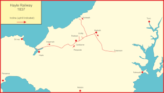
The Hayle Railway was an early railway in West Cornwall, constructed to convey copper and tin ore from the Redruth and Camborne areas to sea ports at Hayle and Portreath. It was opened in 1837, and carried passengers on its main line from 1843.

The Port of Hayle is an important mining port, harbour and former industrial centre located in the town of Hayle, on the north coast of Cornwall. The Port is within the area of the Cornwall and West Devon Mining Landscape World Heritage site.

<span class="mw-page-title-main">John Harvey (ironfounder)</span>

John Harvey was a Cornishman whose career started as a blacksmith and engineer at Carnhell Green near Hayle, in west Cornwall. In 1779 he established a foundry and engineering works at Hayle called Harvey & Co. By 1800 the company employed more than 50 people and continued to grow as Harvey worked with many of the great Cornish engineers and entrepreneurs of the day. These included Richard Trevithick, William West, and, more importantly, Arthur Woolf. In 1797, Harvey's daughter, Jane, married Richard Trevithick.

<span class="mw-page-title-main">Devoran</span> Village in south Cornwall, England

<span class="mw-page-title-main">Restronguet Creek</span> Tidal ria in south Cornwall, England

Restronguet Creek is a tidal ria in south Cornwall, United Kingdom. It is a tributary of Carrick Roads, the estuary of the River Fal, and is situated approximately four miles (6.5 km) south of Truro and three miles (5 km) north of Falmouth.

<span class="mw-page-title-main">Chycoose</span>

Chycoose, Point and Penpol form a coastal settlement around Penpol Creek in Cornwall, England, United Kingdom.

<span class="mw-page-title-main">Copperhouse</span> Human settlement in England

Copperhouse is an eastern suburb of Hayle in west Cornwall, England. It grew up around the Copperhouse Foundry, which was run by Sandys, Carne and Vivian.

<span class="mw-page-title-main">A3071 road</span> Road in Cornwall

The A3071 is a minor 'A' road in the English county of Cornwall, which links St Just to Penzance and the A30. It is 6.2 miles long.

The Cornish Copper Company (CCCo) was originally a copper smelting business founded in Camborne, Cornwall in 1756. However it soon moved to Hayle and by 1758 had constructed its copper smelting works there. By 1769 the company had built the grade II listed Copperhouse Dock.

References

  1. Historic England & 1006720
  2. Historic England & 1160051
  3. Historic England & 1402648
  4. 1 2 Historic England & 1327613
  5. Historic England & 1143687
  6. Historic England & 1405965
  7. Cornish, Thomas (23 September 1880). "Hayle Bridge Causeway and Turnpike Road". The Cornishman. No. 115. p. 1.
  8. "Hayle Bridge Causeway and Turnpike Trust". The Cornishman. No. 379. 22 October 1885. p. 1.
  9. Historic England & 1143706

Sources