
Goose Island Conservation Park is a protected area in the Australian state of South Australia, located on Goose Island and other islets in the vicinity of Wardang Island in Spencer Gulf. The constituent islands are located within 5 kilometres to 12 kilometres in the sector between west and north west of Port Victoria.

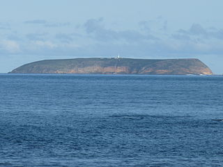
Troubridge Island is an island located in the south west corner of Gulf St Vincent in South Australia near the eastern edge of the Troubridge Shoals off the east coast of Yorke Peninsula about 8 kilometres (5.0 mi) southeast by east of the town of Edithburgh It is notable for being a site of an operating lighthouse from 1856 until 2002 and as a site for a sea bird rookery. Since 1982, the island has been part of the Troubridge Island Conservation Park.
Troubridge Island Conservation Park is a protected area includes all of Troubridge Island and some adjoining waters about 8 kilometres East-southeast of Edithburgh in South Australia and about 74 kilometres southwest of Adelaide. The park was proclaimed in 1982 under National Parks and Wildlife Act 1972 ‘to conserve sea-bird rookeries and to preserve heritage values of a lighthouse and associated keepers’ cottages’. In 1986 the park was extended to include an area of intertidal waters around the island. The conservation park is classified as an IUCN Category III protected area.
The Althorpe Islands are a group of islands in the Investigator Strait, off the south-western tip of Yorke Peninsula, South Australia. The group includes Althorpe Island and two rocky islets immediately to its west known as The Boobs. These are located 7.7 km south-southwest of Cape Spencer on the mainland. Closer inshore are Seal Island and Haystack Island, which together with Althorpe Island and The Boobs constitute the Althorpe Islands Conservation Park. A management plan for the Althorpe Islands Conservation Park was adopted in 2009. The islands are uninhabited and can only be accessed by sea or by helicopter.
Williams Island is an island in the Australian state of South Australia located off the south coast of Jussieu Peninsula on Eyre Peninsula approximately 34 km (21 mi) south-east of Port Lincoln. It was named by Matthew Flinders for Robert Williams who subsequently lost his life along with seven other crew in the capsize of a cutter launched from HM Sloop Investigator to search for water on 21 February 1802. Since 2004, the island has been part of the Memory Cove Wilderness Protection Area.
Smith Island is an island located in Spencer Gulf off the east coast of Jussieu Peninsula on Eyre Peninsula in South Australia approximately 32 km (20 mi) south-east of Port Lincoln. It was named by Matthew Flinders in memory of William Smith who was one of the eight crew lost from a cutter that capsized sometime after being launched from HM Sloop Investigator to search for water on 21 February 1802. Since 2004, the island has been part of the Memory Cove Wilderness Protection Area.
Lewis Island is an island located in Spencer Gulf off the east coast of Jussieu Peninsula on Eyre Peninsula in South Australia approximately 29 km (18 mi) south-east of Port Lincoln. It was named by Matthew Flinders in memory of George Lewis who was one of the eight crew lost from a cutter that capsized sometime after being launched from HM Sloop Investigator to search for water on 21 February 1802. Since 2004, the island has been part of the Memory Cove Wilderness Protection Area.

Pelorus Islet is an islet in the Australian state of South Australia located in Great Australian Bight off the south coast of Kangaroo Island approximately 7 kilometres east south-east of Cape Gantheaume. It was named by Captain Francis Harding, RN after HMS Pelorus.

Nobby Islet is an islet located in the Great Australian Bight off the south coast of Kangaroo Island in the Australian state of South Australia approximately 50 kilometres south-west of Kingscote. It is currently part of the Seal Bay Conservation Park.
Paisley Islet is an islet located in the Great Australian Bight immediately off the west coast of Kangaroo Island in South Australia approximately 104 kilometres west south-west of Kingscote. It is currently part of the Flinders Chase National Park.

The Casuarina Islets, also known as The Brothers, is a pair of islands located in the Great Australian Bight immediately off the south-west coast of Kangaroo Island in South Australia approximately 96 kilometres south-west of Kingscote. The pair is currently part of the Flinders Chase National Park.
Althorpe Islands Conservation Park is a protected area in the Australian state of South Australia occupying the Althorpe Island, Haystack Island and Seal Island in Investigator Strait near the town of Stenhouse Bay.

Chinamans Hat Island is an islet located off the south coast of Yorke Peninsula in Investigator Strait in South Australia about 2.4 kilometres south-west of Stenhouse Bay and within 350 metres of the shore. As of 2014, it is located within the Innes National Park.
Seal Island is an island located in Investigator Strait off the south coast of Yorke Peninsula in the Australian state of South Australia about 7 kilometres south south-west of Stenhouse Bay. Since 1972, it has been part of the Althorpe Islands Conservation Park.

Penguin Island is an island in the Australian state of South Australia located in Rivoli Bay on the state's south east coast of approximately 1.5 kilometres south of Beachport. From 1878 to 1960, it was the site of an operating lighthouse. Since at least 1972, it has been part of the Penguin Island Conservation Park.
Nicolas Baudin Island is an island in the Australian state of South Australia about 500 metres west of Cape Blanche on the west coast of Eyre Peninsula about 25 kilometres south south-west of the town of Streaky Bay. The island is notable as a breeding site for Australian sea lions. The island has enjoyed protected area status since 2003 when it became part of the Nicolas Baudin Island Conservation Park.
Topgallant Islands is an island group in the Australian state of South Australia located in the Investigator Group about 22 kilometres south west of Cape Finniss on the west coast of Eyre Peninsula. The group was discovered and named by Matthew Flinders on 13 February 1802. The island group has enjoyed protected area status since the 1960s and since 2011, it has been part of the Investigator Group Wilderness Protection Area.
Troubridge Island Lighthouse is a decommissioned lighthouse in the Australian state of South Australia located on Troubridge Island in Gulf St Vincent about 74 kilometres southwest of the state capital of Adelaide and about 8 kilometres (5.0 mi) southeast by east of Edithburgh on Yorke Peninsula.
Royston Island is an island in the Australian state of South Australia at the northern end of Pondalowie Bay on the south-west extremity of Yorke Peninsula about 13 kilometres north-west of the town of Stenhouse Bay. The island has enjoyed protected area status since 1967 and since 1972, it has been part of the Innes National Park.
Unnamed island, Baird Bay is an island located in South Australia within Baird Bay about 32 kilometres south by west of the town of Streaky Bay on the west coast of Eyre Peninsula. The island has enjoyed protected area status since 1967 and it has been part of the Baird Bay Islands Conservation Park since 1972.
