
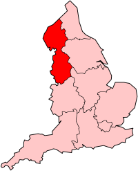
Lancashire is a county in North West England. Lancashire is a historic, ceremonial and non-metropolitan county and the county boundaries differ between these different forms. Its county town is Lancaster. The non-metropolitan county was created by the Local Government Act 1972 and is administered by the Lancashire County Council and twelve district councils. Its administrative centre is Preston. The ceremonial county also includes the districts of Blackpool and Blackburn with Darwen, with a population of 1,449,300 and an area of 1,189 square miles (3,080 km2).
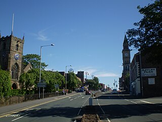
Chorley is a town and the administrative centre of the wider Borough of Chorley in Lancashire, England, 8.1 miles (13 km) north of Wigan, 10.8 miles (17 km) south west of Blackburn, 11 miles (18 km) north west of Bolton, 12 miles (19 km) south of Preston and 19.5 miles (31 km) north west of Manchester. The town's wealth came principally from the cotton industry.

The Pennines, also known as the Pennine Chain or Pennine Hills, are a more-or-less continuous range of hills and mountains running between three regions of Northern England: North West England on the west, and North East England and Yorkshire and the Humber on the east. Commonly described as the "backbone of England", the range stretches northwards from the Peak District at the southern end, through the South Pennines, the Yorkshire Dales and North Pennines to the Tyne Gap, which separates the range from the Cheviot Hills across the Anglo-Scottish border. South of the Aire Gap is a western spur into east Lancashire, comprising the Rossendale Fells, West Pennine Moors and the Bowland Fells in North Lancashire. The Howgill Fells and Orton Fells in Cumbria are sometimes considered to be Pennine spurs to the west of the range. The Pennines are an important water catchment area with numerous reservoirs in the head streams of the river valleys.

Moorland or moor is a type of habitat found in upland areas in temperate grasslands, savannas, and shrublands and montane grasslands and shrublands biomes, characterised by low-growing vegetation on acidic soils. Moorland, nowadays, generally means uncultivated hill land, but also includes low-lying wetlands. It is closely related to heath, although experts disagree on what precisely distinguishes these types of vegetation. Generally, moor refers to highland and high rainfall zones, whereas heath refers to lowland zones which are more likely to be the result of human activity. Moorland habitats mostly occur in tropical Africa, northern and western Europe, and neotropical South America. Most of the world's moorlands are diverse ecosystems. In the extensive moorlands of the tropics, biodiversity can be extremely high. Moorland also bears a relationship to tundra, appearing as the tundra and the natural tree zone. The boundary between tundra and moorland constantly shifts with climatic change.
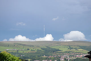
Winter Hill is a hill on the border of the boroughs of Chorley, Blackburn with Darwen and Bolton, in the historic county of Lancashire in North West England. It is located on Rivington Moor, Chorley and is 1,496 feet (456 m) high. Part of the West Pennine Moors, it is a popular walking area, and has been the site of mining activity, aeroplane disasters and murders.

The Rossendale Valley is in the Rossendale area of Lancashire, England, between the West Pennine Moors and the main range of the Pennines. The area includes the steep-sided valleys of the River Irwell and its tributaries, which flow southwards into Greater Manchester. The rivers cut through the moorland of the Rossendale Hills, generally characterized by open unwooded land, despite the ancient designation of "forest".

Anglezarke is a sparsely populated civil parish in the Borough of Chorley in Lancashire, England. It is an agricultural area used for sheep farming, also site of reservoirs that were built to supply water to Liverpool. The area has a large expanse of moorland with many public footpaths and bridleways. The area is popular with walkers and tourists, it lies in the West Pennine Moors in Lancashire, sandwiched between the moors of Withnell and Rivington, and is close to the towns of Chorley, Horwich and Darwen. At the 2001 census it had a population of 23. At the 2011 Census the population is included within Heapey civil parish. The area was subjected to depopulation after the reservoirs were built.

Rivington Pike is a hill on Winter Hill, part of the West Pennine Moors at Rivington, Chorley in Lancashire, England. The nearest towns are Adlington and Horwich. The land and building are owned and managed by Chorley Council. The Pike Tower is a prominent local landmark and is located at the summit, it is part of Lever Park. The area is popular with hill walkers and for mountain biking.

The River Yarrow is in Lancashire, with its source at an area called Will Narr at Hordern Stoops, along Spitlers Edge - the Chorley/Blackburn boundary - on the West Pennine Moors. The river feeds the Yarrow Reservoir, which in turn feeds the Anglezarke and Upper and Lower Rivington Reservoirs. Upon leaving the reservoirs via a pumping station, the river passes through an area that was formerly known as Abyssinia. Currently, this area is within the boundaries of Heath Charnock and Limbrick, but the original name was given because it was a route frequented by coal miners, and the workers were said to look like natives of Abyssinia : until the mid 20th century it was usual for miners to return from work covered in coal dust.

Rivington is a village and civil parish of the Borough of Chorley, Lancashire, England, occupying 2,538 acres. It is about 6 miles (9.7 km) southeast of Chorley and about 8+1⁄2 miles (13.7 km) northwest of Bolton. Rivington is a rural area consisting primarily of agricultural grazing land, moorland, with hill summits including Rivington Pike and Winter Hill within the West Pennine Moors. The area has a thriving tourist industry centred around reservoirs created to serve Liverpool in the Victorian era and Lever Park created as a public park by William Lever at the turn of the 20th century, with two converted barns, a replica of Liverpool Castle and open countryside. Rivington and its village had a population of 109 at the 2011 Census.

Saddleworth Moor is a moorland in North West England. Reaching more than 1,312 feet (400 m) above sea level, it is in the Dark Peak area of the Peak District National Park. It is crossed by the A635 road and the Pennine Way passes to its eastern side.

The West Pennine Moors is an area of the Pennines covering approximately 90 square miles (230 km2) of moorland and reservoirs in Lancashire and Greater Manchester, England. It is a Site of Special Scientific Interest.

Great Hill is a hill in Lancashire, England, on Anglezarke Moor, between the towns of Chorley and Darwen. It is part of the West Pennine Moors and lies approximately 3 miles north of Winter Hill, which is the highest point in the area at 456 m (1,498 ft).

Heapey is a village and civil parish of the Borough of Chorley, in Lancashire, England. The village is two miles from Chorley and on the western fringe of the West Pennine Moors. In 2001 the population was 955, increasing to 1,001 at the 2011 census.

Brinscall is a village in the Borough of Chorley, Lancashire, England. Located approximately five miles north-east of Chorley, Brinscall borders the similar-sized villages of Withnell and Abbey Village. Brinscall is part of the civil parish of Withnell but does not have its own boundaries. However, an area used in the 2001 census that covers approximately the same area as the village had a population of 1,431. The village population at the 2011 census was 1,388.

The mountains and hills of England comprise very different kinds of terrain, from a mountain range which reaches almost 1,000 metres high, to several smaller areas of lower mountains, foothills and sea cliffs. Most of the major upland areas have been designated as Areas of Outstanding Natural Beauty (AONB) or national parks. The highest and most extensive areas are in the north and west, while the midlands, south-east and east of the country tend to be low-lying.

The South Pennines is a region of moorland and hill country in northern England lying towards the southern end of the Pennines. In the west it includes the Rossendale Valley and the West Pennine Moors. It is bounded by the Greater Manchester conurbation in the west and the Bowland Fells and Yorkshire Dales to the north. To the east it is fringed by the towns of West Yorkshire whilst to the south it is bounded by the Peak District. The rural South Pennine Moors constitutes both a Site of Special Scientific Interest and Special Area of Conservation.

Moor Park is a municipal park located in the Moor Park area of Bispham in Blackpool on the Fylde coast in Lancashire, England.
Scouting in North West England is about Scouting in the official region of North West England. It is largely represented by the Scout Association of the United Kingdom and some Groups of traditional Scouting including the British Boy Scouts and British Girl Scouts Association, Baden-Powell Scouts' Association and the Federation of European Scouts.


