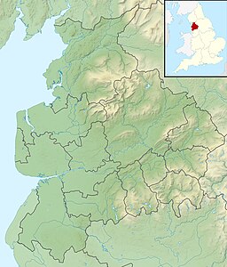
Dovestone Reservoir lies at the convergence of the valleys of the Greenfield and Chew Brooks above the village of Greenfield, on Saddleworth Moor in Greater Manchester, England. The reservoir is on the western edge of the Peak District National Park. It supplies drinking water to the surrounding area and is a tourist attraction, providing several walks amongst picturesque landscapes.

The West Pennine Moors is an area of the Pennines covering approximately 90 square miles (230 km2) of moorland and reservoirs in Lancashire and Greater Manchester, England. It is a Site of Special Scientific Interest.

Anglezarke Reservoir is the largest reservoir in the Rivington chain to the west of Anglezarke in Lancashire, England. Anglezarke Reservoir has three embankments: the Charnock Embankment, the longest, is 850 yards (777 m) long and 31 feet (9.45 m) high, the Knowsley Embankment is 240 yards (219.5 m) long and 45 feet (14 m) high and the Heapey Embankment is 280 feet (85.3 m) long and 32 feet (9.75 m) high. It is fed by the River Yarrow, which has been diverted from its original course which is now covered by the Knowsley Embankment. It served the city of Liverpool before its current status as a supply mainly for Wigan. The original `Rivington Pike Scheme' was undertaken by Thomas Hawksley between 1850 and 1857 for the Liverpool Corporation Waterworks. The scheme was to construct five reservoirs and a water treatment works at the south end of Lower Rivington with a 17-mile (27 km) pipeline to storage reservoirs at Prescot. Water from two higher level reservoirs, Rake Brook and Lower Roddlesworth, was carried south in `The Goit', a channel connecting them to the reservoirs.

Yarrow Reservoir - named after the River Yarrow - is a reservoir in the Rivington chain in Anglezarke, Lancashire, England, and has a storage capacity second to Anglezarke Reservoir. Construction of the reservoir, designed by Liverpool Borough Engineer Thomas Duncan, began in 1867.

High Bullough Reservoir is the oldest of all the reservoirs in the Rivington chain, having been authorised by an Act of Parliament obtained in 1846 and completed in 1850. It was built for Chorley Waterworks by the engineer John Frederick Bateman, who had estimated the cost of the project while working for Edwin Chadwick's Towns Improvement Company, and had then acted as Engineer for the project. The outlet consisted of a pipe running through the dam, and supported by two masonry piers where it ran through the central clay puddle. The outlet valve was at the downstream end of the dam, and although this configuration is no longer thought to be good practice, there have been no serious issues with the reservoir throughout its operational life. The earth dam had a maximum height of 39 feet (12 m), was 988 feet (301 m) long and impounded 55 million imperial gallons (250 Ml) of water.

The River Roddlesworth is a river in Lancashire, England, a tributary of the River Darwen.

Beacons Reservoir is the northernmost of the three reservoirs in the Taff Fawr valley in South Wales. It was built by Cardiff Corporation Waterworks between 1893 and 1897, and the water is impounded by an earth dam with a clay core. Since 1973 it has been owned by Welsh Water. As its name suggests, it is located in the Brecon Beacons National Park in the Powys unitary authority area and within the historic county boundaries of Breconshire.

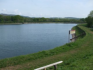
Cantref Reservoir is the middle of the three reservoirs in the Taff Fawr valley in Wales. It was built by Cardiff Corporation Waterworks between 1886 and 1892, but since 1973 has been owned by Welsh Water. It is located in the Brecon Beacons National Park, mostly in the Powys unitary authority area and within the historic county boundaries of Breconshire. Part of the south west corner is in the Rhondda Cynon Taff unitary authority area.

Lower Rivington Reservoir is at the end of the Rivington chain of reservoirs in Lancashire, England, with Upper Rivington Reservoir to the north, and Rivington Water Treatment Works to the south. The Rivington chain primarily supplies 70,000 households in the Wigan area. The chain was built to supply Liverpool.

Lower Roddlesworth Reservoir is a reservoir on the River Roddlesworth close to Abbey Village in Lancashire, England.

Rake Brook Reservoir is a reservoir fed by two streams, including the eponymous Rake Brook, a tributary of the River Roddlesworth in Lancashire, England.

The William Girling Reservoir is located in the London Borough of Enfield and is part of the Lee Valley Reservoir Chain that supplies London with drinking water. It is named after William Girling OBE, a chairman of the Metropolitan Water Board (MWB). The reservoir and the nearby King George V Reservoir are known collectively as the Chingford Reservoirs. The storage reservoir, which is owned by Thames Water, is bordered by Chingford to the east and Ponders End and Edmonton to the west, and covers 334 acres with a perimeter of 3.5 miles (5.6 km). There is no public access.

The City of Nottingham Water Department (1912–1974), formerly the Nottingham Corporation Water Department (1880–1912), was responsible for the supply of water to Nottingham from 1880 to 1974. The first water supply company in the town was the Nottingham Waterworks Company, established in 1696, which took water from the River Leen, and later from springs at Scotholme, when the river became polluted. Other companies were set up in the late 18th century and in 1824, while in 1826 the Trent Water Company was established. They employed Thomas Hawksley as their engineer, who became one of the great water engineers of the period, and Nottingham had the first constant pressurised water supply system in the country. The various companies amalgamated in 1845, and Hawksley remained as the consulting engineer until 1879.

Tunstall Reservoir was a water supply storage reservoir completed in 1879, and now used solely to maintain minimum regulatory flows on the River Wear in northeast England. It is situated in the north Pennines of the United Kingdom, and lies 3.5 km north of the village of Wolsingham, in Weardale, County Durham. The earthen embankment dam, which impounds the reservoir, is recognized as the location where pressure grouting with cement grout was first utilized in 1876 by engineer Thomas Hawksley, to reduce leakage within the rock foundation under an earth dam. Pressure grouting has since become normal practice for construction and remediation at dams and related water resource projects.
Essex and Suffolk Water is a water supply company in the United Kingdom. It operates in two geographically distinct areas, one serving parts of Norfolk and Suffolk, and the other serving parts of Essex and Greater London. The total population served is 1.8 million. Essex and Suffolk is a 'water only' supplier, with sewerage services provided by Anglian Water and Thames Water within its areas of supply. It is part of the Northumbrian Water Group.
Edinburgh Water Company and its successors have provided a public water supply and latterly sewerage and sewage treatment services to the Scottish capital of Edinburgh since 1819. The original company was established to supply drinking water and did so until 1870, when it was taken over by a public Water Trust, with representatives from Edinburgh, Leith and Portobello. That in turn was taken over by Edinburgh Corporation and in 1975, responsibility passed to the Lothian Regional Council, as did the duty to provide sewerage and sewage treatment services. Both services were moved out of local authority control, and taken over by the East of Scotland Water Authority in 1996. The three Scottish regional water authorities were merged to form Scottish Water in 2002.

Glasgow Corporation Water Works and its successors have provided a public water supply and sewerage and sewage treatment services to the Scottish city of Glasgow. There were several schemes in the early part of the 1800s, with the Glasgow Company which was established in 1806 pumping filtered water from the River Clyde into the city. The Gorbals Gravitation Water Company was established in 1846, and brought water from reservoirs to the south-west of the city. However, an outbreak of cholera in 1848/1849, in which 4,000 people died, concentrated the minds of Glasgow Council, and in 1855 a scheme to use water from Loch Katrine, 36 miles (58 km) to the north, was authorised. The work required at Loch Katrine was quite modest, and the major construction work was the building of an aqueduct to carry the water to the city by gravity.
Liverpool Corporation Waterworks and its successors have provided a public water supply and sewerage and sewage treatment services to the city of Liverpool, England. In 1625 water was obtained from a single well and delivered by cart, but as the town grew, companies supplied water to homes through pipes. There were two main companies by the 1840s, but the water supply was intermittent, and there was general dissatisfaction with the service. Liverpool Corporation decided that such an important service should be provided by a public body, and sought to take over the water supply companies.
Cardiff Corporation Waterworks, its predecessors and successors have provided a public water supply and sewerage and sewage treatment services to the Welsh city of Cardiff since 1850.

Lincoln Corporation Waterworks and its predecessors and successors have provided a public water supply and sewerage and sewage treatment services to the city of Lincoln, England. The Romans are known to have built a conduit from the Roaring Meg stream to a water tower in East Bight. Further development took place in 1846, when the Lincoln Water Company was established, following a national outbreak of cholera in 1831-32. The main source of supply was formed by impounding Prial Drain to form Hartsholme Lake. The water was filtered by sand filters at Boultham, and was pumped to a service reservoir at Westgate. Lincoln Corporation wanted to gain control of their water supply, and bought out the water company in 1871. The enabling Act of Parliament also allowed them to construct a sewerage network, which fed a sewage farm at Canwick, but the Bracebridge area was not connected to the sewers, and waste water polluted local watercourses. There were sporadic outbreaks of typhoid and cholera, although the Corporation argued that these might not be linked to a polluted water supply.