The River Douglas, also known as the River Asland or Astland, flows through parts of Lancashire and Greater Manchester in North West England. It is a tributary of the River Ribble and has several tributaries, the major ones being the River Tawd and the River Yarrow.

Anglezarke is a sparsely populated civil parish in the Borough of Chorley in Lancashire, England. It is an agricultural area used for sheep farming, also site of reservoirs that were built to supply water to Liverpool. The area has a large expanse of moorland with many public footpaths and bridleways. The area is popular with walkers and tourists, it lies in the West Pennine Moors in Lancashire, sandwiched between the moors of Withnell and Rivington, and is close to the towns of Chorley, Horwich and Darwen. At the 2001 census it had a population of 23. At the 2011 Census the population is included within Heapey civil parish. The area was subjected to depopulation after the reservoirs were built.

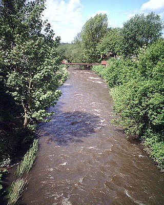
The River Yarrow is in Lancashire, with its source at an area called Will Narr at Hordern Stoops, along Spitlers Edge - the Chorley/Blackburn boundary - on the West Pennine Moors. The river feeds the Yarrow Reservoir, which in turn feeds the Anglezarke and Upper and Lower Rivington Reservoirs. Upon leaving the reservoirs via a pumping station, the river passes through an area that was formerly known as Abyssinia. Currently, this area is within the boundaries of Heath Charnock and Limbrick, but the original name was given because it was a route frequented by coal miners, and the workers were said to look like natives of Abyssinia : until the mid 20th century it was usual for miners to return from work covered in coal dust.
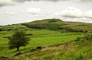
Rivington is a village and civil parish of the Borough of Chorley, Lancashire, England, occupying 2,538 acres. It is about 6 miles (9.7 km) southeast of Chorley and about 8+1⁄2 miles (13.7 km) northwest of Bolton. Rivington is a rural area consisting primarily of agricultural grazing land, moorland, with hill summits including Rivington Pike and Winter Hill within the West Pennine Moors. The area has a thriving tourist industry centred around reservoirs created to serve Liverpool in the Victorian era and Lever Park created as a public park by William Lever at the turn of the 20th century, with two converted barns, a replica of Liverpool Castle and open countryside. Rivington and Blackrod High School is located here. Rivington and its village had a population of 109 at the 2011 Census.

The West Pennine Moors is an area of the Pennines covering approximately 90 square miles (230 km2) of moorland and reservoirs in Lancashire and Greater Manchester, England. It is a Site of Special Scientific Interest.

Puddling is both the material and the process of lining a water body such as a channel or pond with puddle clay – a watertight material based on clay and water mixed to be workable.

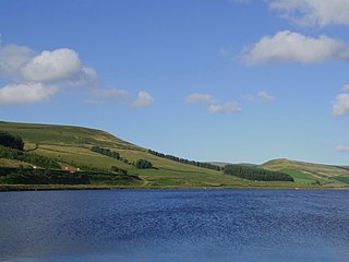
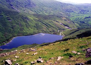
Anglezarke Reservoir is the largest reservoir in the Rivington chain to the west of Anglezarke in Lancashire, England. Anglezarke Reservoir has three embankments: the Charnock Embankment, the longest, is 850 yards (777 m) long and 31 feet (9.45 m) high, the Knowsley Embankment is 240 yards (219.5 m) long and 45 feet (14 m) high and the Heapey Embankment is 280 feet (85.3 m) long and 32 feet (9.75 m) high. It is fed by the River Yarrow, which has been diverted from its original course which is now covered by the Knowsley Embankment. It served the city of Liverpool before its current status as a supply mainly for Wigan. The original `Rivington Pike Scheme' was undertaken by Thomas Hawksley between 1850 and 1857 for the Liverpool Corporation Waterworks. The scheme was to construct five reservoirs and a water treatment works at the south end of Lower Rivington with a 17-mile (27 km) pipeline to storage reservoirs at Prescot. Water from two higher level reservoirs, Rake Brook and Lower Roddlesworth, was carried south in `The Goit', a channel connecting them to the reservoirs.

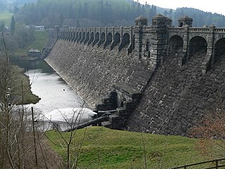
High Bullough Reservoir is the oldest of all the reservoirs in the Rivington chain, having been authorised by an Act of Parliament obtained in 1846 and completed in 1850. It was built for Chorley Waterworks by the engineer John Frederick Bateman, who had estimated the cost of the project while working for Edwin Chadwick's Towns Improvement Company, and had then acted as Engineer for the project. The outlet consisted of a pipe running through the dam, and supported by two masonry piers where it ran through the central clay puddle. The outlet valve was at the downstream end of the dam, and although this configuration is no longer thought to be good practice, there have been no serious issues with the reservoir throughout its operational life. The earth dam had a maximum height of 39 feet (12 m), was 988 feet (301 m) long and impounded 55 million imperial gallons (250 Ml) of water.

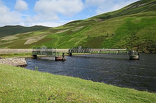
Upper Rivington Reservoir is situated centrally in the Rivington chain of reservoirs, on the West Pennine Moors in Lancashire, England, between Rivington and Anglezarke. The engineer for the Rivington reservoirs was Thomas Hawksley and construction for Liverpool Corporation Waterworks took place between 1852 and 1857. The two dams of the Upper Rivington reservoir are the 292-yard (267 m) Horrobin Embankment that separates it from the lower reservoir and carries a road into the village from the west, and the 292-yard (267 m) long, 40 foot (12.2 m) high Yarrow Embankment.

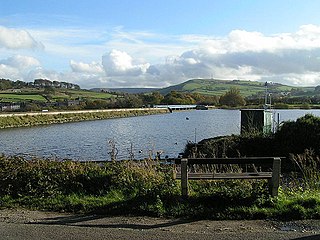
Lower Rivington Reservoir is at the end of the Rivington chain of reservoirs in Lancashire, England, with Upper Rivington Reservoir to the north, and Rivington Water Treatment Works to the south. The Rivington chain primarily supplies 70,000 households in the Wigan area. The chain was built to supply Liverpool.
Woodhead reservoir is a man-made lake near the hamlet of Woodhead in Longdendale in north Derbyshire. It was constructed by John Frederick Bateman between 1847 and June 1877 as part of the Longdendale chain to supply water from the River Etherow to the urban areas of Greater Manchester. It is at the top of the chain of reservoirs and was the first to be started, though, due to construction problems, it was the last to be completed.
Upper Roddlesworth Reservoir is a reservoir on the River Roddlesworth near Abbey Village in Lancashire, England.

The William Girling Reservoir is located in the London Borough of Enfield and is part of the Lee Valley Reservoir Chain that supplies London with drinking water. It is named after William Girling OBE, a chairman of the Metropolitan Water Board (MWB). The reservoir and the nearby King George V Reservoir are known collectively as the Chingford Reservoirs. The storage reservoir, which is owned by Thames Water, is bordered by Chingford to the east and Ponders End and Edmonton to the west, and covers 334 acres with a perimeter of 3.5 miles (5.6 km). There is no public access.

The King George V Reservoir, also known as King George's Reservoir, is located in the London Borough of Enfield and is part of the Lee Valley Reservoir Chain that supplies London with drinking water. The storage reservoir is bordered by Sewardstone and Chingford to the east and Brimsdown and Ponders End to the west, and covers 420 acres, making it the largest in London. The reservoir and the nearby William Girling Reservoir are known collectively as the Chingford Reservoirs, and are owned and managed by Thames Water.
Toddbrook Reservoir, a feeder for the Peak Forest Canal, opened in 1838. It is sited above the town of Whaley Bridge in the Derbyshire High Peak area of England. The reservoir is a Site of Special Scientific Interest (SSSI) providing habitats for herons, ducks and other animals and fish, while rare mosses and liverworts grow on its shores, particularly short-lived species that grow on seasonally exposed mud. The reservoir is used for sailing and angling. The Peak District Boundary Walk runs around the eastern end of the reservoir. The reservoir is owned by the Canal & River Trust and, like the nearby Combs Reservoir, is a feeder reservoir for the Peak Forest Canal. The feeder runs through Whaley Bridge, and with the Combs feed enters the canal system in a pool close to the transhipment shed at the Whaley Bridge canal basin.

The Island Barn Reservoir lies south of the River Thames in England at West Molesey and north of Lower Green, Esher. The reservoir is 122 acres (0.49 km2) large with a capacity of 992 million gallons and is managed by Thames Water. It is within the borough of Elmbridge and is surrounded by the River Mole to the west and the River Ember to the east. Queen Elizabeth II Reservoir is a larger reservoir to the West.
Kentmere Reservoir is a water storage facility situated in the Kentmere valley in the county of Cumbria, England. It is located 10.5 kilometres (6.5 mi) north-northeast of the town of Windermere. The reservoir is fed by the streams which form the headwaters of the River Kent which rise 1.5 kilometres (0.93 mi) to the north in Hall Cove on the southern slopes of a mountainous ridge called High Street, which is named after the nearby Roman road. It is also fed by Lingmell Gill, which drains the large corrie on the western side of Harter Fell beneath the Nan Bield Pass.
Edinburgh Water Company and its successors have provided a public water supply and latterly sewerage and sewage treatment services to the Scottish capital of Edinburgh since 1819. The original company was established to supply drinking water and did so until 1870, when it was taken over by a public Water Trust, with representatives from Edinburgh, Leith and Portobello. That in turn was taken over by Edinburgh Corporation and in 1975, responsibility passed to the Lothian Regional Council, as did the duty to provide sewerage and sewage treatment services. Both services were moved out of local authority control, and taken over by the East of Scotland Water Authority in 1996. The three Scottish regional water authorities were merged to form Scottish Water in 2002.

Liverpool Weir is a heritage-listed weir on the Georges River at Heathcote Road near Newbridge Road, Liverpool, Sydney, New South Wales, Australia. It was designed by David Lennox and built from 1836 by convict labour, directed by Captain W. H. Christie. It is also known as Bourke's Dam. It was added to the New South Wales State Heritage Register on 13 August 2010.
Liverpool Corporation Waterworks and its successors have provided a public water supply and sewerage and sewage treatment services to the city of Liverpool, England. In 1625 water was obtained from a single well and delivered by cart, but as the town grew, companies supplied water to homes through pipes. There were two main companies by the 1840s, but the water supply was intermittent, and there was general dissatisfaction with the service. Liverpool Corporation decided that such an important service should be provided by a public body, and sought to take over the water supply companies.

