Prince Edward Island (PEI) is a province of Canada and one of the three Maritime provinces. It is the smallest province of Canada in both land area and population, but the most densely populated. Part of the traditional lands of the Miꞌkmaq, it was colonized by the French in 1604 and later ceded to the British following the conclusion of the Seven Years War in 1763. It was federated into Canada as a province in 1873. Its capital is Charlottetown.

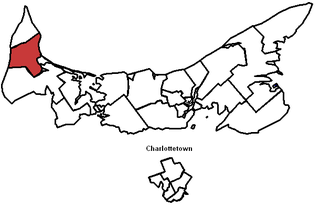
Queens County is a county in the province of Prince Edward Island, Canada. It is the largest county in the province by population with 82,017 (2016), land area, and highest average income. Charlottetown is the county seat of Queens County, and is the largest city and the capital of Prince Edward Island.

Kings County is located in eastern Prince Edward Island, Canada.

Borden-Carleton is a town in Prince County the Canadian province of Prince Edward Island. It is situated on the south shore fronting on the Northumberland Strait. The town was originally incorporated as a community on April 12, 1995, through the amalgamation of the town of Borden and the community of Carleton. The town of Borden opted to demote its status to a community in light of a declining tax base with the pending completion of the Confederation Bridge and the closure of the Marine Atlantic ferry service. Borden-Carleton became a town on July 31, 2012.

Lot 8 is a township in Prince County, Prince Edward Island, Canada. It is part of Halifax Parish. Lot 8 was awarded to Arnold Nisbett (M.P.) in the 1767 land lottery, passed to William Kilpatrick and Benjamin Todd in 1775, and to Todd's heirs in 1783.

Lot 9 is a township in Prince County, Prince Edward Island, Canada. It is part of Halifax Parish. Lot 9 was awarded to James Murray in the 1767 land lottery.

Alberton is a Canadian town located in Prince County, Prince Edward Island. It is situated in the western part of the county in the township of Lot 5. The population was 1,145 as of the 2016 census.

Prince County is located in western Prince Edward Island, Canada. The county's defining geographic feature is Malpeque Bay, a sub-basin of the Gulf of St. Lawrence, which creates the narrowest portion of Prince Edward Island's landmass, an isthmus upon which the city of Summerside is located.
Murray Harbour is a municipality that holds rural municipality status in Prince Edward Island, Canada. It is located in southeastern Kings County.
Morell is a municipality that holds community status in Prince Edward Island, Canada. It is located in Kings County east of Bristol.
Alberton-Roseville was a provincial electoral district for the Legislative Assembly of Prince Edward Island, Canada. It was formerly known as Alberton-Miminegash from 1996 to 2007.

Charlottetown is the capital and largest city of the Canadian province of Prince Edward Island, and the county seat of Queens County. Named after Charlotte of Mecklenburg-Strelitz, queen consort of King George III of the United Kingdom, Charlottetown was an unincorporated town until it was incorporated as a city in 1855.
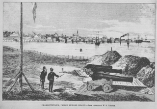
The History of Charlottetown can be traced back to the original French military settlement established on the site in 1720. Over the years Charlottetown has grown to become the largest and most important city on Prince Edward Island.
Linkletter is a municipality that holds community status in Prince Edward Island, Canada. It is located in Prince County.

Resort Municipality, officially named the Resort Municipality of Stanley Bridge, Hope River, Bayview, Cavendish and North Rustico, is the lone municipality in Prince Edward Island, Canada that holds resort municipality status. It was established in 1990.
A resort municipality is a type of municipal status in the Canadian provinces of British Columbia and Prince Edward Island. British Columbia also has a related municipal status type of mountain resort municipality.
Bedeque and Area is a municipality that holds community status in Prince Edward Island, Canada. It was formed through the amalgamation of the communities of Bedeque and Central Bedeque on November 17, 2014. It had a population of 310 in 2011.
