Malpeque Bay, Prince Edward Island

Last updated

Rural Municipality of Malpeque Bay
Canada Prince Edward Island location map 2.svg
Red pog.svg
Rural Municipality of Malpeque Bay
Coordinates: 46°30′N63°40′W / 46.500°N 63.667°W / 46.500; -63.667
CountryCanada
Province Prince Edward Island
County Prince County
Queens County
Parish St. David's Parish
Grenville Parish
Incorporated1973
Government
  TypeMunicipal Council
  MayorPaul Brown
  CouncillorsBrian McKinnon
Krista Ashley
Wayne Crosby
Ghislaine Duplain
Jason MacLellan
Marla Simmons [1]
  Seat Malpeque
Population
  Total1,191
Time zone UTC-4 (AST)
  Summer (DST) UTC-3 (ADT)
Canadian Postal code
C0B 1M0
Area code 902

The Municipality of Malpeque Bay is a municipality that holds community status in Prince Edward Island, Canada. [2] It is located in Prince County and Queens County.

Contents

The municipality derives its name from Malpeque Bay, the second largest bay in the province which forms the municipality's western boundary. The municipality straddles several levels of geographic hierarchy in the province, including the townships of Lot 18 and Lot 20, the parishes of St. David's Parish and Grenville Parish, as well as the counties of Prince County and Queens County.

The municipality's seat is in the community of Malpeque.

History

The area was originally settled by the Mi'kmaq around 2500 BC. The Mi'kmaq called the area "Makpaak", meaning "large bay". [3]

Acadian families arrived from Nova Scotia in 1728 and settled on the west shore of Malpeque Bay, north of present-day Miscouche, naming their settlement "Malpèque" after the Mi'kmaq name. By 1752, the settlement housed a population of more than 200. [4] [5] In 1758, the expulsion of the Acadians began after the fall of Louisbourg. According to local tradition, when the Malpèque settlers learned of the British arrival at Port-LaJoye, they stripped their church and buried the chapel bell to hide it from British capture. [6]

In his 1764 survey of the colony, British surveyor Samuel Holland assigned an area on the east shore of the bay as Crown land. Named Prince Royalty for the newly born Prince George (later George IV), nearby Princetown was intended to become the seat of Prince County. [3] [7] Princetown's harbour proved unfavourable for large ships, and saw only limited rural development due to being surrounded by Crown land, thus the townsite failed to develop, and the Acadian name remained well known for the area. [8] A more favourable sheltered harbour was located on the south side of the island, which later became Summerside.

Princetown was officially incorporated as a town in 1901, but its status was downgraded to settlement in 1925. The settlement's name officially became Malpeque on 13 March 1947. In 1973, Malpeque was designated a locality within the newly established Community of Malpeque Bay. [9]

Communities

This municipality contains the following communities:

Lot 18

Lot 20

Demographics

Federal census population history of Malpeque Bay
YearPop.±%
2016 1,030    
2021 1,191+15.6%
Source: Statistics Canada [10]

In the 2021 Census of Population conducted by Statistics Canada, Malpeque Bay had a population of 1,191 living in 520 of its 991 total private dwellings, a change of

Related Research Articles

<span class="mw-page-title-main">Nova Scotia</span> Province of Canada

Nova Scotia is one of the thirteen provinces and territories of Canada. It is one of the three Maritime provinces and one of the four Atlantic provinces. Nova Scotia is Latin for "New Scotland".

Windsor is a community located in Hants County, Nova Scotia, Canada. It is a service centre for the western part of the county and is situated on Highway 101.

Central Bedeque is a former municipality that previously held community status in the Canadian province of Prince Edward Island. It was dissolved through its amalgamation with the Community of Bedeque on November 17, 2014 to create the Community of Bedeque and Area. It is located north of Borden-Carleton within Lot 26, Prince County. Its primary industry is agriculture.

<span class="mw-page-title-main">Tignish, Prince Edward Island</span> Town in Prince Edward Island, Canada

Tignish is a Canadian town located in Prince County, Prince Edward Island.

<span class="mw-page-title-main">Shippagan</span> Town in New Brunswick, Canada

Shippagan is a Canadian town within Shippegan Parish, Gloucester County, New Brunswick.

<span class="mw-page-title-main">Souris, Prince Edward Island</span> Town in Prince Edward Island, Canada

Souris is a town in Kings County, Prince Edward Island, Canada. It is located near the northeastern tip of the province.

<span class="mw-page-title-main">Prince Royalty, Prince Edward Island</span>

Prince Royalty is the royalty for Prince County, Prince Edward Island, Canada.

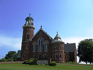
Alberton is a Canadian town located in Prince County, Prince Edward Island. It is situated in the western part of the county in the township of Lot 5.

<span class="mw-page-title-main">Prince County, Prince Edward Island</span> Place

Prince County is located in western Prince Edward Island, Canada. The county's defining geographic feature is Malpeque Bay, a sub-basin of the Gulf of St. Lawrence, which creates the narrowest portion of Prince Edward Island's landmass, an isthmus upon which the city of Summerside is located.

<span class="mw-page-title-main">Georgetown, Prince Edward Island</span> Place in Prince Edward Island, Canada

Georgetown is a community located within the municipality of Three Rivers in Kings County, Prince Edward Island, Canada. It is the Capital of Kings County. Previously incorporated as a town, it amalgamated with the town of Montague, the rural municipalities of Brudenell, Cardigan, Lorne Valley, Lower Montague, and Valleyfield, and portions of three adjacent unincorporated areas in 2018.

<span class="mw-page-title-main">Miscouche</span> Place in Prince Edward Island, Canada

Miscouche is a municipality that holds community status in Prince Edward Island, Canada. It is located in Prince County.

<span class="mw-page-title-main">Morell, Prince Edward Island</span> Rural municipality in Prince Edward Island, Canada

Morell is a rural municipality in Prince Edward Island, Canada. It is located in Kings County east of Bristol.

Lennox Island is an island located in Malpeque Bay off the northwest coast of Prince Edward Island, Canada. Connected by a short causeway and bridge, Lennox Island is home to the Lennox Island First Nation, of the Mi'kmaq people. The Mi'kmaq name for the island is L'nui Minegoo, and it has been informally known by European settlers as Indian Island.

Abram-Village is a rural municipality in Prince County, Prince Edward Island, Canada.

<span class="mw-page-title-main">Skmaqn–Port-la-Joye–Fort Amherst</span> Historic site in Anchor Point in the community of Rocky Point, Prince Edward Island.

Skmaqn–Port-la-Joye–Fort Amherst is a National Historic Site located in Rocky Point, Prince Edward Island.

Flat Bay is a local service district and designated place in the Canadian province of Newfoundland and Labrador. It is a Mi'kmaq community in southwestern Newfoundland.

<span class="mw-page-title-main">Pisiguit</span>

Pisiguit is the pre-expulsion-period Acadian region located along the banks of the Pisiquit River from its confluence with the Minas Basin of Acadia, which is now Nova Scotia, including the St. Croix River drainage area. Settlement in the region commenced simultaneous to the establishment of Grand-Pré. Many villages spread rapidly eastward along the river banks. These settlements became known as Pisiguit or. The name is from the Mi'kmaq Pesaquid, meaning "Junction of Waters". In 1714, there were 351 people there.

<span class="mw-page-title-main">Outline of Nova Scotia</span> Overview of and topical guide to Nova Scotia

The following outline is provided as an overview of and topical guide to Nova Scotia:

Old Princetown Road is an historic colonial road in the Canadian province of Prince Edward Island. Dating to at least 1771, the approximately 59-kilometre (37 mi) road was an important inland commercial and military route connecting the town of Princetown or Malpeque with the colonial capital at Charlottetown. A large part of the former road is now in use as Route 2 between Charlottetown and Hunter River, while other parts remain as gravel roads or dirt paths, and some portions have been replaced entirely by farmland. A short section near South Granville is listed on the Canadian Register of Historic Places.

Spring Bay is a rural community in Lot 18, Prince County, Prince Edward Island, Canada. Spring Bay is part of the incorporated municipality of Malpeque Bay.

References

  1. "Contact Us | BUSINESS NAME".
  2. "Municipal Councils and Contact Information" (PDF). Government of Prince Edward Island. January 27, 2017. Retrieved February 4, 2017.
  3. 1 2 "The Community of Malpeque Bay History". malpequebay.ca. Retrieved 23 May 2014.
  4. Day, Jim (6 September 2014). "Great find on P.E.I." The Guardian. Retrieved 28 September 2016.
  5. "Sieur de la Rocque 1752 Census for Prince Edward Island/Ile Saint Jean". The Island Register. Retrieved 28 September 2016.
  6. "A Legend in P.E.I. - Chapel Bells Buried For Two Centuries". Yarmouth Vanguard. 6 March 1990. Retrieved 28 September 2016.
  7. Campbell, Duncan (1875). History of Prince Edward Island. Charlottetown: Bremner Brothers. p. Chapter 1.
  8. "Accounts and Papers: Thirty Volumes". 34. 1849: 63. Retrieved 28 September 2016.{{cite journal}}: Cite journal requires |journal= (help)
  9. "PlaceFinder: Malpeque". Government of Prince Edward Island. Retrieved 28 September 2016.
  10. 1 2 "Population and dwelling counts: Canada, provinces and territories, and census subdivisions (municipalities), Prince Edward Island". Statistics Canada. February 9, 2022. Retrieved March 3, 2022.