
Queens County is a county in the province of Prince Edward Island, Canada. It is the largest county in the province by population with 82,017 (2016), land area, and highest average income. Charlottetown is the county seat of Queens County, and is the largest city and the capital of Prince Edward Island.

Kings County is located in eastern Prince Edward Island, Canada.

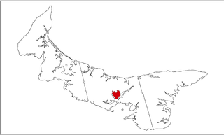
Cavendish is an unincorporated rural community in the township of Lot 23, Queens County, Prince Edward Island, Canada.

Skinners Pond is a rural unincorporated community in Prince County, Prince Edward Island, Canada.

Foxley River is a Canadian rural community in Prince County, Prince Edward Island.
St. Felix is a municipality that holds community status in Prince Edward Island, Canada. It is located in Prince County, 4 km (2.5 mi) south of Tignish.
Alberton is a Canadian town located in Prince County, Prince Edward Island. It is situated in the western part of the county in the township of Lot 5. The population was 1,145 as of the 2016 census.

Prince County is located in western Prince Edward Island, Canada. The county's defining geographic feature is Malpeque Bay, a sub-basin of the Gulf of St. Lawrence, which creates the narrowest portion of Prince Edward Island's landmass, an isthmus upon which the city of Summerside is located.
Murray Harbour is a municipality that holds rural municipality status in Prince Edward Island, Canada. It is located in southeastern Kings County.
Miminegash is a municipality that holds community status in Prince Edward Island, Canada. It is located 8 miles (13 km) northwest of Alberton and 11 miles (18 km) southwest of Tignish. It is part of a small area in Lot 3 known as either the St. Louis, Palmer Road, or Miminegash area. This area is often associated with Tignish due to the shared Acadian roots between these areas.
Morell is a municipality that holds community status in Prince Edward Island, Canada. It is located in Kings County east of Bristol.
Sherwood is a neighbourhood of the city of Charlottetown in central Queens County, Prince Edward Island, Canada.
Tyne Valley is a municipality that holds community status in Prince Edward Island, Canada. It is located in Prince County. Incorporated in 1966, the community is located in the township of Lot 13 at the intersection of Routes 12 and 167.
Wellington is a municipality that holds community status in Prince Edward Island, Canada. It is located in Prince County, and extends as Wellington Centre onto Route 2 from Richmond through to St. Nicholas.
Abram-Village is a Canadian rural municipality located in Prince County, Prince Edward Island.
West Cape is a cape and an unincorporated community located at the westernmost extremity of Prince Edward Island, Canada.
Knutsford is a neighbourhood of the City of Kamloops, British Columbia, Canada, located on the south side of that city just west of Peterson Creek. It is named for Knutsford, Cheshire, by Robert Longridge, who took up ranching in the area in 1912.
Greenmount is a municipality that holds community status in Prince Edward Island, Canada.
Roxbury, a community of Lot 6 is a settlement in Prince Edward Island.
Mont Carmel is a Canadian unincorporated area in Prince County, Prince Edward Island. The community is located in the "Evangeline Region" which is a cluster of Acadian communities in the central part of Prince County. The village is home to the Notre-dame-du-Mont-Carmel, a massive 450000-brick Catholic church built in 1898.
