
Suldal is a municipality in the northeast corner of Rogaland county, Norway. It is located in the traditional district of Ryfylke. Since 1965, the administrative centre of Suldal is the village of Sand i Ryfylke. Other villages in Suldal include Haugsland, Jelsa, Marvik, Nesflaten, and Suldalsosen.
Bykle is a municipality in Agder county, Norway. It is located in the traditional district of Setesdal. The administrative centre of the municipality is the village of Bykle. Other villages in Bykle municipality include Berdalen, Bjåen, Breive, Hoslemo, Hovden, and Nordbygdi. Bykle was established as a municipality on 1 January 1902 when it was separated from the municipality of Valle.
Vatndalsvatnet or Vatnedalsvatnet is a lake in the municipality of Bykle in Agder county, Norway. The 14.42-square-kilometre (5.57 sq mi) lake lies about 3 kilometres (1.9 mi) west of the village of Berdalen and the river Otra. The nearby lakes Ormsavatnet and Store Urevatn flow into the lake through dams and canals. The lake Vatndalsvatnet also has a dam on it and the water flows out of the lake from the dam into the Otra river. The lake is located in the central part of Bykle, about halfway between the villages of Hovden and Bykle. The mountains Snjoheinuten and Kvervetjønnuten both lie on the south side of the lake.
Ormsavatnet is a lake in the municipality of Bykle in Agder county, Norway. The 3.11-square-kilometre (1.20 sq mi) lake flows into the Vatndalsvatnet via a dam and canal. The lake is located in the Setesdalsheiene mountains near the lakes Store Urevatn, Holmevatnet, and Hartevatnet. The nearest village area is Hovden, about 14 kilometres (8.7 mi) to the northeast. The mountain Kaldafjellet lies about 5 kilometres (3.1 mi) to the west of the lake.
Reinevatn is a lake in the municipality of Bykle in Agder county, Norway. The 2.86-square-kilometre (1.10 sq mi) lake is located south of the lakes Store Urevatn and Vatndalsvatnet in the Setesdalsheiene mountains in the Setesdal valley, about 10 kilometres (6.2 mi) northwest of the village of Bykle. The lake has a dam on the southern edge which keeps the water level at an elevation of 1,170 metres (3,840 ft) above sea level. The dam's spillway flows into the nearby river Skargjesåni. The Snjoheinuten mountain lies just to the northeast of the lake.

Hartevatnet or Hartevatn is a lake in the municipality of Bykle in Agder county, Norway. It is located along the river Otra, on the south side of the village of Hovden. The lake is a good fishing spot and contains many brown trout. The Norwegian National Road 9 runs along the eastern shore of the lake. The lake Skyvatn lies about 6 kilometres (3.7 mi) to the northwest and the lake Holmavatnet lies about 13 kilometres (8.1 mi) to the northwest.
Holmevatnet or Holmevatn is a lake in the Setesdalsheiene area of Norway. It is located in the mountains on the border of the municipalities of Bykle in Agder county and Suldal in Rogaland county. The 4.76-square-kilometre (1.84 sq mi) lake lies just west of the lake Store Urevatn and to the northeast of the lake Blåsjø. The nearest villages are Berdalen in Bykle, about 20 kilometres (12 mi) to the east and Suldalsosen, about 30 kilometres (19 mi) to the west. The mountain Kaldafjellet lies about 6 kilometres (3.7 mi) north of the lake.
Botsvatn or Bossvatn is a lake in the municipality of Bykle in Agder county, Norway. The 14.6-kilometre (9.1 mi) long, narrow reservoir is located just to the southeast of the large lake Blåsjø and northeast of the lake Ytre Storevatnet. The lake holds water for the Brokke Hydroelectric Power Station, located in nearby Valle municipality. The water from the lake can flow out into the nearby river Otra, but only when water is released from the dam.
Skyvatn is a lake in the northern part of the municipality of Bykle in Agder county, Norway. The lake is located south of the lake Holmavatnet and northwest of the lake Hartevatnet. The village of Hovden in Bykle is the nearest village, located about 9 kilometres (5.6 mi) southeast of the lake.
Store Urevatn or Urevatn is a lake in the municipality of Bykle in Agder county, Norway. The 14.61-square-kilometre (5.64 sq mi) lake lies about 13 kilometres (8.1 mi) west of the village of Hoslemo and about 15 kilometres (9.3 mi) northwest of the municipal centre of Bykle. The lake sits at an elevation of 1,164 metres (3,819 ft) above sea level, high up in the Setesdalsheiene mountains, just north of the mountains Urevassnutene and Djuptjønnuten and just west of Snjoheinuten.
Ytre Storevatnet is a lake in the municipality of Bykle in Agder county, Norway. The 2.8-square-kilometre (1.1 sq mi) lake makes up the northernmost part of the Svartevatnet reservoir that empties into the Sira River system. The lake is located just south of the lake Blåsjø and southwest of Botsvatn. The village of Bykle is about 25 kilometres (16 mi) northeast of the lake.
Sæbyggjenuten is a mountain on the border of Agder and Telemark counties in southern Norway. The 1,507-metre (4,944 ft) tall mountain is the highest point in Bykle municipality as well as for all of Agder county, and in the whole region of Southern Norway (Sørlandet). The mountain sits on the border of the municipalities of Bykle and Tokke. It is located about 20 kilometres (12 mi) west of Dalen in Vestfold og Telemark and also about 20 kilometres (12 mi) northeast of the village of Bykle in Agder.
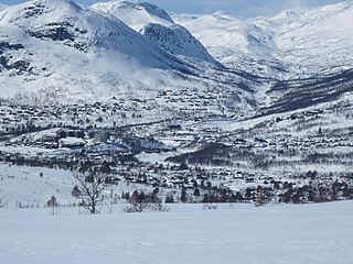
Hovden is a village in the municipality of Bykle in Agder county, Norway. It is located in the northern part of Setesdalen valley, on the Norwegian National Road 9 and the river Otra, on the eastern shore of the lake Hartevatnet. The village sits about 25 kilometres (16 mi) north of the village of Bykle and about 4 kilometres (2.5 mi) east of the village of Breive. The 0.57-square-kilometre (140-acre) village has a population (2019) of 413 and a population density of 726 inhabitants per square kilometre (1,880/sq mi). Fjellgardane Church is located in Hovden.
Skyvassnuten is a mountain in the municipality of Bykle in Agder county, Norway. The 1,421-metre (4,662 ft) tall mountain sits just 1.2 kilometres (0.75 mi) east of the municipal/county border with Rogaland. The lake Skyvatn lies at the eastern foot of the mountain and the mountain Sveigen lies immediately south of the mountain. The lake Holmavatnet lies about 5 kilometres (3.1 mi) north of the mountain.
Steinheii is a mountain in the municipality of Bykle in Agder county, Norway. The 1,421-metre (4,662 ft) tall mountain has a topographic prominence of 260 metres (850 ft) which makes it the 10th highest mountain in Agder county. The mountain sits in the southwestern part of the municipality, just south of the lake Botsvatn and east of the lake Ytre Storevatnet. The nearest village is Bykle, located about 15 kilometres (9.3 mi) to the northeast.
Storheddernuten or Storhidlernuten is a mountain on the border of Agder and Rogaland counties in southern Norway. The 1,402-metre (4,600 ft) tall mountain has a topographic prominence of 70 metres (230 ft). The mountain sits on the border of the municipalities of Suldal in Rogaland and Bykle in Agder. The mountain is the 21st highest mountain in Agder county.

Ulla-Førre is a hydropower complex in Southern Norway. It is situated along the borders of the municipalities of Suldal and Hjelmeland and Bykle, Norway. It has an installed capacity of approximately 2,100 megawatts (2,800,000 hp), and the annual average production is 4.45 TWh (16.0 PJ) (1987–2006), while its reservoir capacity is about 7.8 TWh (28 PJ); at full production, it can last seven to eight months. The complex includes the artificial lake Blåsjø, which is made by dams around 1,000 metres (3,300 ft) above the sea level. The hydroelectric power stations in the complex are Saurdal, Kvilldal, Hylen and Stølsdal, operated by Statkraft.

Norwegian National Road 9 is often called the Setesdal Road and it is the main thoroughfare through the Setesdalen valley. It runs from the city of Kristiansand in the southern coast of Norway, through the Torridal and Setesdal valleys in Agder county to Haukeligrend in Vestfold og Telemark county in the north where it meets the European route E134 highway. The highway goes through the villages of Mosby, Homstean, Skarpengland, Hægeland, Hornesund, Hornnes, Evje, Byglandsfjord, Bygland, Ose, Rysstad, Valle, Flatland, Rygnestad, Bykle, Hovden, Bjåen, and Haukeli.
Bjåen or Bjåi is a small village in Bykle municipality in Agder county, Norway. The village is located along the Norwegian National Road 9. The village sits on the north shore of the lake Breidvatn, about 12 kilometres (7.5 mi) north of the village of Hovden and about 15 kilometres (9.3 mi) south of Haukeli in neighboring Vinje municipality in Vestfold og Telemark county to the north. The area is primarily agricultural, specializing in sheep herding rather than growing crops, but Bjåen is probably best known for the Bjåen tourist lodge in the high mountain area.
Kaldafjellet is a mountain on the border of Agder and Rogaland counties in southern Norway. The mountain lies on the border of the municipality of Suldal and the municipality of Bykle. The mountain has two peaks: the eastern one lies on the municipal-county border reaching 1,452 metres (4,764 ft), while the highest point on the mountain lies less than 1 kilometre (0.62 mi) to the west, reaching a peak of 1,480 metres (4,860 ft). The prominence of the mountain is 210 metres (690 ft) and the isolation is 4.2 kilometres (2.6 mi).


