
Buskerud is a county and a current electoral district in Norway, bordering Akershus, Oslo, Oppland, Sogn og Fjordane, Hordaland, Telemark and Vestfold. The region extends from the Oslofjord and Drammensfjorden in the southeast to Hardangervidda mountain range in the northwest. The county administration was in modern times located in Drammen. Buskerud was merged with Akershus and Østfold into the newly created Viken County on 1 January 2020. On the 23 February 2022 Viken County Council voted in a 49 against 38 decision to submit an application to the Norwegian government for a county demerger. Due to this, Buskerud was re-established in 2024.

Hol is a municipality in Buskerud county, Norway.

The Bergen Line or the Bergen Railway, is a 371-kilometre (231 mi) long scenic standard gauge railway line between Bergen and Hønefoss, Norway. The name is often applied for the entire route from Bergen via Drammen to Oslo, where the passenger trains go, a distance of 496 kilometres (308 mi). It is the highest mainline railway line in Northern Europe, crossing the Hardangervidda plateau at 1,237 metres (4,058 ft) above sea level.
Bergkrystallen is the end station on the Lambertseter Line, after Munkelia, of the Oslo Metro. It is located in the Nordstrand borough. Bergkrystallen is a road just north of the station. The area is mainly residential. Originally it was planned to extend the Lambertseter Line to Mortensrud, but the Østensjø Line was extended instead. The station is served by Line 4.

Jar is a station served both by the Oslo Metro and the Oslo Tramway located in Bærum, just west of Lysakerelva which divides Oslo and Bærum. The track is shared, the tram line joins with the rapid transit line on the Oslo side of the river. The station had a yellow penthouse and contained a newspaper outlet. However, after the reconstruction, the penthouse was reinstated but has a different colour.
The larger Kvernaland area is an amalgamation of villages in Rogaland county, Norway. The village is located along the north end of the lake Frøylandsvatnet. The village is located in both the municipalities of Klepp and Time. The eastern part of the village is also known as Orstad and the western part of the village is known as Frøyland or simply as Kvernaland. The village of Klepp stasjon lies just southwest of the village on the west side of the lake and the small village of Foss Eikjeland lies just north of the village, along the river Figgjo.

Frøylandsvatnet is a lake in Rogaland county, Norway. The 4.83-square-kilometre (1.86 sq mi) lake is located in the district of Jæren. It forms part of the municipal boundary line between Klepp and Time. The lake is quite shallow, with an average depth of 5.5 metres (18 ft).
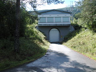
Nygardsvatnet is a lake in the municipality of Hol in Viken county, Norway. The lake is situated south of the Hallingskarvet mountain range. The lake serves as a reservoir for Usta kraftverk, a hydroelectric plant which was put into operation in 1965. The water level is controlled by a dam at the outlet and a tunnel down to lakes Sløddfjorden and Ustevatn. The Usta kraftverk power plant is owned and operated by E- CO Energi.
Ørteren is a lake in the municipality of Hol in Buskerud county, Norway.

Rødungen is a lake in Buskerud County, Norway. The lake is located on the border between the municipalities of Ål and Nore og Uvdal. Waterfall from the lake is a power source for Usta kraftverk, a hydro-electric plant. The power station exploits the fall of the Usta River from Rødungen as well as Ustevatn. The plant started production in 1965 and is owned and operated by E- CO Energi.

Hen is a small village in the municipality of Ringerike in Buskerud, Norway.

Haugastøl is a station on the Bergen Line in Norway. The station is located in the Hol municipality situated between the stations Ustaoset to the east and Finse to the west. The station is 275.50 kilometres (171.19 mi) from Oslo if one follows the track over Roa. The altitude is 988 metres (3,241 ft) above sea level.

Nelaug Station is a railway station located at the village of Nelaug in Åmli municipality in Agder county, Norway. The station sits just north of the lake Nelaug. The station functions as a meeting station of the Sørlandsbanen and Arendalsbanen railway lines. The Arendalsbanen line is a branch line that runs from Nelaug to Arendal Station. Passengers from Oslo to Arendal must change trains at Nelaug. The station was opened on 10 November 1910, and in 1935, a new building was completed.

Sandefjord Station is a railway station on the Vestfold Line in Sandefjord, Norway. The station is served with regional trains operated by Vy. The station opened as part of the Vestfold Line in 1881. Norsk Spisevognselskap took over operations of the restaurant on 1 January 1940. The first train came to Sandefjord in 1881, on its way to neighboring Larvik. In the 1950s, the steam locomotive was replaced by the less noisy electric run train.

Kornsjø Station is a railway station located at Kornsjø in Halden, Norway, on the Østfold Line. The station is located 1 kilometre (0.62 mi) from the Norway–Sweden border and was opened in 1879 for changing crew on international trains between Sweden and Norway and for the customs office. The building was destroyed by fire in 1898 and a new larger stone building was built. The restaurant was taken over by Norsk Spisevognselskap from 1 August 1924, but was then privatized from 1932. The signal equipment connected to the station is fully Norwegian, but some of it is located on the Swedish side.
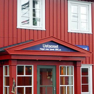
Ustaoset Station is a railway station located at Ustaoset in Hol, Norway. The station is served by up to seven daily express trains operated by Vy Tog. The station was opened in 1912 when cabin building started in the area. Ustaoset is primarily a recreational area, with 900 cabins.

Voss Station is a railway station on the Bergen Line located in the village of Vossevangen in the municipality of Voss in Vestland county, Norway. It sits just off the European route E16 highway on the northwestern shore of the lake Vangsvatnet.
Usta or Usteåne is a river located in the municipality of Hol in Buskerud, Norway. It flows from Lake Ustevatn traveling northeast down the valley of Ustedalen to its confluence with Holselva. The ski resort at Geilo is situated just north of the river, about halfway down Ustedalen valley. The valley stretches about 20 kilometres (12 mi) east from Ustevatn and meetings Holsdalføret below Hagafoss.

Norwegian National Road 7 is a national road in Norway which runs from the town of Hønefoss in Buskerud county to the village of Granvin in Vestland county. The route is 387.6 kilometres (240.8 mi) long and runs east–west through Viken and Vestland counties over the vast Hardangervidda plateau.
Taugevatn is a lake on the south side of the Bergen Line in Ulvik municipality in Vestland county, Norway. It sits at 1,296 metres (4,252 ft) above sea level. The railway had its summit here, at 1,301.7 metres (4,271 ft) above sea level, until the Finse Tunnel was built which led to the closure of the route past the lake on 16 May 1993. After the tunnel opened, the highest point on the line became 1,237 metres (4,058 ft) above sea level, at kilometre 306.90 inside the tunnel.

