
Vestre Slidre is a municipality in Innlandet county, Norway. It is located in the traditional district of Valdres. The administrative centre of the municipality is the village of Slidre. Other villages in Vestre Slidre include Lomen and Røn.

Øystre Slidre is a municipality in Innlandet county, Norway. It is located in the traditional district of Valdres. The administrative centre of the municipality is the village of Heggenes. Other villages in the municipality include Hegge, Rogne, Volbu, Moane, Skammestein, Beito, and Beitostølen.

The Ofotfjord (English), Ofotfjorden (Norwegian), or Ufuohttá (Northern Sami) is a fjord in Nordland county, Norway. It is an inlet of the Norwegian Sea, located about 200 kilometres (120 mi) north of the Arctic Circle. The 78-kilometre (48 mi) long Ofotfjord is Norway's 12th longest fjord and it is also the 18th deepest, with a maximum depth of 553 metres (1,814 ft). In the English language and in many historical documents, this fjord is often referred to as the Narvik Fjord because the town of Narvik is located on the inner shores of the fjord, but this is not an official name of the fjord.

Snåsavatnet is Norway's sixth-largest lake. The 126-square-kilometre (49 sq mi) lake is located in the municipalities of Steinkjer and Snåsa in Trøndelag county, Norway. The villages of Følling and Sunnan lie at the southwestern end of the lake and the village of Snåsa lies at the northeastern end of the lake. European route E6 runs along the northern shore of the lake and the Nordland Line runs along the southern shore.
Moane is a village in Øystre Slidre Municipality in Innlandet county, Norway. The village is located on the east side of the river Volbuelve, on a hillside between the lakes Heggefjorden and Volbufjorden. The village of Heggenes lies about 3 kilometres (1.9 mi) to the northwest, the village of Volbu lies about 2 kilometres (1.2 mi) to the west, and the village of Rogne lies about 3.5 kilometres (2.2 mi) to the southeast. The Norwegian County Road 51 runs through the village.

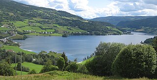
Røn is a village in Vestre Slidre Municipality in Innlandet county, Norway. The village is located where the Slidrefjorden and the Strondafjorden meet, about 8 kilometres (5.0 mi) south of the village of Slidre. The European route E16 highway runs through the village. The 0.49-square-kilometre (120-acre) village has a population (2021) of 260 and a population density of 536 inhabitants per square kilometre (1,390/sq mi).

Vinstre is a lake in Innlandet county, Norway. The 27.87-square-kilometre (10.76 sq mi) lake lies in Øystre Slidre Municipality and the very western tip of the lake crosses over into the neighboring Vang Municipality. The lake sits at an elevation of 1,032 metres (3,386 ft) above sea level. Vinstre was regulated in connection with the construction of the Øvre Vinstra hydroelectric power plant. The lake Bygdin flows into this lake and on the opposite end, it flows out into the dammed lake Sandvatnet/Kaldfjorden/Øyvatnet which is the headwaters for the river Vinstra.
Sandvatnet or Kaldfjorden or Øyvatnet is a lake in Innlandet county, Norway. The 19.18-square-kilometre (7.41 sq mi) lake is rather unique because it has three parts and each part has a different name. Sandvatnet is the western part, Kaldfjorden is the central portion and Øyvatnet is the eastern part. The lake lies in Nord-Fron, Sør-Fron and Øystre Slidre municipalities.
Strondafjorden is a lake which lies in the municipalities of Nord-Aurdal and Vestre Slidre in Innlandet county, Norway. The lake is part of the Begna watershed. The 13.4-square-kilometre (5.2 sq mi) lake sits at an elevation of 355 metres (1,165 ft) above sea level and it has a circumference of 46 kilometres (29 mi). The town of Fagernes is located at the southeast end of the lake.

Helin is a lake which lies in Vang Municipality in Innlandet county, Norway. The southeastern shore of the lake forms the municipal border with neighboring Vestre Slidre. The lake is regulated for power production by the nearby Åbjøra hydroelectric power station.
Vostervatnet is a lake in the municipality of Strand in Rogaland county, Norway. The 2.62-square-kilometre (1.01 sq mi) lake lies in the northwestern part of Strand, just south of the Fognafjorden. The village of Tau lies about 3.5 kilometres (2.2 mi) southwest of the lake. The main outflow of the lake is the river Fiskåna, which flows north from the northeastern corner of the lake, down the hill to the village of Fiskå on the shore of the fjord.

Herefossfjorden is a lake in the municipality of Birkenes in Agder county, Norway. The 3.7-square-kilometre (1.4 sq mi) lake is about 9 kilometres (5.6 mi) long and it is part of the Tovdalselva river. The Gauslåfjorden and Uldalsåna lakes flow into Herefossfjorden near the village of Herefoss at the northern end of the lake. The Uldalsåna lake is held back by a dam and the Gauslåfjorden flows over a waterfall into the Herefossfjorden. The Norwegian National Road 41 runs along the eastern shore. The village of Herefoss lies on the northern edge of the lake and the village of Søre Herefoss lies at the southern end of the fjord. The old municipality of Herefoss existed from 1838 until 1967 and it included all the land surrounding the lake.
Eidfjordvatnet is a moraine-dammed lake in the municipality of Eidfjord in Vestland county, Norway. The 3.55-square-kilometre (1.37 sq mi) lake is located immediately southeast of the village of Eidfjord. Øvre Eidfjord village lies on the southern shore of the lake. Norwegian National Road 7 runs along the western shore of the lake. The water enters the lake through the Bjoreio and Veig rivers, and the water empties from the lake through the Eio River.
Øyangen is a lake in Innlandet county, Norway. The 6.644-square-kilometre (2.565 sq mi) lake lies on the border of the municipalities of Øystre Slidre, Vestre Slidre, and Vang. The lake lies about 5 kilometres (3.1 mi) to the south of the village of Beitostølen and about 5 kilometres (3.1 mi) to the northwest of the village of Skammestein. The lake is regulated for hydroelectric power generation. It serves as a reservoir for the nearby Lomen power plant.
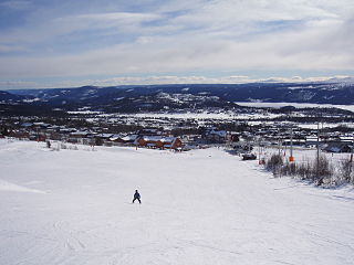
Beitostølen is a village in Øystre Slidre Municipality in Innlandet county, Norway. The village is located at an elevation of about 900 meters (3,000 ft) above mean sea level on the southern edge of the Valdresflye mountain plateau. The villages of Skammestein and Hegge lie about 10 kilometres (6.2 mi) to the southeast of Beitostølen. The lake Øyangen lies a short distance to the southwest of the village. The Norwegian County Road 51 runs through the village.

Heddalsvatnet is a lake in Notodden Municipality and Midt-Telemark Municipality in Telemark county, Norway. The 13.2-square-kilometre (5.1 sq mi) lake is located just south of the town of Notodden. The village of Heddal and the Heddalen valley are located to the northwest of the lake.

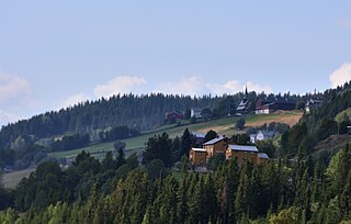
Skammestein is a village in Øystre Slidre Municipality in Innlandet county, Norway. The village is located on a hillside overlooking the east shore of the lake Hedalsfjorden. The village of Beitostølen lies about 7 kilometres (4.3 mi) to the northwest and the villages of Hegge and Heggenes are located about 7 kilometres (4.3 mi) to the southeast. Lidar Church is located in the village, along the Norwegian County Road 51.
Hegge is a village in Øystre Slidre Municipality in Innlandet county, Norway. The village is located on a hillside overlooking the north shore of the lake Heggefjorden. The village of Heggenes lies about 3.5 kilometres (2.2 mi) to the southeast and the village of Skammestein lies about 5 kilometres (3.1 mi) to the northwest. The Norwegian County Road 51 runs through the village. The medieval Hegge Stave Church is located in the rural village.

Heggenes is the administrative centre of Øystre Slidre Municipality in Innlandet county, Norway. The village is located on the east shore of the lake Heggefjorden. The village of Hegge lies about 3 kilometres (1.9 mi) to the northwest, the village of Volbu lies about 3 kilometres (1.9 mi) to the south, and the village of Moane lies about 2.5 kilometres (1.6 mi) to the southeast. The Norwegian County Road 51 runs through the village.

Lomen is a village in Vestre Slidre Municipality in Innlandet county, Norway. The village is located at the north end of the Slidrefjorden, about 4 kilometres (2.5 mi) to the east of the village of Ryfoss and about 8 kilometres (5.0 mi) to the northwest of the village of Slidre. The historic Lomen Stave Church and the newer Lomen Church are both located in the village. The European route E16 highway runs through the village. The Lomen power plant is located on the west end of the village.


