
Kvinesdal is a municipality in Agder county, Norway. It is located in the traditional district of Lister. The administrative centre of the municipality is the village of Liknes. Other villages in Kvinesdal include Feda, Fjotland, and Storekvina.

Sirdal is a municipality in Agder county, Norway. It is located in the northwestern part of the traditional district of Lister. The administrative centre of the municipality is the village of Tonstad. Other villages in Sirdal include Bjørnestad, Haughom, Kvæven, Lunde, and Tjørhom.
Sira is a village in Flekkefjord municipality in Agder county, Norway. The village is located immediately east of the county border of Agder and Rogaland. The European route E39 highway passes by the village and the Sørlandet Line runs right through the village, stopping at Sira Station. The 0.66-square-kilometre (160-acre) village has a population (2015) of 630, giving the village a population density of 955 inhabitants per square kilometre (2,470/sq mi).
Øyarvatnet or Øyarvatn is a lake in Agder county, Norway. It sits on the border between the municipalities of Valle and Sirdal, about 30 kilometres (19 mi) northeast of the village of Lunde in Sirdal and about 32 kilometres (20 mi) west of Austad in Bygland. The lake is part of the Kvina river system. It is located just to the south of the lake Rosskreppfjorden, which flows into it. The dam at the south end of the 8.05-square-kilometre (3.11 sq mi) lake keeps it at an elevation of 837 metres (2,746 ft).
Ogge is a lake in the municipalities of Birkenes and Iveland in Agder county, Norway. It is located about 40 kilometres (25 mi) north of the city of Kristiansand, just east of the villages of Vatnestrøm and Oggevatn. The 6.71-square-kilometre (2.59 sq mi) lake includes about 360 islands and reefs. The overall length of the lake is approximately 16 kilometres (9.9 mi). The Sørlandsbanen railway line and the Norwegian County Road 405 both run along the west side of the lake.
Ormsavatnet is a lake in the municipality of Bykle in Agder county, Norway. The 3.11-square-kilometre (1.20 sq mi) lake flows into the Vatndalsvatnet via a dam and canal. The lake is located in the Setesdalsheiene mountains near the lakes Store Urevatn, Holmevatnet, and Hartevatnet. The nearest village area is Hovden, about 14 kilometres (8.7 mi) to the northeast. The mountain Kaldafjellet lies about 5 kilometres (3.1 mi) to the west of the lake.

Rosskreppfjorden is a lake in Norway. The 29.51-square-kilometre (11.39 sq mi) lake lies on the border between the municipalities of Valle and Sirdal in Agder county. The lake is part of the Kvina river system and has a hydroelectric power plant in a dam on the south end of the lake. The dam keeps the lake at an elevation of about 929 to 890 metres above sea level.
Longerakvatnet or Longeraksvatnet is a lake in the municipality of Bygland in Agder county, Norway. It has a small dam on the southwest side to regulate the water level for hydro-electric power generation at a plant located down the hill. The lake discharges into the Longeraksåni river which flows into the Byglandsfjorden near the village of Longerak. The 3.4-square-kilometre (1.3 sq mi) lake is located about 6 kilometres (3.7 mi) southeast of the village of Lauvdal and about 10 kilometres (6.2 mi) northeast of the village of Byglandsfjord.
Kilefjorden is a lake on in Agder county, Norway. The lake is located on the border of the municipalities of Evje og Hornnes, Iveland, and Vennesla. The lake is part of the river Otra. The lake is located about 6 kilometres (3.7 mi) west of the village of Birketveit in Iveland, about 2.5 kilometres (1.6 mi) north of the village of Hægeland in Vennesla, and about 15 kilometres (9.3 mi) south of the village of Hornnes in Evje og Hornnes.
Kolsvatnet is a lake in the municipality of Valle in Agder county, Norway. It is located about 14 kilometres (8.7 mi) southwest of the village of Valle and about 15 kilometres (9.3 mi) northwest of the village of Rysstad. The lake is located south of the lake Botnsvatnet, east of the mountain Urddalsknuten, and northeast of the lake Rosskreppfjorden. The lake has an area of 2.72 square kilometres (1.05 sq mi) and sits at an elevation of 1,034 metres (3,392 ft) above sea level.
Holmavatnet is a lake the Setesdalsheiene mountains of Southern Norway. It is located on the border of the municipalities of Suldal, Vinje, and a small part in Bykle. The southeastern corner of the lake is in Bykle, and it is the northernmost part of all of Aust-Agder county. The lake Skyvatn is located about 5 kilometres (3.1 mi) to the south of the lake.
Holmevatnet or Holmevatn is a lake in the Setesdalsheiene area of Norway. It is located in the mountains on the border of the municipalities of Bykle in Agder county and Suldal in Rogaland county. The 4.76-square-kilometre (1.84 sq mi) lake lies just west of the lake Store Urevatn and to the northeast of the lake Blåsjø. The nearest villages are Berdalen in Bykle, about 20 kilometres (12 mi) to the east and Suldalsosen, about 30 kilometres (19 mi) to the west. The mountain Kaldafjellet lies about 6 kilometres (3.7 mi) north of the lake.
Homstølvatnet or Eptevatn is a lake in the far western part of the municipality of Froland in Agder county, Norway. It is located about 12 kilometres (7.5 mi) east of the village of Byglandsfjord (in Bygland municipality) and about 16 kilometres (9.9 mi) northwest of the village of Mykland in Froland. The lake was expanded in 1973 when a dam was built at the south end of the lake Eptevatn for the purposes of hydroelectric power generation. The dam made the lake larger so that it now includes the formerly separate lake Homstølvatnet as one large lake. The lake is now 3.92-square-kilometre (1.51 sq mi) large and it holds about 44 cubic megametres (3.6×10¹⁶ acre⋅ft) as a reservoir for the power station.
Høvringsvatnet or Høvringsvatn is a lake in the municipality of Evje og Hornnes in Agder county, Norway. It's located about 10 kilometres (6.2 mi) northeast of the village area of Evje and about 6 kilometres (3.7 mi) southeast of the village area of Byglandsfjord. The lake Homstølvatnet in Froland municipality is located about 5 kilometres (3.1 mi) to the northeast.
Botsvatn or Bossvatn is a lake in the municipality of Bykle in Agder county, Norway. The 14.6-kilometre (9.1 mi) long, narrow reservoir is located just to the southeast of the large lake Blåsjø and northeast of the lake Ytre Storevatnet. The lake holds water for the Brokke Hydroelectric Power Station, located in nearby Valle municipality. The water from the lake can flow out into the nearby river Otra, but only when water is released from the dam.
Nelaug is a lake in the municipalities of Froland and Åmli in Agder county, Norway. The 10 kilometres (6.2 mi) lake is formed by a dam which regulates a hydroelectric power plant on the Nidelva river. The village of Nelaug is located near the dam in Froland municipality. The lake is located about 11 kilometres (6.8 mi) south of the village of Åmli, about 15 kilometres (9.3 mi) southeast of the village of Dølemo, and about 20 kilometres (12 mi) north of Blakstad.
Ytre Øydnavatnet is a lake in the municipality of Lyngdal in Agder county, Norway. The 3.22-square-kilometre (1.24 sq mi) lake is located along the river Audna, just south of the lake Øvre Øydnavatnet. The lake sits at an elevation of 96 metres (315 ft) above sea level. The 17.5-kilometre (10.9 mi) long lake lies about 5.5 kilometres (3.4 mi) south of the village of Byremo and about 3.6 kilometres (2.2 mi) north of the village of Konsmo.

Liknes is the administrative centre of Kvinesdal municipality in Agder county, Norway. The village is located along the river Kvina, about 5.5 kilometres (3.4 mi) north of the mouth where it empties into the Fedafjorden. The village of Storekvina lies about 7 kilometres (4.3 mi) to the north of Liknes. The 1.97-square-kilometre (490-acre) village has a population (2015) of 2,462 which gives the village a population density of 1,250 inhabitants per square kilometre (3,200/sq mi).
Storekvina is a village in Kvinesdal municipality in Agder county, Norway. The village is located on the shore of the river Kvina, about 7 kilometres (4.3 mi) north of the village of Liknes. The village had a population of 323 in 2015.

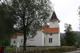
Netlandsnes Chapel is a parish church of the Church of Norway in Kvinesdal Municipality in Agder county, Norway. It is located in the village of Netland along the river Kvina, about 20 kilometres (12 mi) northwest of Fjotland. It is one of the two churches for the Fjotland parish which is part of the Lister og Mandal prosti (deanery) in the Diocese of Agder og Telemark. The white, wooden church was built in a long church design in 1886 using plans drawn up by the architect H.A. Fedde. The church seats about 100 people.

