
Cranston, once known as Pawtuxet, is a city in Providence County, Rhode Island, United States. The official population of the city is 80,559, making it the second largest in the state. The center of population of Rhode Island is located in Cranston. Cranston is a part of the Providence metropolitan area.
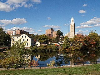
Pawtucket is a city in Providence County, Rhode Island, United States. The population was 71,148 at the 2010 census. It is the fourth largest city in the state.

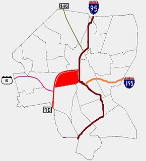
Olneyville is a neighborhood in Providence, Rhode Island bordered by Atwells Avenue to the north, U.S. Route 6 to the south and Rhode Island Route 10 to the east. The Woonasquatucket River runs through the southern portion of the neighborhood. The area is roughly triangular.

Thomas Alexander Tefft was an American architect, from Providence, Rhode Island.
The Federal Hill neighborhood has a salient role in the history of Providence due to its central location within the city. This part of Providence is best known for its Italian American community and abundance of Italian restaurants.
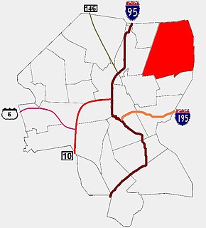
Blackstone is a predominantly residential neighborhood in Providence, Rhode Island. It is in the northeast corner of the city and is bounded to the south and west by Lloyd Avenue and Hope Street respectively. It is one of six neighborhoods comprising the East Side of Providence.

College Hill is a neighborhood in Providence, Rhode Island, and one of six neighborhoods comprising the East Side of Providence and part of the College Hill Historic District. It is roughly bounded by South and North Main Street to the west, Power Street to the south, Governor Street and Arlington Avenue to the east and Olney Street to the north. College Hill is also home to Thayer Street, a shopping strip frequented by students in the Providence area.

Fox Point is a neighborhood in the East Side of Providence, Rhode Island. It is bounded by the Providence and Seekonk rivers, Interstate 195 and the College Hill and Wayland neighborhoods. Fox Point is the southernmost neighborhood in the East Side area of Providence.

Charles is a neighborhood in northern Providence, Rhode Island. Along with Wanskuck, it comprises what is sometimes referred to as the North End. To the west Charles is partitioned from Wanskuck by Route 146, while the Chad Brown public housing complex separates Charles from Smith Hill to the south, and the West River and Interstate 95 bounds the area to the east. The city limits abutting the city of North Providence bound Charles to the north.

The West End is a neighborhood in the southwestern part of Providence, Rhode Island in the region often referred to as the South Side. Its boundaries are delineated by Westminster Street to the north, Huntington Avenue to the south, Elmwood Avenue to the east and the railroad tracks with Route 10 to the west. Cranston Street runs through the center of West End, past the Cranston Street Armory which has given the neighborhood the alternative name of the "Armory District."

The East Side is a collection of neighborhoods in the eastern part of the city of Providence, Rhode Island. It officially comprises the neighborhoods of Blackstone, Hope, Mount Hope, College Hill, Wayland, and Fox Point.

Elmhurst is a primarily residential neighborhood in the northwest quadrant of Providence, Rhode Island. Douglas Avenue and Admiral Street bound Elmhurst to the northeast, Academy Avenue and Smith Street bound it to the west, while Chalkstone Avenue marks the southern border.

Elmwood is a neighborhood in the South Side of Providence, Rhode Island. The triangular region is demarcated by Broad Street, Elmwood Avenue, and Interstate 95.

Silver Lake is a neighborhood on the western edge of Providence, Rhode Island. It is bordered by the Hartford neighborhood to the north, Route 10 to the east, Johnston and Cranston on the West and separated from Olneyville by Route 6.

Hartford is a neighborhood located along the western edge of Providence, Rhode Island. Route 6 and the Woonasquatucket River separates it from Olneyville.

Upper South Providence is an official neighborhood in the South Side in the city of Providence, Rhode Island. It is bound to the north by Interstate 95, the east by the Providence River, to the south by Public Street, and the west by Broad Street. Often associated with Lower South Providence directly to its south, Upper South Providence is a distinct neighborhood.

The South Side of Providence, Rhode Island, originally South Providence, is a term frequently used to describe the collective region comprising the official neighborhoods of Upper and Lower South Providence, Elmwood and the West End. The name was first used in the 1830s when the New York, Providence and Boston Railroad established its first station at a pier on the Providence River on a point of land about one half mile south of downtown Providence. The station was named South Providence.

Manton is a residential neighborhood in Providence, Rhode Island and part of Johnston, Rhode Island. It is in the westernmost part of the city. of Providence The town of North Providence borders it to the north, Johnston to the west, while the neighborhoods of Hartford, Olneyville, and Mount Pleasant border it inside Providence. Separating it from other Providence neighborhoods to its east are Rushmore Ave, Chalkstone Ave, Smith Street, and the Triggs Memorial Golf Course. The Woonasquatucket River separates it from Johnston to the west.

Providence is the capital and most populous city of the state of Rhode Island and is one of the oldest cities in the United States. It was founded in 1636 by Roger Williams, a Reformed Baptist theologian and religious exile from the Massachusetts Bay Colony. He named the area in honor of "God's merciful Providence" which he believed was responsible for revealing such a haven for him and his followers. The city is situated at the mouth of the Providence River at the head of Narragansett Bay.
The Miriam Hospital is a private, not-for-profit hospital at 164 Summit Avenue in Providence, in the U.S. state of Rhode Island. It is a major teaching affiliate of the Warren Alpert Medical School of Brown University.
