Upper South Providence, Providence, Rhode Island

Last updated
Providence neighborhoods with Upper South Providence in red Provneighuppersouth.JPG
Providence neighborhoods with Upper South Providence in red

Upper South Providence is an official neighborhood in the South Side in the city of Providence, Rhode Island. It is bound to the north by Interstate 95, the east by the Providence River, to the south by Public Street, and the west by Broad Street. Often associated with Lower South Providence directly to its south, Upper South Providence is a distinct neighborhood.

Contents

History

After the founding of Providence, the area that is today Upper South Providence Between 1754-1868, the neighborhood and areas south were part of the city of Cranston, Rhode Island. The area did not witness substantial development until the industrialization of the late 19th century, when it attracted Irish and Jewish immigrants. [1]

The Liston campus of Community College of Rhode Island was established in Upper South Providence in 1990 CCRI Liston Campus.jpg
The Liston campus of Community College of Rhode Island was established in Upper South Providence in 1990

The Pine/Friendship street area, in the northern section of South Providence, was the camping ground for Rochambeau's troops in June 1781, prior to the start of their march to Yorktown. [3] 1832 saw the beginning of middle and upper-class residential development here. [3] By the late 19th century, many impressive Greek Revival, Italianate, Queen Anne, and Second Empire homes were built; many of these have since been demolished. [3] The area was home to wealthy textile and jewelry magnates, including the president of the Gorham Manufacturing Company. [3]

By the early 20th century, transit improvements encouraged the more affluent residents to move to the outer ring of the city. [3]

In 1868, most of the area was reannexed by Providence from Cranston. [3] For the next 90 years, the area was predominantly Irish Catholic, with a significant Jewish minority. [3] Many Roman Catholic churches remain in the area today.

Government

At the municipal level, all of Upper South Providence [4] falls within Ward 11. [5] This ward is represented in the Providence City Council by Mary Kay Harris, a Democrat. [6]

Demographics

As of March 2007, 41.2% of residents in Upper South Providence were Hispanic, 34% were Black or African-American, 28.7% were White (18.8% Non-Hispanic White), 2.6% were Asian or Pacific Islander, and 2.6% were Native American. [7]

Nearly half of all public school children under the age of six speak a language other than English as their primary language. This is slightly below the citywide average of 54%. [7]

The Upper South Side continues to struggle with entrenched poverty. The median family income was $24,656 as of March 2007, well below the citywide average of $32,058. [7] As of the year 2000 census, the area's unemployment rate at 17% was the highest in the city, with 27% unemployment in the Upper South Side's largest block. [8] 36.4% of families live below the poverty line while 16% rely on some form of public assistance. One in four children in this neighborhood under the age of six have been exposed to high amounts of lead, primarily from lead paint in older homes. [7]

Parks and Greenspaces

Unlike other neighborhoods in Providence, Upper South Providence does not include many parks or green spaces. The largest green space in Upper South Providence is the Davey Lopes Recreation Center at the corner of Dudley Street and Prairie Avenue. Smaller parks include the Dudley Street Gateway and the Pearl Street Park. [9] Peace & Plenty Park is located at 98 Peace Street, in nearby Elmwood. This 10,000 sq ft. playground is one of the few playgrounds in the South Side of Providence.

Hospitals

Women & Infants Hospital of Rhode Island Women and Infants Hospital Providence RI.jpg
Women & Infants Hospital of Rhode Island

Rhode Island Hospital, Women & Infants Hospital of Rhode Island, and Hasbro Children's Hospital are located in close proximity to one another in Upper South Providence. [10] [11] Rhode Island Hospital has 719 beds and an acute care hospital and an academic center affiliated with Brown University's School of Medicine.

Related Research Articles

<span class="mw-page-title-main">Olneyville, Providence, Rhode Island</span> Neighborhood of Providence in Rhode Island, United States

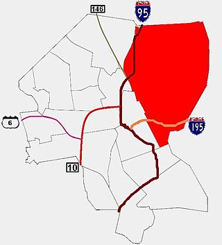
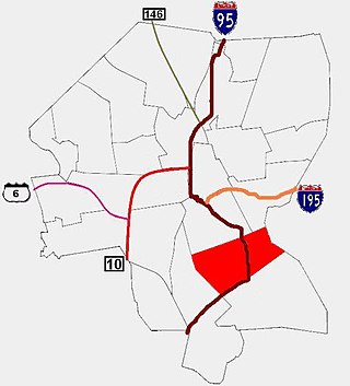
Olneyville is a neighborhood in Providence, Rhode Island bordered by Atwells Avenue to the north, U.S. Route 6 to the south and Rhode Island Route 10 to the east. The Woonasquatucket River runs through the southern portion of the neighborhood. The area is roughly triangular.

<span class="mw-page-title-main">Federal Hill, Providence, Rhode Island</span> Neighborhood of Providence in Providence County, Rhode Island, United States

Federal Hill is a neighborhood in Providence, Rhode Island. It lies immediately west of the city's Downtown, across Interstate 95. Since the late 19th century, Federal Hill has been an enclave of Providence's Italian American community; today the neighborhood is known as Providence's Little Italy and is noted for its abundance of Italian restaurants, markets, and cultural establishments.

<span class="mw-page-title-main">Smith Hill, Providence, Rhode Island</span> United States historic place

Smith Hill is a neighborhood in Providence, Rhode Island. Its traditional bounds are the Woonasquatucket River, the Chad Brown public housing complex, Interstate 95 and West River.

<span class="mw-page-title-main">Blackstone, Providence, Rhode Island</span>

Blackstone is a predominantly residential neighborhood in Providence, Rhode Island. It is in the northeast corner of the city and is bounded to the south and west by Lloyd Avenue and Hope Street respectively. It is one of six neighborhoods comprising the East Side of Providence.

<span class="mw-page-title-main">Fox Point, Providence, Rhode Island</span> Neighborhood of Providence in Rhode Island, United States

Fox Point is a neighborhood in the East Side of Providence, Rhode Island. It is bounded by the Providence and Seekonk rivers, Interstate 195 and the College Hill and Wayland neighborhoods. Fox Point is the southernmost neighborhood in the East Side area of Providence.

<span class="mw-page-title-main">Charles, Providence, Rhode Island</span>

Charles is a neighborhood in northern Providence, Rhode Island. Along with Wanskuck, it comprises what is sometimes referred to as the North End. To the west Charles is partitioned from Wanskuck by Route 146, while the Chad Brown public housing complex separates Charles from Smith Hill to the south, and the West River and Interstate 95 bounds the area to the east. The city limits abutting the city of North Providence bound Charles to the north.

<span class="mw-page-title-main">West End, Providence, Rhode Island</span> Neighborhood in the southwestern part of Providence, Rhode Island

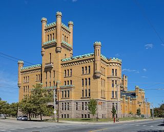
The West End is a neighborhood in the southwestern part of Providence, Rhode Island in the region often referred to as the South Side. Its boundaries are delineated by Westminster Street to the north, Huntington Avenue to the south, Elmwood Avenue to the east and the railroad tracks with Route 10 to the west. Cranston Street runs through the center of West End, past the Cranston Street Armory which has given the neighborhood the alternative name of the "Armory District."

<span class="mw-page-title-main">East Side, Providence, Rhode Island</span> Collection of neighborhoods

The East Side is a collection of neighborhoods in the eastern part of the city of Providence, Rhode Island. It officially comprises the neighborhoods of Blackstone, Hope, Mount Hope, College Hill, Wayland, and Fox Point.

<span class="mw-page-title-main">Elmhurst, Providence, Rhode Island</span>

Elmhurst is a primarily residential neighborhood in the northwest quadrant of Providence, Rhode Island. Douglas Avenue and Admiral Street bound Elmhurst to the northeast, Academy Avenue and Smith Street bound it to the west, while Chalkstone Avenue marks the southern border.

Elmwood is a neighborhood in the South Side of Providence, Rhode Island. The triangular region is demarcated by Broad Street, Elmwood Avenue, and Interstate 95.

<span class="mw-page-title-main">Silver Lake, Providence, Rhode Island</span>

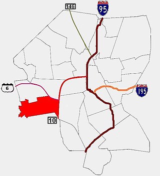
Silver Lake is a neighborhood on the western edge of Providence, Rhode Island. It is bordered by the Hartford neighborhood to the north, Route 10 to the east, Johnston and Cranston on the West and separated from Olneyville by Route 6.

<span class="mw-page-title-main">Hartford, Providence, Rhode Island</span> Neighborhood in Providence, Rhode Island

Hartford is a neighborhood located along the western edge of Providence, Rhode Island. Route 6 and the Woonasquatucket River separates it from Olneyville.

<span class="mw-page-title-main">South Side, Providence, Rhode Island</span>

The South Side of Providence, Rhode Island, originally South Providence, is a term frequently used to describe the collective region comprising the official neighborhoods of Upper and Lower South Providence, Elmwood and the West End. The name was first used in the 1830s when the New York, Providence and Boston Railroad established its first station at a pier on the Providence River on a point of land about one half mile south of downtown Providence. The station was named South Providence.

<span class="mw-page-title-main">Hope, Providence, Rhode Island</span>

Hope is a neighborhood on the northern border of Providence, Rhode Island. To the west, it is bounded by North Main Street, the North Burial Ground, and Interstate 95, while Rochambeau Ave, Hope Street, and the Providence-Pawtucket city line roughly delineate its boundaries to the south, east, and north respectively. Hope is sometimes referred to as "Summit", named for the street that runs through the middle of the neighborhood. Though "Hope" is officially recognized, residents and the local neighborhood organization more often use "Summit".

<span class="mw-page-title-main">Lower South Providence, Providence, Rhode Island</span>

The Lower South Side is a neighborhood in the southern part of Providence, Rhode Island. It is bounded by Public Street to the north, by Interstate 95 to the south, by Broad Street to the west, and by the Providence River to the east.

<span class="mw-page-title-main">Manton, Providence, Rhode Island</span> Residential neighborhood

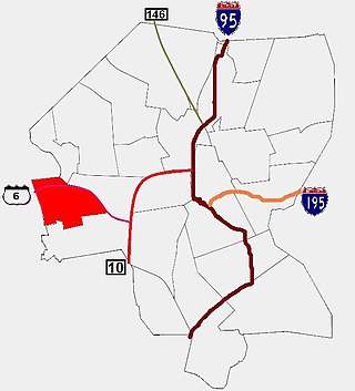
Manton is a residential neighborhood in Providence, Rhode Island and part of Johnston, Rhode Island. It is in the westernmost part of the city. of Providence The town of North Providence borders it to the north, Johnston to the west, while the neighborhoods of Hartford, Olneyville, and Mount Pleasant border it inside Providence. Separating it from other Providence neighborhoods to its east are Rushmore Ave, Chalkstone Ave, Smith Street, and the Triggs Memorial Golf Course. The Woonasquatucket River separates it from Johnston to the west.

<span class="mw-page-title-main">Mount Pleasant, Providence, Rhode Island</span>

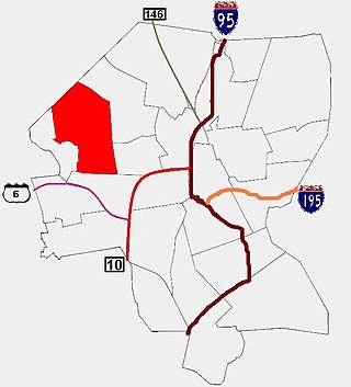
Mount Pleasant is a working-class residential neighborhood situated in the northwest of the city of Providence, Rhode Island. It is bordered by Olneyville to the south, Valley to the east, Manton to the west, and Elmhurst to the northeast, and the Town of North Providence to the north. The major street boundaries that define Mount Pleasant are Academy Avenue to the east, Smith Street to the northeast, Atwells Avenue to the south, and portions of Bullock, Chalkstone, Mera, and Rushmore Avenues to the west.

<span class="mw-page-title-main">Reservoir, Providence, Rhode Island</span>

Reservoir is a neighborhood in southwest Providence, Rhode Island. It is bounded to the north and east by the Amtrak Northeast Corridor railroad tracks, and to the west and south by the municipal boundary with Cranston. The population of the neighborhood, as of 2000, was 2,963.

<span class="mw-page-title-main">South Elmwood, Providence, Rhode Island</span>

South Elmwood is the southernmost neighborhood in Providence, Rhode Island, and is home to Roger Williams Park and the Roger Williams Park Zoo. The neighborhood is bounded to the northwest by Interstate 95, to the northeast by Broad Street and Verndale Avenue, and on all other sides by the municipal boundary with Cranston. The population of the neighborhood, as of 2000, was 2,184.

<span class="mw-page-title-main">Washington Park, Providence, Rhode Island</span> Neighborhood of Providence in Rhode Island, United States

Washington Park is a neighborhood in Providence, Rhode Island. The neighborhood occupies the southeastern portion of the city along the Providence River.

References

  1. Providence Neighborhoods: Upper South Providence
  2. "Our History". Community College of Rhode Island. Retrieved 14 April 2021.
  3. 1 2 3 4 5 6 7 Conley, Patrick T. (2006). South Providence. Arcadia Publishing. pp. 7–8. ISBN   9780738544847 . Retrieved 13 June 2020.
  4. "Upper South Providence". Archived from the original on 2016-04-09. Retrieved 2017-02-16.
  5. "Ward 11 map" (PDF). Archived from the original (PDF) on 2015-10-18. Retrieved 2024-01-25.
  6. Providence City Council Ward 11- Phone: (401) 521-7477
  7. 1 2 3 4 Upper South Providence
  8. Unemployment by Neighborhood
  9. Citywide Green
  10. Rhode Island Hospital
  11. Women & Infants Hospital : Providence, Rhode Island

Neighborhood Profiles at providenceri.com

41°48′44″N71°24′33″W / 41.8122°N 71.4091°W / 41.8122; -71.4091