Washington Park | |
|---|---|
 Johnson & Wales' Harborside campus | |
| Country | |
| State | |
| City | Providence |
Washington Park is a neighborhood in Providence, Rhode Island. The neighborhood occupies the southeastern portion of the city along the Providence River.
Washington Park | |
|---|---|
| Johnson & Wales' Harborside campus | |
| Country | |
| State | |
| City | Providence |
Washington Park is a neighborhood in Providence, Rhode Island. The neighborhood occupies the southeastern portion of the city along the Providence River.
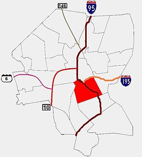
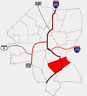
Washington Park is bounded to the north by Route 95 and continues south to the Cranston city line. On the west, it starts at the edge of Roger Williams Park and spreads east to the waterfront. [1]
Washington Park contains Fields Point, home to Save the Bay. It also includes the Port of Providence and the Harborside Campus of Johnson & Wales University. Much of the area is residential along the side streets off Broad Street and Narragansett Boulevard. [1]

In the 1600s, most of the area was owned by Roger Williams and later by his descendants. [1] In the 1870s, Betsy Williams offered the farm to the city as a park. [1]
Washington Park gets its name from a horse racing track built by Edward Babcock and his son William in the mid-1800s (and stood until at least 1884), on farmland between the water and Broad Street. [1] [2] Houses started being built in the area in the late 1800s through the 1940s. [1] After World War I and World War II, industrial development grew along the waterfront, which increased demand for housing. [1]
On May 14, 2021, eight people were shot and wounded and a ninth victim was wounded from glass shards in vicinity of the park. The shooting was believed by authorities to have stemmed from conflict between two rival groups. It was the largest number of victims of any shooting in Providence's history. [3] [4]

Chelsea is a city in Suffolk County, Massachusetts, United States, directly across the Mystic River from the city of Boston. As of the 2020 census, Chelsea had a population of 40,787. With a total area of just 2.46 square miles, Chelsea is the smallest city in Massachusetts in terms of total area. It is the second most densely populated city in Massachusetts, behind Somerville, and is the city with the second-highest percentage of Latino residents in Massachusetts, behind Lawrence.

Canton is a historic waterfront neighborhood in Baltimore, Maryland, United States. The neighborhood is along Baltimore's outer harbor in the southeastern section of the city, roughly two miles east of Baltimore's downtown district and next to or near the neighborhoods of Patterson Park, Fell's Point, Highlandtown, and Brewers Hill.

Boston's diverse neighborhoods serve as a political and cultural organizing mechanism. The City of Boston's Office of Neighborhood Services has designated 23 Neighborhoods in the city:

Bay Village is the smallest officially recognized neighborhood of Boston, Massachusetts. As of 2010, its population was approximately 1,312 residents living in 837 housing units, most of which are small brick rowhouses.

Federal Hill is a neighborhood in Providence, Rhode Island. It lies immediately west of the city's Downtown, across Interstate 95. Since the late 19th century, Federal Hill has been an enclave of Providence's Italian American community; today the neighborhood is known as Providence's Little Italy and is noted for its abundance of Italian restaurants, markets, and cultural establishments.

Smith Hill is a neighborhood in Providence, Rhode Island. Its traditional bounds are the Woonasquatucket River, the Chad Brown public housing complex, Interstate 95 and West River.

The Southwest Waterfront is a mostly residential neighborhood in Southwest Washington, D.C. The Southwest quadrant is the smallest of Washington's four quadrants, and the Southwest Waterfront is one of only two residential neighborhoods in the quadrant; the other is Bellevue, which, being east of the Anacostia River, is frequently, if mistakenly, regarded as being in Southeast. For that reason, many residents of Southwest Waterfront will refer to themselves as living in "Southwest."

College Hill is a historic neighborhood of Providence, Rhode Island, and one of six neighborhoods comprising the city's East Side. It is roughly bounded by South and North Main Street to the west, Power Street to the south, Governor Street and Arlington Avenue to the east and Olney Street to the north. The neighborhood's primary commercial area extends along Thayer Street, a strip frequented by students in the Providence area.

Fox Point is a neighborhood in the East Side of Providence, Rhode Island. It is bounded by the Providence and Seekonk rivers, Interstate 195 and the College Hill and Wayland neighborhoods. Fox Point is the southernmost neighborhood in the East Side area of Providence.

The East Side is a collection of neighborhoods in the eastern part of the city of Providence, Rhode Island. It officially comprises the neighborhoods of Blackstone, Hope, Mount Hope, College Hill, Wayland, and Fox Point.

Elmhurst is a primarily residential neighborhood in the northwest quadrant of Providence, Rhode Island. Douglas Avenue and Admiral Street bound Elmhurst to the northeast, Academy Avenue and Smith Street bound it to the west, while Chalkstone Avenue marks the southern border.
Elmwood is a neighborhood in the South Side of Providence, Rhode Island. The triangular region is demarcated by Broad Street, Elmwood Avenue, and Interstate 95.
Upper South Providence is an official neighborhood in the South Side in the city of Providence, Rhode Island. It is bound to the north by Interstate 95, the east by the Providence River, to the south by Public Street, and the west by Broad Street. Often associated with Lower South Providence directly to its south, Upper South Providence is a distinct neighborhood.
The Lower South Side is a neighborhood in the southern part of Providence, Rhode Island. It is bounded by Public Street to the north, by Interstate 95 to the south, by Broad Street to the west, and by the Providence River to the east.

The Roger Williams Medical Center (RWMC) is a university-affiliated teaching hospital in Providence, Rhode Island. Roger Williams Medical Center has an affiliation with Boston University School of Medicine. The Roger Williams Medical Center (RWMC), located in the Elmhurst section of Providence, has served the community's health care needs since 1922. Along with corporate parent CharterCARE Health Partners and as a major teaching affiliate of Boston University School of Medicine (BUSM), this academic medical center has sustained fully accredited ACGME teaching programs for more than 40 years.
Providence is the capital and most populous city of the U.S. state of Rhode Island. One of the oldest cities in the United States, it was founded in 1636 by Roger Williams, a Reformed Baptist theologian and religious exile from the Massachusetts Bay Colony. He named the area in honor of "God's merciful Providence" which he believed was responsible for revealing such a haven for him and his followers. The city is situated at the mouth of the Providence River at the head of Narragansett Bay.

Hard Scrabble and Snow Town were two African American neighborhoods located in Providence, Rhode Island in the nineteenth century. They were also the sites of race riots in which working-class whites destroyed multiple black homes in 1824 and 1831, respectively.

South Elmwood is the southernmost neighborhood in Providence, Rhode Island, and is home to Roger Williams Park and the Roger Williams Park Zoo. The neighborhood is bounded to the northwest by Interstate 95, to the northeast by Broad Street and Verndale Avenue, and on all other sides by the municipal boundary with Cranston. The population of the neighborhood, as of 2000, was 2,184.
The following is a timeline of the history of the city of Providence, Rhode Island, United States.
The Seaport District, or simply the Seaport, is a neighborhood in Boston, Massachusetts. It is part of the larger neighborhood of South Boston, and is also sometimes called the Innovation District. The Seaport is a formerly industrial area that has undergone an extensive redevelopment effort in recent years. It is bordered by the Fort Point Channel to the west, Boston Harbor to the north and east, and the historic residential neighborhood of South Boston to the south. It is officially referred to by the City of Boston as The South Boston Waterfront. The Seaport District is at extreme risk of climate-related flooding over the next 30 years.
Coordinates: 41°47′38″N71°23′33″W / 41.793886°N 71.392389°W
| | This Rhode Island state location article is a stub. You can help Wikipedia by expanding it. |