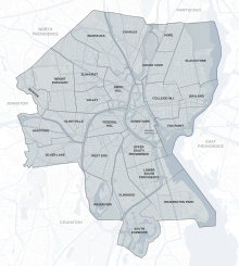
The city of Providence, Rhode Island has 25 official neighborhoods. [1]
The city of Providence, Rhode Island has 25 official neighborhoods. [1]
Many of these neighborhoods are often grouped together referred to collectively:

The Jewelry District occupies the southern portion of Downtown Providence. Since the area was re-united with Downtown following the relocation of Interstate 195, the city has been working to attract high-tech and research companies to this area under the rebranded name of "Knowledge District." [4] This area is not recognized as one of Providence's 25 official neighborhoods. [3] [5] The Hospital District, a non-residential area within Upper South Providence is similarly unrecognized.
The oldest, highest density neighborhoods are either those close to Downtown or proximate to the Woonasquatucket River, which provided a power source for early industrialization in Manton, Hartford, and Olneyville. More distant neighborhoods developed later, mostly as transportation as public horse car and streetcar lines were added.


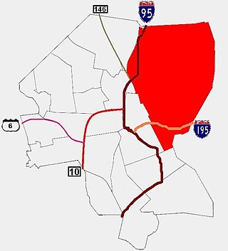
Route 10 is a numbered state highway connector in the U.S. state of Rhode Island, traveling along the Huntington Expressway, the first freeway in the state. It connects Route 12 on the Cranston–Providence city line with Interstate 95 (I-95), U.S. Route 6 (US 6), and Memorial Boulevard in downtown Providence, passing just east of the Olneyville area of Providence. It provides an alternate route to I-95 south of downtown, and connects it with the US 6 freeway west from Olneyville towards I-295 and Connecticut.

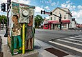
Olneyville is a neighborhood in Providence, Rhode Island bordered by Atwells Avenue to the north, U.S. Route 6 to the south and Rhode Island Route 10 to the east. The Woonasquatucket River runs through the southern portion of the neighborhood. The area is roughly triangular.

The Woonasquatucket River is a river in the U.S. state of Rhode Island. It flows approximately 15.8 miles (25.4 km) and drains a watershed of 130 km2 (50 sq mi).
John J. Lombardi is an American Democratic politician from Providence, Rhode Island. As President of the Providence City Council, he served as acting mayor for four months between the conviction of Buddy Cianci and the election of David Cicilline.

Blackstone is a predominantly residential neighborhood in Providence, Rhode Island. It is in the northeast corner of the city and is bounded to the south and west by Lloyd Avenue and Hope Street respectively. It is one of six neighborhoods comprising the East Side of Providence.
The East Side is a collection of neighborhoods in the eastern part of the city of Providence, Rhode Island. It officially comprises the neighborhoods of Blackstone, Hope, Mount Hope, College Hill, Wayland, and Fox Point.

Elmwood is a neighborhood in the South Side of Providence, Rhode Island. The triangular region is demarcated by Broad Street, Elmwood Avenue, and Interstate 95.

Downtown is the central economic, political, and cultural district of the city of Providence, Rhode Island, United States. It is bounded on the east by Canal Street and the Providence River, to the north by Smith Street, to the west by Interstate 95, and to the south by Henderson Street. The highway serves as a physical barrier between the city's commercial core and neighborhoods of Federal Hill, West End, and Upper South Providence. Most of the downtown is listed on the National Register of Historic Places as the Downtown Providence Historic District.

The South Side of Providence, Rhode Island, originally South Providence, is a term frequently used to describe the collective region comprising the official neighborhoods of Upper and Lower South Providence, Elmwood and the West End. The name was first used in the 1830s when the New York, Providence and Boston Railroad established its first station at a pier on the Providence River on a point of land about one half mile south of downtown Providence. The station was named South Providence.

Manton is a residential neighborhood in Providence, Rhode Island and part of Johnston, Rhode Island. It is in the westernmost part of the city. of Providence The town of North Providence borders it to the north, Johnston to the west, while the neighborhoods of Hartford, Olneyville, and Mount Pleasant border it inside Providence. Separating it from other Providence neighborhoods to its east are Rushmore Ave, Chalkstone Ave, Smith Street, and the Triggs Memorial Golf Course. The Woonasquatucket River separates it from Johnston to the west.

The Rochambeau Library— A Community Library of Providence is an historic public library building at 708 Hope Street in Providence, Rhode Island. It was originally a single-story brick structure with limestone trim, designed by Wallis E. Howe and built in 1930. It has a symmetrical main facade, with the entrance in the center, sheltered by a porch supported by fluted Corinthian columns. The flanking bays are pavilions with gable fronts. A modern two-level addition with a glass front has been made to the north side of the building.
The Smith Hill Library-A Community Library of Providence is one of the branch libraries of the Providence, Rhode Island, public library system. It is located at 31 Candace Street, in a single-story brick building designed by Albert Harkness and built in 1932 by contractor Clifford K. Rathbone. Stylistically the building is a mixture of Colonial Revival and Moderne features. The Smith Hill branch began as a delivery station in 1907, and had grown to occupy leased space, with an annual circulation of more than 70,000, by 1929. Circulation rose rapidly after the building's completion, reaching 119,000 in just three years. The building continues to act as a significant local community resource.

South Providence Library—A Community Library of Providence is an historic branch library building at 441 Prairie Avenue in Providence, Rhode Island. The main portion of the building is a single-story brick Colonial Revival structure, designed by Wallis Howe and built in 1930. Due to the constraints of the lot, Howe's otherwise standard design was altered to place the building gable-end to the street. The street-facing facade has been obscured by a two-level glass-faced modern addition.

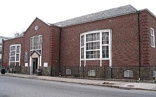
The Wanskuck Library—A Community Library of Providence is an historic branch library building at 233 Veazie Street in Providence, Rhode Island. It is a single-story brick and stone structure, built in 1928, replacing an earlier library building which had originally housed a library established by the Wanskuck Mill Company for its employees. The building was designed by Clarke & Howe, and is an excellent local example of Colonial Revival design, with a tetrastyle entrance portico. It was the first of ten libraries built based on Howe designs.

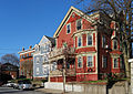
Providence is the capital and most populous city of the U.S. state of Rhode Island. The county seat of Providence County, it is one of the oldest cities in New England, founded in 1636 by Roger Williams, a Reformed Baptist theologian and religious exile from the Massachusetts Bay Colony. He named the area in honor of "God's merciful Providence" which he believed was responsible for revealing such a haven for him and his followers. The city developed as a busy port, as it is situated at the mouth of the Providence River at the head of Narragansett Bay.
Mount Pleasant is a working-class residential neighborhood situated in the northwest of the city of Providence, Rhode Island. It is bordered by Olneyville to the south, Valley to the east, Manton to the west, and Elmhurst to the northeast, and the Town of North Providence to the north. The major street boundaries that define Mount Pleasant are Academy Avenue to the east, Smith Street to the northeast, Atwells Avenue to the south, and portions of Bullock, Chalkstone, Mera, and Rushmore Avenues to the west.

Clifton A. Hall (1826-1913) was an American architect from Providence, Rhode Island.
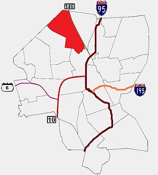
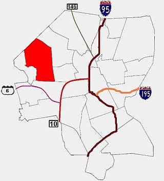
Wanskuck is a neighborhood in the northern part of Providence, Rhode Island. Along with Charles, it is one of two neighborhoods comprising what is often referred to as the North End. Wanskuck is bounded to the east by Route 146, to the west by Providence College, Admiral Street, Route 7, and Huxley Avenue, and to the south roughly by Fillmore Street. Parts of Wanskuck north of Branch Avenue are the Wanskuck Historic District.
Jackson, Robertson & Adams was an architectural firm out of Providence, Rhode Island. Established in 1912, it was originally made up of architects F. Ellis Jackson (1879–1950), Wayland T. Robertson (1873–1935), and J. Howard Adams (1876–1924).