Sumter County is a county located in the central portion of the U.S. state of Florida. As of the 2010 census, the population is 93,420. It has the oldest median age of any US county and the highest percentage of residents aged 65 and older—at 55.6% in 2014-2018. Its county seat is Bushnell, and the largest community is The Villages.

Sumter County is a county located in the west central portion of Alabama. At the 2010 census, the population was 13,763. Its county seat is Livingston. Its name is in honor of General Thomas Sumter of South Carolina.

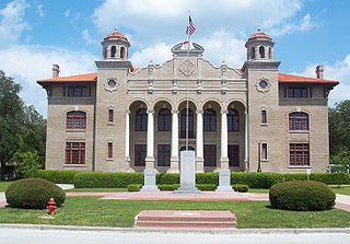
Sumter County is a county located in the U.S. state of South Carolina. As of the 2010 census, the population was 107,456. In a 2018 census estimate, the population was 106,512. Its county seat is Sumter.

Lenoir County is a county in the U.S. state of North Carolina. As of the 2010 Census, the population was 59,495. Its county seat is Kinston, located on the Neuse River, across which the county has its territory.

Blythewood is a suburb of Columbia, South Carolina, in Richland and Fairfield counties, South Carolina. 2020 estimates put the population at 4,446 up from 2,034 in 2010. Since 2000 it has had a population boom, going from 170 people in 2000 to a population of 2,034 in 2010, representing an increase of 1096%. It is part of the Columbia, South Carolina, Metropolitan Statistical Area. It is located around 15 miles from downtown Columbia.
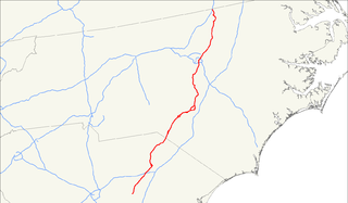
U.S. Route 401 (US 401) is a north–south United States highway, a spur of U.S. Route 1, that travels along the Fall Line from Sumter, South Carolina to Interstate 85 near Wise, North Carolina.

The Broad River is a principal tributary of the Congaree River, about 150 miles (240 km) long, in western North Carolina and northern South Carolina in the United States. Via the Congaree, it is part of the watershed of the Santee River, which flows to the Atlantic Ocean.

The 5th congressional district of South Carolina is a congressional district in northern South Carolina bordering North Carolina. The district includes all of Cherokee, Chester, Fairfield, Kershaw, Lancaster, Lee, Union and York counties and parts of Newberry, Spartanburg and Sumter counties. Outside the rapidly growing cities of Rock Hill, Fort Mill, and Lake Wylie the district is mostly rural and agricultural. The district borders were contracted from some of the easternmost counties in the 2012 redistricting.

The University of South Carolina Sumter is a public college in Sumter, South Carolina. It is part of the University of South Carolina System and one of the four regional USC campuses which make up Palmetto College. It only awards associate degrees and has approximately 1,500 students. It is accredited by the Commission on Colleges of the Southern Association of Colleges and Schools.

The Stateburg Historic District is a historic district in Stateburg, in the High Hills of Santee area near Sumter, South Carolina in the United States. It includes two National Historic Landmarks, Borough House Plantation and the Church of the Holy Cross, and at least eight contributing properties within its boundaries. On February 24, 1971, it was added to the National Register of Historic Places. The historic district extends north and east of the town of Stateburg as far north as Meeting House Road and as far east as South Carolina Highway 441, covering an area of 5,066 acres (20.50 km2).
Wedgefield is an unincorporated community in the High Hills of Santee area in western Sumter County, South Carolina, United States. Wedgefield is also a Census Designated Place (CDP). Wedgefield was so named because its location was likened to a "wedge" into the High Hills of Santee. In the 18th and 19th centuries it was the location of many plantations, notably those of the Singleton family, which produced First Lady of the United States, Angelica Singleton Van Buren. Today the plantations are gone except for their cemeteries and Wedgefield is today noted as the location of a state park, a state forest and other recreational places. When the railroad came through in the 19th century, the commercial center of Wedgefield developed at the intersection of the railroad, Kings Highway and Wedgefield Road. It has its own post office with the Zip Code of 29168.
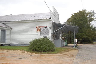
The Lenoir Store built in 1869 is an historic general store building located in the High Hills of Santee community of Horatio, South Carolina. It stands on the same site where the Lenoir family has operated a general store since before 1808 and "is the oldest business establishment in Sumter County". Since 1900 it has served as the post office for Horatio Zip Code 29062. On July 3, 1997, it was added to the National Register of Historic Places. As of that date, it was still being operated by members of the Lenoir family. Lenoir is pronounced le-nore or len-wa by some of its more northern members.
Hagood is an unincorporated community in the High Hills of Santee area in western Sumter County, South Carolina, United States. It lies west of South Carolina Highway 261, north of Stateburg and is the location of Magnolia Hall, which is listed on the National Register of Historic Places. Its mail now comes from Rembert zip code 29128. The community was originally called Sander's Station by the South Carolina Railway, apparently for Dr. Swepson Saunders, the owner of Magnolia Hall plantation, on which it was located, but was renamed Hagood for Johnson Hagood, brigadier general in the Confederate States Army and later governor of South Carolina.
The High Hills of Santee, sometimes known as the High Hills of the Santee, is a long, narrow hilly region in the western part of Sumter County, South Carolina. It has been called "one of the state's most famous areas". The High Hills of Santee region lies north of the Santee River and east of the Wateree River, one of the two rivers that join to form the Santee. It extends north almost to the Kershaw county line and northeasterly to include the former summer resort town of Bradford Springs. Since 1902 the town has been included in Lee County.
Salem County was a former county in east central of South Carolina. It was created in 1791 from Claremont and Clarendon counties and lasted until it was absorbed into the newly created Sumter District in 1800.
Claremont County was a county in east central South Carolina. Its county seat was Stateburg. It lasted from its creation in 1785, when it was created from the Camden District, until it was absorbed into the newly created Sumter District in 1800.
Sumter High School is a co-educational four-year public high school serving grades 9 through 12 in Sumter School District located in the south side of Sumter, South Carolina, United States. With an enrollment of approximately 2,300 students, Sumter High is the second-largest high school in the Midlands of South Carolina and the fifth largest in the state of South Carolina. In 2004 Sumter High School was designated The Model School for SC and one of thirty model schools nationwide by a national organization funded by the Bill and Melinda Gates Foundation.
North Carolina Highway 241 (NC 241) is a primary state highway in the U.S. state of North Carolina. NC 241 travels for 9.1 miles (14.6 km) from NC 41/NC 111 in Beulaville to NC 11 in Pink Hill. Outside of Beulaville and Pink Hill, NC 241 is a rather straight, predomiantly rural route. The highway travels through Duplin County for 7.6 miles (12.2 km) while traveling 1.5 miles (2.4 km) in Lenoir County.
South Carolina Highway 441 (SC 441) is a 26.280-mile-long (42.294 km) state highway in the U.S. state of South Carolina. The highway connects the Sumter area in Sumter County with rural areas of Lee County.
Claremont is an unincorporated community in Sumter County, in the U.S. state of South Carolina.

