Sumter County is a county located in the U.S. state of South Carolina. As of the 2020 census, the population was 105,556. In a 2018 census estimate, the population was 106,512. Its county seat is Sumter.
Stateburg is a census-designated place (CDP) in the High Hills of Santee in Sumter County, South Carolina, United States. The population was 1,380 at the 2010 census. It is included in the Sumter, South Carolina Metropolitan Statistical Area. Stateburg is located within the larger Stateburg Historic District.

Sumter is a city in and the county seat of Sumter County, South Carolina, United States. Known as the Sumter Metropolitan Statistical Area, the namesake county adjoins Clarendon and Lee to form the core of Sumter-Lee-Clarendon Tri-county area of South Carolina that includes three counties straddling the border of the Sandhills, Pee Dee, and Lowcountry regions. The population was 43,463 at the 2020 census.

Sarah Angelica Van Buren, was the daughter-in-law of the eighth president of the United States, Martin Van Buren. She was married to the President's son, Abraham Van Buren II. She assumed the post of first lady because the president's wife, Hannah Van Buren, had died and he never remarried. She is the youngest woman ever to act as the White House hostess.

U.S. Route 521 (US 521) is a north–south United States Highway that traverses 177.3 miles (285.3 km), from Georgetown, South Carolina, to Charlotte, North Carolina. Though numbered as an auxiliary route of US 21, it does not actually intersect its parent or any of its sibling routes, though it is in the same general part of the country as other routes from its family. Historically, it once connected to US 21 in Pineville, North Carolina, but various changes have left it terminating a few miles short of the current US 21.

U.S. Route 378 (US 378) is a spur of US 78 in the U.S. states of Georgia and South Carolina. The U.S. Highway runs 234.30 miles (377.07 km) from US 78, Georgia State Route 10 (SR 10), SR 17, and SR 47 in Washington, Georgia, east to US 501 Business in Conway, South Carolina. US 378 connects the Central Savannah River Area in both states with the Midlands and Pee Dee regions of South Carolina. The U.S. Highway's western portion, which connects Washington and Lincolnton in Georgia and McCormick, Saluda, and Lexington in South Carolina, is mainly a rural highway. US 378 is a major suburban and urban highway through Lexington and South Carolina's state capital, Columbia. The highway has a lengthy concurrency with US 76 between Columbia and Sumter and serves as a major route between the Midlands and the Myrtle Beach area, between which the highway has a business route through Lake City.

Interstate 95 (I-95) is a major Interstate Highway, running along the East Coast of the United States from Florida to Maine. In South Carolina, I-95 runs approximately parallel to the Atlantic Ocean shore although about 50 miles (80 km) inland, from Hardeeville in the south to Dillon in the northeast. The route runs through the cities of Florence and Walterboro.

Borough House Plantation, also known as Borough House, Hillcrest Plantation and Anderson Place, is an historic plantation on South Carolina Highway 261, 0.8 miles (1.3 km) north of its intersection with U.S. Route 76/US Route 378 in Stateburg, in the High Hills of Santee near Sumter, South Carolina. A National Historic Landmark, the plantation is noted as the largest assemblage of high-style pisé structures in the United States. The main house and six buildings on the plantation were built using this technique, beginning in 1821. The plantation is also notable as the home of Confederate Army General Richard H. Anderson.

South Carolina Highway 261 (SC 261) is a 116.960-mile (188.229 km) state highway in the U.S. state of South Carolina. It travels between Yauhannah in Georgetown County to Kershaw County. Although the highway covers more east–west distance, it is signed north–south.

The Stateburg Historic District is a historic district in Stateburg, in the High Hills of Santee area near Sumter, South Carolina in the United States. It includes two National Historic Landmarks, Borough House Plantation and the Church of the Holy Cross, and at least eight contributing properties within its boundaries. On February 24, 1971, it was added to the National Register of Historic Places. The historic district extends north and east of the town of Stateburg as far north as Meeting House Road and as far east as South Carolina Highway 441, covering an area of 5,066 acres (20.50 km2).
Singleton's Graveyard is an historic plantation cemetery located off SC 261 in the High Hills of Santee, 6 miles south of Wedgefield, South Carolina. On May 13, 1976, it was added to the National Register of Historic Places.
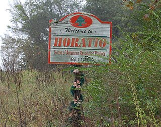
Horatio is an unincorporated community in the High Hills of Santee area in western Sumter County, South Carolina, United States.
Hagood is an unincorporated community in the High Hills of Santee area in western Sumter County, South Carolina, United States. It lies west of South Carolina Highway 261, north of Stateburg and is the location of Magnolia Hall, which is listed on the National Register of Historic Places. Its mail now comes from Rembert zip code 29128. The community was originally called Sander's Station by the South Carolina Railway, apparently for Dr. Swepson Saunders, the owner of Magnolia Hall plantation, on which it was located, but was renamed Hagood for Johnson Hagood, brigadier general in the Confederate States Army and later governor of South Carolina.
The High Hills of Santee, sometimes known as the High Hills of the Santee, is a long, narrow hilly region in the western part of Sumter County, South Carolina. It has been called "one of the state's most famous areas". The High Hills of Santee region lies north of the Santee River and east of the Wateree River, one of the two rivers that join to form the Santee. It extends north almost to the Kershaw county line and northeasterly to include the former summer resort town of Bradford Springs. Since 1902 the town has been included in Lee County.

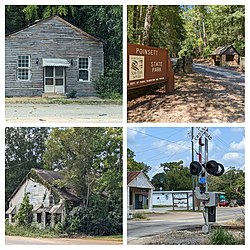
Poinsett State Park is located in Sumter County in the U.S. state of South Carolina. The park is best known for its botanical oddities, combining the flora of the Blue Ridge Mountains foothills and Piedmont of Upstate South Carolina, the xeric Sandhills and the Atlantic coastal plain. In Poinsett State Park one can see mountain laurels draped with Spanish moss. The park, which has been called "weird and beautiful", is named after amateur botanist and South Carolina native Joel Roberts Poinsett, the first American ambassador to Mexico and popularizer of the poinsettia. There is a $3 charge for admission to Poinsett State Park and there are small fees for overnight camping and cabin rentals. The park is surrounded by the Manchester State Forest, and both provide access to the Palmetto Trail, linked hiking and mountain bike trails, and Manchester State Forest offers equestrian trails.

South Carolina Highway 120 (SC 120) is a 17.390-mile (27.986 km) state highway in the U.S. state of South Carolina. The highway connects Pinewood and Sumter.
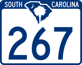
South Carolina Highway 267 (SC 267) is a 23.200-mile-long (37.337 km) state highway in the U.S. state of South Carolina. The highway connects the Santee area with rural areas of Orangeburg and Calhoun counties, via Elloree.

South Carolina Highway 441 (SC 441) is a 26.280-mile-long (42.294 km) state highway in the U.S. state of South Carolina. The highway connects the Sumter area in Sumter County with rural areas of Lee County.

South Carolina Highway 763 (SC 763) is a 13.950-mile-long (22.450 km) state highway in the U.S. state of South Carolina. The highway connects Wedgefield and Sumter, via Cane Savannah and Millwood.

South Carolina Highway 81 (SC 81) is a 80.890-mile-long (130.180 km) state highway in the U.S. state of South Carolina. The highway connects rural areas of McCormick County with Greenville, via Calhoun Falls, Iva, Homeland Park, and Anderson.