Oswego, South Carolina

Last updated

Oswego, South Carolina
CDP
USA South Carolina location map.svg
Red pog.svg
Oswego, South Carolina
Location within the state of South Carolina
Coordinates: 34°0′30″N80°17′14″W / 34.00833°N 80.28722°W / 34.00833; -80.28722
Country United States
State South Carolina
County Sumter
Area
[1]
  Total1.21 sq mi (3.12 km2)
  Land1.21 sq mi (3.12 km2)
  Water0.00 sq mi (0.00 km2)
Elevation
154 ft (47 m)
Population
 (2020) [2]
  Total86
  Density71.37/sq mi (27.55/km2)
Time zone UTC-5 (Eastern (EST))
  Summer (DST) UTC-4 (EDT)
ZIP code
29150
Area code(s) 803, 839
FIPS code 45-53485 [3]
GNIS feature ID1231619 [4]

Oswego is a census-designated place (CDP) in Sumter County, South Carolina, United States. The population was 95 at the 2000 census. It is included in the Sumter, South Carolina Metropolitan Statistical Area.

Contents

Geography

Oswego is located at 34°0′30″N80°17′14″W / 34.00833°N 80.28722°W / 34.00833; -80.28722 (34.008444, -80.287256). [5]

According to the United States Census Bureau, the CDP has a total area of 1.6 square miles (4.3 km2), all land.

Demographics

Historical population
CensusPop.Note
2020 86
U.S. Decennial Census [6]

As of the census [3] of 2000, there were 95 people, 42 households, and 34 families residing in the CDP. The population density was 57.7 inhabitants per square mile (22.3/km2). There were 42 housing units at an average density of 25.5/sq mi (9.8/km2). The racial makeup of the CDP was 89.47% White, 9.47% African American and 1.05% Native American.

There were 42 households, out of which 23.8% had children under the age of 18 living with them, 73.8% were married couples living together, 7.1% had a female householder with no husband present, and 16.7% were non-families. 14.3% of all households were made up of individuals, and 11.9% had someone living alone who was 65 years of age or older. The average household size was 2.26 and the average family size was 2.49.

In the CDP, the population was spread out, with 16.8% under the age of 18, 2.1% from 18 to 24, 18.9% from 25 to 44, 32.6% from 45 to 64, and 29.5% who were 65 years of age or older. The median age was 52 years. For every 100 females, there were 82.7 males. For every 100 females age 18 and over, there were 88.1 males.

The median income for a household in the CDP was $50,714, and the median income for a family was $52,500. Males had a median income of $38,750 versus $25,417 for females. The per capita income for the CDP was $23,379. None of the population and none of the families were below the poverty line.

Related Research Articles

<span class="mw-page-title-main">Boulder Hill, Illinois</span> Census-Designated Place in Illinois, United States

Boulder Hill is a census-designated place (CDP) in Oswego Township, Kendall County, Illinois, United States. Per the 2020 census, the population was 8,394. It is part of the Chicago metropolitan area on the Fox River, south of Aurora.

<span class="mw-page-title-main">Pigeon Creek, Ohio</span> CDP in Ohio, United States

Pigeon Creek is a census-designated place (CDP) in Summit County, Ohio, United States. The population was 945 at the 2000 census. It is part of the Akron metropolitan statistical area.

<span class="mw-page-title-main">West Hill, Ohio</span> Census-designated place in Ohio, United States

West Hill is an unincorporated community and census-designated place in eastern Brookfield Township, Trumbull County, Ohio, United States. The population was 2,218 at the 2020 census. It is part of the Youngstown–Warren metropolitan area.

<span class="mw-page-title-main">Carnot-Moon, Pennsylvania</span> Census-designated place in Pennsylvania, United States

Carnot-Moon is a census-designated place (CDP) in central Moon Township, Allegheny County, Pennsylvania, United States. The population was 13,151 at the 2020 census.

<span class="mw-page-title-main">Adamsville, Pennsylvania</span> Census-designated place in Pennsylvania, United States

Adamsville is a census-designated place (CDP) in Crawford County, Pennsylvania, United States. The population was 67 at the 2010 census, down from 117 in 2000.

<span class="mw-page-title-main">Pymatuning Central, Pennsylvania</span> Census-designated place in Pennsylvania, United States

Pymatuning Central is a census-designated place (CDP) in Crawford County, Pennsylvania, United States. The population was 2,269 at the 2010 census.

Cane Savannah is a census-designated place (CDP) in Sumter County, South Carolina, United States. The population was 1,452 at the 2000 census. It is included in the Sumter, South Carolina Metropolitan Statistical Area.

<span class="mw-page-title-main">Cherryvale, South Carolina</span> CDP in South Carolina, United States

Cherryvale is a census-designated place (CDP) in Sumter County, South Carolina, United States. The population was 2,461 at the 2000 census. It is included in the Sumter, South Carolina Metropolitan Statistical Area.

Dalzell is a census-designated place (CDP) in Sumter County, South Carolina, United States. The population was 3,175 at the 2020 census. It is included in the Sumter, South Carolina Metropolitan Statistical Area.

<span class="mw-page-title-main">East Sumter, South Carolina</span> CDP in South Carolina, United States

East Sumter is a census-designated place (CDP) in Sumter County, South Carolina, United States. The population was 1,220 at the 2000 census. It is included in the Sumter, South Carolina Metropolitan Statistical Area.

Lakewood is a census-designated place (CDP) in Sumter County, South Carolina, United States. The population was 2,603 at the 2000 census. It is included in the Sumter, South Carolina Metropolitan Statistical Area.

<span class="mw-page-title-main">Millwood, South Carolina</span> CDP in South Carolina, United States

Millwood is a census-designated place (CDP) in Sumter County, South Carolina, United States. The population was 885 at the 2000 census. It is included in the Sumter, South Carolina Metropolitan Statistical Area.

<span class="mw-page-title-main">Mulberry, South Carolina</span> CDP in South Carolina, United States

Mulberry is a census-designated place (CDP) in Sumter County, South Carolina, United States. The population was 841 at the 2000 census. It is included in the Sumter, South Carolina Metropolitan Statistical Area.

<span class="mw-page-title-main">Oakland, South Carolina</span> CDP in South Carolina, United States

Oakland is a census-designated place (CDP) in Sumter County, South Carolina, United States. The population was 1,272 at the 2000 census. It is included in the Sumter, South Carolina Metropolitan Statistical Area. Part of the area of the census-designated place is located within the Stateburg Historic District

Privateer is a census-designated place (CDP) in Sumter County, South Carolina, United States. The population was 2,118 at the 2000 census. It is included in the Sumter, South Carolina Metropolitan Statistical Area.

<span class="mw-page-title-main">Rembert, South Carolina</span> Town in South Carolina, United States

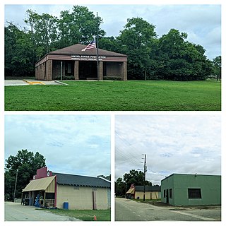
Rembert is a town in Sumter County, South Carolina, United States. The population was 306 at the 2010 census, a decline from 406 in 2000. It is included in the Sumter, South Carolina Metropolitan Statistical Area.

Shiloh is a census-designated place (CDP) in Sumter County, South Carolina, United States. The population was 259 at the 2000 census. It is included in the Sumter, South Carolina Metropolitan Statistical Area.

<span class="mw-page-title-main">South Sumter, South Carolina</span> CDP in South Carolina, United States

South Sumter is a census-designated place (CDP) in Sumter County, South Carolina, United States. The population was 3,365 at the 2000 census. It is included in the Sumter, South Carolina Metropolitan Statistical Area.

Stateburg is a census-designated place (CDP) in the High Hills of Santee in Sumter County, South Carolina, United States. The population was 1,380 at the 2010 census. It is included in the Sumter, South Carolina Metropolitan Statistical Area. Stateburg is located within the larger Stateburg Historic District.

Wedgefield is a census-designated place (CDP) in Sumter County, South Carolina, United States. The population was 1,544 at the 2000 census.

References

  1. "ArcGIS REST Services Directory". United States Census Bureau. Retrieved October 15, 2022.
  2. "Census Population API". United States Census Bureau. Retrieved October 15, 2022.
  3. 1 2 "U.S. Census website". United States Census Bureau . Retrieved January 31, 2008.
  4. "US Board on Geographic Names". United States Geological Survey. October 25, 2007. Retrieved January 31, 2008.
  5. "US Gazetteer files: 2010, 2000, and 1990". United States Census Bureau. February 12, 2011. Retrieved April 23, 2011.
  6. "Census of Population and Housing". Census.gov. Retrieved June 4, 2016.