Rembert, South Carolina

Last updated

Rembert, South Carolina
Rembert SC.jpg
USA South Carolina location map.svg
Red pog.svg
Rembert, South Carolina
Location within the state of South Carolina
Coordinates: 34°6′2″N80°31′51″W / 34.10056°N 80.53083°W / 34.10056; -80.53083
Country United States
State South Carolina
County Sumter
Area
[1]
  Total3.84 sq mi (9.94 km2)
  Land3.84 sq mi (9.94 km2)
  Water0.00 sq mi (0.00 km2)
Elevation
220 ft (67 m)
Population
 (2020) [2]
  Total246
  Density64.13/sq mi (24.76/km2)
Time zone UTC-5 (Eastern (EST))
  Summer (DST) UTC-4 (EDT)
ZIP code
29128
Area code(s) 803 and 839
FIPS code 45-59470 [3]
GNIS feature ID1231717 [4]

Rembert is a town in Sumter County, South Carolina, United States. The population was 306 at the 2010 census, a decline from 406 in 2000. It is included in the Sumter, South Carolina Metropolitan Statistical Area.

Contents

History

Ellerbe's Mill was listed on the National Register of Historic Places in 1974. [5]

Geography

Rembert is located at 34°06′02″N80°31′51″W / 34.100532°N 80.530842°W / 34.100532; -80.530842 . [6]

According to the United States Census Bureau, the CDP has a total area of 4.4 square miles (11.4 km2), all land. It is named after Huguenot Frenchman, Andre Rembert (1661-1736), immigrant to South Carolina.

Demographics

Historical population
CensusPop.Note
2020 246
U.S. Decennial Census [7]

As of the census [3] of 2000, there were 406 people, 144 households, and 101 families residing in the CDP. The population density was 92.1 inhabitants per square mile (35.6/km2). There were 163 housing units at an average density of 37.0 per square mile (14.3/km2). The racial makeup of the CDP was 24.14% White, 75.62% African American, 0.25% from other races. Hispanic or Latino of any race were 1.48% of the population.

There were 144 households, out of which 32.6% had children under the age of 18 living with them, 37.5% were married couples living together, 25.0% had a female householder with no husband present, and 29.2% were non-families. 24.3% of all households were made up of individuals, and 6.9% had someone living alone who was 65 years of age or older. The average household size was 2.82 and the average family size was 3.42.

In the CDP, the population was spread out, with 33.5% under the age of 18, 9.4% from 18 to 24, 26.6% from 25 to 44, 18.5% from 45 to 64, and 12.1% who were 65 years of age or older. The median age was 33 years. For every 100 females, there were 82.9 males. For every 100 females age 18 and over, there were 75.3 males.

The median income for a household in the CDP was $18,958, and the median income for a family was $25,417. Males had a median income of $19,911 versus $16,875 for females. The per capita income for the CDP was $9,528. About 26.5% of families and 30.8% of the population were below the poverty line, including 44.2% of those under age 18 and 51.3% of those age 65 or over.

Related Research Articles

<span class="mw-page-title-main">Gorman, North Carolina</span> Census-designated place in North Carolina, United States

Gorman is a census-designated place (CDP) in Durham County, North Carolina, United States. The population was 1,011 at the 2010 census.

<span class="mw-page-title-main">North Hartsville, South Carolina</span> Census-designated place in South Carolina, United States

North Hartsville is a census-designated place (CDP) in Darlington County, South Carolina, United States. The population was 3,251 at the 2010 census. It is part of the Florence Metropolitan Statistical Area and the Hartsville Urban Cluster.

<span class="mw-page-title-main">Lake Murray of Richland, South Carolina</span> Census-designated place in South Carolina, United States

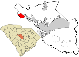
Lake Murray of Richland is a census-designated place (CDP) in Richland County, South Carolina, United States. The population was 5,484 at the 2010 census. It is part of the Columbia, South Carolina Metropolitan Statistical Area.

<span class="mw-page-title-main">Woodfield, South Carolina</span> Census-designated place in South Carolina, United States

Woodfield is a census-designated place (CDP) in Richland County, South Carolina, United States. The population was 9,303 at the 2010 census. It is part of the Columbia, South Carolina Metropolitan Statistical Area.

Cane Savannah is a census-designated place (CDP) in Sumter County, South Carolina, United States. The population was 1,452 at the 2000 census. It is included in the Sumter, South Carolina Metropolitan Statistical Area.

<span class="mw-page-title-main">Cherryvale, South Carolina</span> CDP in South Carolina, United States

Cherryvale is a census-designated place (CDP) in Sumter County, South Carolina, United States. The population was 2,461 at the 2000 census. It is included in the Sumter, South Carolina Metropolitan Statistical Area.

Dalzell is a census-designated place (CDP) in Sumter County, South Carolina, United States. The population was 3,175 at the 2020 census. It is included in the Sumter, South Carolina Metropolitan Statistical Area.

<span class="mw-page-title-main">East Sumter, South Carolina</span> CDP in South Carolina, United States

East Sumter is a census-designated place (CDP) in Sumter County, South Carolina, United States. The population was 1,220 at the 2000 census. It is included in the Sumter, South Carolina Metropolitan Statistical Area.

Lakewood is a census-designated place (CDP) in Sumter County, South Carolina, United States. The population was 2,603 at the 2000 census. It is included in the Sumter, South Carolina Metropolitan Statistical Area.

<span class="mw-page-title-main">Millwood, South Carolina</span> CDP in South Carolina, United States

Millwood is a census-designated place (CDP) in Sumter County, South Carolina, United States. The population was 885 at the 2000 census. It is included in the Sumter, South Carolina Metropolitan Statistical Area.

<span class="mw-page-title-main">Mulberry, South Carolina</span> CDP in South Carolina, United States

Mulberry is a census-designated place (CDP) in Sumter County, South Carolina, United States. The population was 841 at the 2000 census. It is included in the Sumter, South Carolina Metropolitan Statistical Area.

<span class="mw-page-title-main">Oakland, South Carolina</span> CDP in South Carolina, United States

Oakland is a census-designated place (CDP) in Sumter County, South Carolina, United States. The population was 1,272 at the 2000 census. It is included in the Sumter, South Carolina Metropolitan Statistical Area. Part of the area of the census-designated place is located within the Stateburg Historic District

Oswego is a census-designated place (CDP) in Sumter County, South Carolina, United States. The population was 95 at the 2000 census. It is included in the Sumter, South Carolina Metropolitan Statistical Area.

<span class="mw-page-title-main">Pinewood, South Carolina</span> Town in South Carolina, United States

Pinewood is a town located on South Carolina Highway 261 at the southern entrance to the High Hills of Santee in Sumter County, South Carolina, United States. The population was 538 at the 2010 census. It is included in the Sumter, South Carolina Metropolitan Statistical Area.

Privateer is a census-designated place (CDP) in Sumter County, South Carolina, United States. The population was 2,118 at the 2000 census. It is included in the Sumter, South Carolina Metropolitan Statistical Area.

Shiloh is a census-designated place (CDP) in Sumter County, South Carolina, United States. The population was 259 at the 2000 census. It is included in the Sumter, South Carolina Metropolitan Statistical Area.

<span class="mw-page-title-main">South Sumter, South Carolina</span> CDP in South Carolina, United States

South Sumter is a census-designated place (CDP) in Sumter County, South Carolina, United States. The population was 3,365 at the 2000 census. It is included in the Sumter, South Carolina Metropolitan Statistical Area.

Stateburg is a census-designated place (CDP) in the High Hills of Santee in Sumter County, South Carolina, United States. The population was 1,380 at the 2010 census. It is included in the Sumter, South Carolina Metropolitan Statistical Area. Stateburg is located within the larger Stateburg Historic District.

Wedgefield is a census-designated place (CDP) in Sumter County, South Carolina, United States. The population was 1,544 at the 2000 census.

<span class="mw-page-title-main">Ladson, South Carolina</span> Census-designated place in South Carolina, United States

Ladson is a census-designated place (CDP) in Berkeley, Charleston and Dorchester counties in the U.S. state of South Carolina. The population was 13,790 at the 2010 census. It is named in honor of the Ladson family, one of the oldest planter and merchant families in the Charleston area; one of its members was lieutenant governor James Ladson.

References

  1. "ArcGIS REST Services Directory". United States Census Bureau. Retrieved October 15, 2022.
  2. "Census Population API". United States Census Bureau. Retrieved October 15, 2022.
  3. 1 2 "U.S. Census website". United States Census Bureau . Retrieved January 31, 2008.
  4. "US Board on Geographic Names". United States Geological Survey. October 25, 2007. Retrieved January 31, 2008.
  5. "National Register Information System". National Register of Historic Places . National Park Service. July 9, 2010.
  6. "US Gazetteer files: 2010, 2000, and 1990". United States Census Bureau. February 12, 2011. Retrieved April 23, 2011.
  7. "Census of Population and Housing". Census.gov. Retrieved June 4, 2016.