
Wayne County is the most populous county in the U.S. state of Michigan. As of 2020, the United States Census placed its population at 1,793,561, making it the 19th-most populous county in the United States. The county seat is Detroit. The county was founded in 1796 and organized in 1815. Wayne County is included in the Detroit-Warren-Dearborn, MI Metropolitan Statistical Area. It is one of several U.S. counties named after Revolutionary War-era general Anthony Wayne.

Berlin Charter Township is a charter township of Monroe County in the U.S. state of Michigan. At the 2020 census, the township population was 9,890.

Brownstown Charter Township is a charter township in Wayne County in the U.S. state of Michigan. Its population was 30,627 at the 2010 census. Brownstown was established in 1827, a decade prior to Michigan's admission to the Union.
M-3, known for most of its length as Gratiot Avenue, is a north–south state trunkline highway in the Detroit metropolitan area of the US state of Michigan. The trunkline starts in Downtown Detroit and runs through the city in a northeasterly direction along one of Detroit's five major avenues. The highway passes several historic landmarks and through a historic district. It also connects residential neighborhoods on the city's east side with suburbs in Macomb County and downtown.

King's Highway 3, commonly referred to as Highway 3, is a provincially maintained highway in the Canadian province of Ontario which travels parallel to the northern shoreline of Lake Erie. It has three segments, the first of which travels from the Ambassador Bridge in Windsor to Highway 77 in Leamington. The second portion begins at Talbotville Royal outside of St. Thomas at Highway 4, and travels to the western city limits of Port Colborne. The road is regionally maintained within Port Colborne as Niagara Regional Road 3, but regains its provincial designation at Highway 140. Its third and final terminus is at Edgewood Park, within the Fort Erie town limits. From there, the road continues as Niagara Regional Road 3 to the Peace Bridge, where drivers can cross to the United States. The total length of Highway 3 is 258.2 km (160.4 mi), consisting of 49.2 km (30.6 mi) from Windsor to Leamington, 187.9 km (116.8 mi) from Talbotville Royal to Port Colborne and 21.1 km (13.1 mi) from Port Colborne to Edgewood Park.

The Battles of Frenchtown, also known as the Battle of the River Raisin and the River Raisin Massacre, were a series of conflicts in Michigan Territory that took place from January 18–23, 1813, during the War of 1812. It was fought between the United States of America and a joint force of British and Native Americans near the River Raisin in Frenchtown.

Charles Chouteau Gratiot was born in St. Louis, Spanish Upper Louisiana Territory, now the present-day State of Missouri. He was the son of Charles Gratiot, Sr., a fur trader in the Illinois country during the American Revolution, and Victoire Chouteau, who was from an important mercantile family. His father became a wealthy merchant, during the early years of St. Louis. After 1796, Charles was raised in the large stone house purchased by his father in St. Louis, near the Mississippi River. He made a career out of being a U.S. Army military engineer, becoming the Chief Engineer of the United States Corps of Engineers, and supervised construction of a number of important projects. He was dismissed by William Henry Harrison, which led to a protracted controversy.

A corduroy road or log road is a type of road or timber trackway made by placing logs, perpendicular to the direction of the road over a low or swampy area. The result is an improvement over impassable mud or dirt roads, yet rough in the best of conditions and a hazard to horses due to shifting loose logs.

The Treaty of Fort Meigs, also called the Treaty of the Maumee Rapids, formally titled, "Treaty with the Wyandots, etc., 1817", was the most significant Indian treaty by the United States in Ohio since the Treaty of Greenville in 1795. It resulted in cession by bands of several tribes of nearly all their remaining Indian lands in northwestern Ohio. It was the largest wholesale purchase by the United States of Indian land in the Ohio area. It was also the penultimate one; a small area below the St. Mary's River and north of the Greenville Treaty Line was ceded in the Treaty of St. Mary's in 1818.
The Battle of Brownstown was an early skirmish in the War of 1812. Although the United States military outnumbered the forces of Tecumseh's Confederacy 8 to 1, they lost the battle and suffered substantial losses while Tecumseh's forces were almost untouched.

Mongaugon Township, is a former township of Wayne County in the U.S. state of Michigan. Quarries including the DTE Energy Sibley Quarry that mines, gray limestone and celestine associated with calcite, fluorite, gypsum, epsomite, and rarely, sulfur were first worked by the French circa 1749. United States forces aided by Muskrat French defeated United Kingdom aided by Native Americans forces at the Battle of Monguagon during the War of 1812.
The Army of the Northwest was a U.S. Army unit formed at the outset of the War of 1812 and charged with control of the state of Ohio, the Indiana Territory, Michigan Territory and Illinois Territory.

US Highway 25 (US 25) was a part of the United States Numbered Highway System in the state of Michigan that ran from the Ohio state line near Toledo and ended at the tip of The Thumb in Port Austin. The general routing of this state trunkline highway took it northeasterly from the state line through Monroe and Detroit to Port Huron. Along this southern half, it followed undivided highways and ran concurrently along two freeways, Interstate 75 (I-75) and I-94. Near the foot of the Blue Water Bridge in Port Huron, US 25 turned north and northwesterly along the Lake Huron shoreline to Port Austin.

The Detroit metropolitan area in southeast Michigan is served by a comprehensive network of roads and highways. Three primary Interstate Highways pass through the region, along with three auxiliary Interstates, and multiple state and U.S. Highways. These are supplemented by the Mile Road System, a series of local roads spaced one mile apart on a perpendicular grid.

The River Raisin National Battlefield Park preserves the site of the Battle of Frenchtown as the only national battlefield marking a site of the War of 1812. It was established as the 393rd unit of the United States National Park Service under Title VII of the Omnibus Public Land Management Act, which was signed into law on March 30, 2009. The park is located in the city of Monroe in Monroe County, Michigan. It was designated as a Michigan Historic Site on February 18, 1956 and was added to the National Register of Historic Places on December 10, 1982. The house at 1403 East Elm Avenue was added to the National Register listing in 2019. It officially began operation as a national park unit on October 22, 2010.

Pointe Mouillee State Game Area is a state game area in the U.S. state of Michigan. It encompasses 7,483 acres (30.3 km2) of hunting, recreational, and protected wildlife and wetland areas at the mouth of the Huron River at Lake Erie, as well as smaller outlying areas within the Detroit River. Pointe Mouillee State Game Area was established in 1945 and is administered by the Michigan Department of Natural Resources.

The Jefferson Avenue–Huron River and Harbin Drive–Silver Creek Canal Bridges are two separate bridges, sharing a continuous railing, that were jointly listed on the National Register of Historic Places on February 10, 2000.
Roundhead, also known as Bark Carrier, Round Head, Stayeghtha, and Stiahta, was an American Indian chief of the Wyandot tribe. He was a strong member of Tecumseh's confederacy against the United States during the War of 1812. He died of unknown natural causes about a month or two before Tecumseh was killed at the Battle of the Thames.
During the War of 1812, Ohio was on the front lines in the conflict between the United States, Great Britain, Canadians, and the Native American allies of each side. Fighting raged in the northeastern section of the state and on the adjacent Lake Erie.
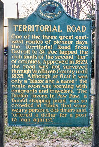
Territorial Road was the first main road through Michigan, from Detroit to Chicago, Illinois. In the 19th century, it led people from the Eastern United States through Michigan Territory. It was also called the Chicago Road.


