History
The district was laid out in 1893 by developed by John W. Leggett, Frank E. Snow, and Joseph C. Hough. Ninety-two lots were platted and each given a name (such as Tanglewood, Thisteldown, and Sorrento) in the original plat. The developers placed a number of restrictions on the area to ensure an attractive community. This quiet boulevard attracted a mix of businessmen and professionals. The first houses were constructed in 1895. By 1908 more than two dozen houses had been constructed in the district. [2]
By 1910, homeowners became concerned about the effect of the increasing commercialization of Woodward Avenue on property values, and they formed the Virginia Avenue Improvement Association. The association proposed to re-landscape the subdivision, and it developed an attractive entrance to the community. The neighborhood continued to thrive during the 1920s. It suffered in the 1930s from the Great Depression, the effects of which continued through the 1940s. [2]
By the 1950s and 1960s, many of the houses had absentee landlords, or were divided into rooming houses. The Algiers Motel, at one time located at the corner of Virginia Park and Woodward, was the scene of an incident of police brutality during the 1967 Detroit riot where three men were killed and others were beaten. [2]
In 1979, General Motors announced its plan to renovate the area north of its World Headquarters. This fostered rehabilitation in the Virginia Park district. The Algiers Motel was demolished in 1979, and replaced with a park space. [3] The Virginia Park Historic District is considered to mark the northern boundary of the New Center area of Detroit.
In 2022, one of Detroit's last remaining brick streets, built in 1907 in Virginia Park, began a $2 million rehabilitation. Stretching three blocks along Virginia Park Street between Woodward Ave, and the Lodge Freeway. As many as 20,000 age-appropriate Nelsonville block pavers have been assembled for the repair work. [4] [5]
Description
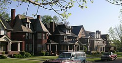
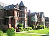
The Virginia Park District was platted as a series of lots 50 feet wide and 163 feet deep. The original restrictions in the neighborhood ensured a uniformity in the streetscape. All buildings are constructed of brick or stone, and have the same setback from the street. All are single family houses, with no more than one house on each fifty foot lot. [2]
At the time of its historic designation, the district included 57 structures, all but three of which contribute to the historic character of neighborhood. Non-contributing structures included an apartment building at 650 Virginia Park, an office building at 613 Virginia Park, and a hospital (demolished in 2014) [6] at 801-831 Virginia Park. Fifty-one of the contributing structures were used as homes, two as offices and one as a rest home. The residences were constructed between 1895 and 1915, with the older structures placed closer to Woodward, and newer ones, in general, farther westward.

Indian Village is a neighborhood located in Detroit, Michigan, bounded to the north and south by Mack Avenue and East Jefferson Avenue, respectively, along the streets of Burns, Iroquois, and Seminole. The district was listed on the National Register of Historic Places in 1972.

Corktown is a neighborhood located in Detroit, Michigan. It is the oldest extant neighborhood in the city. The current boundaries of the district include I-75 to the north, the Lodge Freeway to the east, Bagley and Porter streets to the south, and Rosa Parks Boulevard to the west. The neighborhood was listed on the National Register of Historic Places in 1978.

Woodbridge is a historic neighborhood of primarily Victorian homes located in Detroit, Michigan. The district was listed on the National Register of Historic Places in 1980, with later boundary increases in 1997 and 2008. In addition to its historic value, Woodbridge is also notable for being an intact neighborhood of turn-of-the-century homes within walking or biking distance of Detroit's Downtown, Midtown, New Center, and Corktown neighborhoods.

The Grand Circus Park Historic District contains the 5-acre (2.0 ha) Grand Circus Park in Downtown Detroit, Michigan that connects the theatre district with its financial district. It is bisected by Woodward Avenue, four blocks north of Campus Martius Park, and is roughly bounded by Clifford, John R. and Adams Streets. The district was listed on the National Register of Historic Places in 1983. The building at 25 West Elizabeth Street was added to the district in 2000, and additional structures located within the district, but built between 1932 and 1960, were approved for inclusion in 2012.

Midtown Detroit is a commercial and residential district located along the east and west side of Woodward Avenue, north of Downtown Detroit, and south of the New Center area. The area includes several historic districts. In addition, it contains a residential area of some 14,550 people and covers 2.09 sq mi. The community area of neighborhoods is bounded by the Chrysler Freeway (I-75) on the east, the Lodge Freeway (M-10) on the west, the Edsel Ford Freeway (I-94) on the north, and the Fisher Freeway (I-75) on the south.

The Brush Park Historic District is a neighborhood located in Detroit, Michigan. It is bounded by Mack Avenue on the north, Woodward Avenue on the west, Beaubien Street on the east, and the Fisher Freeway on the south. The Woodward East Historic District, a smaller historic district completely encompassed by the larger Brush Park neighborhood, is located on Alfred, Edmund, and Watson Streets, from Brush Street to John R. Street, and is recognized by the National Register of Historic Places.

1001 Woodward is a 25-floor office building in Downtown Detroit, Michigan. It replaced the Majestic Building, a 14-story high rise on the same site. The building is located just south of the neighboring David Stott Building, at the corner of Woodward Avenue and Michigan Avenue overlooking Campus Martius Park. Constructed from 1963 to 1965, the building is designed in the International Style. It was listed on the National Register of Historic Places in 2013.

The architecture of metropolitan Detroit continues to attract the attention of architects and preservationists alike. With one of the world's recognizable skylines, Detroit's waterfront panorama shows a variety of architectural styles. The post-modern neogothic spires of One Detroit Center refer to designs of the city's historic Art Deco skyscrapers. Together with the Renaissance Center, they form the city's distinctive skyline.

Washington Boulevard Historic District is a multi-block area of downtown Detroit, Michigan. It consists of structures facing Washington Boulevard between State and Clifford Streets. In 1982, it was added to the National Register of Historic Places. It includes the Book-Cadillac Hotel, the Book Tower, the Industrial Building, and Detroit City Apartments among other architecturally significant buildings. Washington Boulevard is one of the city's main boulevards and part of Augustus Woodward's 1807-design for the city. Because Woodward's plan was never completed, the boulevard contains a sharp curve south of Michigan Avenue where it was connected to an existing street.

The Wright–Kay Building, originally known as the Schwankovsky Temple of Music, is one of the oldest buildings in downtown Detroit, Michigan. It is located at 1500 Woodward Avenue, at the corner of Woodward and John R. Street, in proximity to the Lower Woodward Avenue Historic District. The building was listed on the State of Michigan's Historical Register in 1980 as #P25241.

The Cultural Center Historic District is a historic district located in Detroit, Michigan, which includes the Art Center : the Detroit Public Library, the Detroit Institute of Arts, and the Horace H. Rackham Education Memorial Building were listed on the National Register of Historic Places in 1983. The district contains several cultural attractions.

The Religious Structures of Woodward Avenue Thematic Resource (TR) is a multiple property submission to the National Register of Historic Places which was approved on August 3, 1982. The structures are located on Woodward Avenue in the cities of Detroit and Highland Park, Michigan.

The East Ferry Avenue Historic District is a historic residential district in Midtown Detroit, Michigan. The nationally designated historic district stretches two blocks from Woodward Avenue east to Brush Street; the locally designated historic district includes a third block between Brush and Beaubien. The district includes the separately designated Col. Frank J. Hecker House and the Charles Lang Freer House. It was designated a Michigan State Historic Site in 1976 and listed on the National Register of Historic Places in 1980.

This is a list of the National Register of Historic Places listings in Detroit, Michigan.

The Palmer Woods Historic District is a neighborhood located in Detroit, Michigan, bounded by Seven Mile Road, Woodward Avenue, and Strathcona Drive. There are approximately 295 homes in the 188-acre (0.76 km2) district, which is between the City of Highland Park in Wayne County and the City of Ferndale in Oakland County. It was listed on the National Register of Historic Places in 1983. The Detroit Golf Club is nearby.

The University–Cultural Center MRA is a pair of multiple property submissions to the National Register of Historic Places which were approved on April 29 and May 1, 1986. The structures included are all located in Midtown, near Woodward Avenue and Wayne State University in Detroit, Michigan. The two submissions are designated the University–Cultural Center MRA Phase I, containing five properties, and the University–Cultural Center MRA Phase II, containing three properties.

The Park Avenue Hotel was a hotel in the Cass Corridor of Detroit, Michigan. It was listed on the National Register of Historic Places in 2006. It was also known as Salvation Army Harbor Light Center and is not to be confused with Park Avenue House, also once known as Park Avenue Hotel. The building was imploded on July 11, 2015.

This is a list of the National Register of Historic Places listings in Downtown and Midtown Detroit, Michigan. It is intended to be a complete list of the properties and districts on the National Register of Historic Places in Downtown and Midtown neighborhoods in Detroit, Michigan, United States. Latitude and longitude coordinates are provided for many National Register properties and districts; these locations may be seen together in online maps.
The Michigan Avenue Historic Commercial District in Detroit is a group of commercial buildings located along the south side of two blocks of Michigan Avenue, from 3301–3461. This section of buildings is the most intact collection along this stretch of Detroit's Michigan Avenue. The district was listed on the National Register of Historic Places in 2020.