
The Great Basin Desert is part of the Great Basin between the Sierra Nevada and the Wasatch Range. The desert is a geographical region that largely overlaps the Great Basin shrub steppe defined by the World Wildlife Fund, and the Central Basin and Range ecoregion defined by the U.S. Environmental Protection Agency and United States Geological Survey. It is a temperate desert with hot, dry summers and snowy winters. The desert spans a large part of the state of Nevada, and extends into western Utah, eastern California, and Idaho. The desert is one of the four biologically defined deserts in North America, in addition to the Mojave, Sonoran, and Chihuahuan Deserts.

Great Shunner Fell is the third highest mountain in the Yorkshire Dales, North Yorkshire, England, and the highest point in Wensleydale; at 716 metres above sea level. In clear weather the summit affords views of Wensleydale to the south, Ribblesdale to the south west and Swaledale to the north, as well as views into Cumbria and County Durham beyond the A66.

Aire Point to Carrick Du SSSI is a Site of Special Scientific Interest on the Penwith Peninsula, Cornwall, England. It is 5.98 square kilometres in extent, stretching from grid reference SW360279 to grid reference SW513410. The site is designated both for its biological and its geological interest.

Windsor Hill is a 61.8 hectare biological Site of Special Scientific Interest in Princes Risborough in Buckinghamshire. It lies within the Chilterns Area of Outstanding Natural Beauty, and it is featured in the Nature Conservation Review. A small part is managed by the Berkshire, Buckinghamshire and Oxfordshire Wildlife Trust, and access to this area requires a permit.

Whitton Bridge Pasture is a Site of Special Scientific Interest (SSSI) in the unitary authority of Stockton-on-Tees, England. At 3.18 hectares (7.9 acres) it lies to the south of Whitton village and north west of Stockton-on-Tees. SSSIs are chosen by Natural England, and Whitton Bridge Pasture was designated in 2004 because of its biological interest. It is one of 18 SSSIs in the Cleveland area of search.

The woodlands of the Iberian Peninsula are distinct ecosystems on the Iberian Peninsula. Although the various regions are each characterized by distinct vegetation, the borders between these regions are not clearly defined, and there are some similarities across the peninsula.
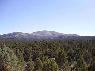
Pinyon–juniper woodland, also spelled piñon–juniper woodland, is a vegetation type (biome) of Western United States higher elevation deserts, characterized by being an open forest dominated by low, bushy, evergreen junipers, pinyon pines, and their associates which vary from region to region. The woodland's crown height may vary from less than 10 meters up to 15 meters, depending on the site. It may consist of pure stands of pinyon pine, or pure stands of juniper.

Waldridge Fell is a Site of Special Scientific Interest located immediately south-west of Chester-le-Street in the northern part of County Durham, England. It is one of the largest areas of lowland heath in County Durham and contains the only lowland valley-mire in the county. The fell is home to a number of plants and insects that are scarce to rare elsewhere in the county.
Far High House Meadows is a Site of Special Scientific Interest in Upper Weardale in west County Durham, England. It consists of three fields, located just south of Burnhope Reservoir, some 3 km west of the village of Ireshopeburn. Two of the fields are maintained as northern hay meadows by traditional farming methods, without re-seeding or the application of artificial fertilisers; the third is grazed as pasture.

Hell Kettles is a Site of Special Scientific Interest in the Darlington district of County Durham, England. It was designated for its biological interest as the only site in County Durham where there is a body of water fed by springs.
Hesledon Moor East is a Site of Special Scientific Interest in the Easington district in east County Durham, England. It is located on the southern edge of the village of Murton, 10 km south of Sunderland and a little under 2 km north-east of Hesledon Moor West SSSI.
Lune Forest is a Site of Special Scientific Interest covering an extensive area of moorland in the Teesdale district of west Durham, England. In the north, where it adjoins the Upper Teesdale and Appleby Fells SSSIs, it extends from Mickle Fell eastward almost as far as Harter Fell, above the hamlet of Thringarth. Its southern limit is marked by the River Balder, upstream from Balderhead Reservoir, where it shares a boundary with Cotherstone Moor SSSI to the south. Grains o' th' Beck Meadows and Close House Mine SSSIs are entirely surrounded by Lune Forest, but do not form part of it.
Westernhope Burn Wood is a Site of Special Scientific Interest in the Wear Valley district of south-west County Durham, England. It occupies the steeply-incised ravine of the Westernhope Burn, a tributary of the River Wear, which it joins from the south about halfway between the villages of Eastgate and Westgate.
Middleton Quarry is a Site of Special Scientific Interest in the Teesdale district of west County Durham, England. It is a disused quarry, from which Whin Sill stone was formerly excavated. It lies just south of the River Tees, opposite the village of Middleton-in-Teesdale on the river's northern bank.
Muggleswick, Stanhope and Edmundbyers Commons and Blanchland Moor is a Site of Special Scientific Interest in County Durham and Northumberland, England. It consists of two separate areas, the larger—encompassing the upland areas of Muggleswick, Stanhope and Edmundbyers Commons—in the Derwentside and Wear Valley districts of north Durham, the smaller—Blanchland Moor—in the Tynedale district of south-west Northumberland.
Park End Wood is a Site of Special Scientific Interest in the Teesdale district of west County Durham, England. The site occupies a low hill of Whin Sill on the southern edge of the River Tees floodplain just over 2 km upstream from the village of Middleton-in-Teesdale. It adjoins the Upper Teesdale SSSI to the south, and the Middle Crossthwaite and Stonygill Meadows SSSIs are nearby.
Sleightholme Beck Gorge – The Troughs is a Site of Special Scientific Interest in the Teesdale district of south-west County Durham, England. The site covers a gorge in the valley of Sleightholme Beck between the hamlet of Sleightholme and the confluence with the River Greta, some 3 km upriver from the village of Bowes.

Minchinhampton Common is a 182.7-hectare (451-acre) biological and geological Site of Special Scientific Interest in Gloucestershire, notified in 1972.

Hirpora Wildlife Sanctuary or Heerpora Wildlife Sanctuary is located in Shopian district of Jammu and Kashmir, 70 kilometers south of Srinagar. It spreads over an area of 341 km2. It is bounded to the north by Lake Gumsar, northeast by Hirpora village, east by Rupri, south by Saransar and to the west by the Pir Panjal pass. The slopes are gentle to moderately steep on the eastern aspect and very steep with many cliffs on the higher northern and western aspect. The southern and southeastern portions are moderately steep.

