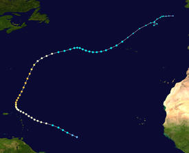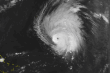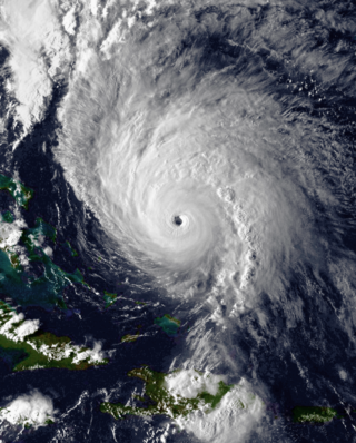
Hurricane Hortense was the first tropical cyclone to make landfall in Guadeloupe and Puerto Rico since Hurricane Hugo in 1989, and the second most intense hurricane during the 1996 Atlantic hurricane season. The eighth tropical cyclone, eighth named storm, and sixth hurricane of the season. Hortense developed on September 3 from a tropical wave in the central Atlantic Ocean. Initially a tropical depression, it headed westward without significant strengthening for four days due to unfavorable upper-level winds. While nearing the Lesser Antilles upper-level winds decreased, allowing the depression to become Tropical Storm Hortense on September 7. Hortense crossed Guadeloupe on September 8 and entered the Caribbean Sea. By on the following day, it was upgraded to a hurricane while curving northwestward. Hortense made landfall in Puerto Rico on September 9 and brushed the Dominican Republic shortly thereafter. After re-entering the Atlantic, Hortense began to substantially strengthen and peaked as a 140 mph (220 km/h) Category 4 hurricane early on September 13. Thereafter, the storm steadily weakened as it tracked rapidly north-northeastward. Early on September 15, Hortense made landfall in Nova Scotia as a minimal Category 1 hurricane. It quickly weakened further to a tropical storm before re-entering the Atlantic to the south of Newfoundland. Late on September 15, Hortense transitioned into an extratropical cyclone and subsequently merged with a frontal system about 24 hours later.
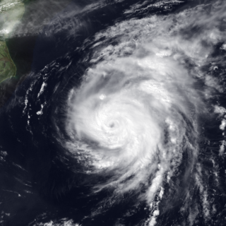
Hurricane Danielle was a long-lived Cape Verde hurricane in late August and early September 1998. The fourth named storm and second hurricane of the annual hurricane season, Danielle originated from a tropical wave that emerged off the western coast of Africa on August 21. Tracking generally west-northwestward, the disturbance was initially disorganized; under favorable atmospheric conditions, shower and thunderstorm activity began to consolidate around a low-pressure center. Following a series of satellite intensity estimates, the system was upgraded to Tropical Depression Four during the pre-dawn hours of August 24, and further to Tropical Storm Danielle that afternoon. Moving around the southern periphery of the Azores High located in the northeastern Atlantic, quick intensification to hurricane status occurred early on August 25. By 0600 UTC the following day, Danielle reached an initial peak intensity of 105 mph (169 km/h), a Category 2 hurricane. Increased wind shear from a nearby trough encroached on further development later that day, and subsequently led to slight weakening. By 1200 UTC on August 27, despite continued unfavorable conditions, Danielle reached a second peak intensity equal to the first. Weakening once ensued late on August 27 in addition to the days following, and Danielle was a low-end Category 1 hurricane by August 31 as its forward speed slowed.

The 2003 Atlantic hurricane season was a highly active Atlantic hurricane season with tropical activity before and after the official bounds of the season—the first such occurrence since the 1970 season. The season produced 21 tropical cyclones, of which 16 developed into named storms; seven of those attained hurricane status, of which three reached major hurricane status. With sixteen storms, the season was tied for the fifth-most active Atlantic hurricane season on record, although it has since dropped down to become the seventh most active season. The strongest hurricane of the season was Hurricane Isabel, which reached Category 5 status on the Saffir–Simpson hurricane scale northeast of the Lesser Antilles; Isabel later struck North Carolina as a Category 2 hurricane, causing $3.6 billion in damage and a total of 51 deaths across the Mid-Atlantic region of the United States.

The 1997 Atlantic hurricane season was a below-average hurricane season. It officially began on June 1, and lasted until November 30 of that year. These dates conventionally delimit the period of each year when most tropical cyclones form in the Atlantic basin. The 1997 season was fairly inactive, with only seven named storms forming, with an additional tropical depression and an unnumbered subtropical storm. It was the first time since the 1961 season that there were no active tropical cyclones in the Atlantic basin during the entire month of August–historically one of the more active months of the season—a phenomenon that would not occur again until 2022. A strong El Niño is credited with reducing activity in the Atlantic, while increasing the number of storms in the eastern and western Pacific basins to 19 and 26 storms, respectively. As is common in El Niño years, tropical cyclogenesis was suppressed in the tropical latitudes, with only two becoming tropical storms south of 25°N.

The 1963 Atlantic hurricane season featured one of the deadliest tropical cyclones on record in the Atlantic basin: Hurricane Flora. The season officially began on June 15, and lasted until November 15. These dates conventionally delimit the period of each year when most tropical cyclones form in the Atlantic basin. It was a slightly below average season in terms of tropical storms, with a total of ten nameable storms. The first system, an unnamed tropical storm, developed over the Bahamas on June 1. In late July, Hurricane Arlene, developed between Cape Verde and the Lesser Antilles. The storm later impacted Bermuda, where strong winds resulted in about $300,000 (1963 USD) in damage. Other storms such as hurricanes Beulah and Debra, as well as an unnamed tropical storm, did not impact land. During the month of September, Tropical Storm Cindy caused wind damage and flooding in Texas, leaving three deaths and approximately $12.5 million in damage. Hurricane Edith passed through the Lesser Antilles and the eastern Greater Antilles, causing 10 deaths and about $43 million in damage, most of which occurred on Martinique.

The 1970 Atlantic hurricane season officially began on June 1 and lasted until November 30. These dates conventionally delimit the period of each year when most tropical cyclones form in the Atlantic basin. The season was fairly average, with 14 named storms forming, of which seven were hurricanes. Two of those seven became major hurricanes, which are Category 3 or higher on the Saffir–Simpson scale. Also, this was the first season in which reconnaissance aircraft flew into all four quadrants of a tropical cyclone.
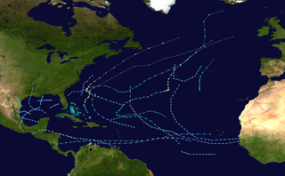
The 1978 Atlantic hurricane season was a slightly above average hurricane season in terms of number of named storms. Eleven tropical cyclones were named in all, and five of these became hurricanes; two of the five became a major hurricane. This was also the last Atlantic hurricane season to use an all-female naming list. The season officially began on June 1, 1978, and ended on November 30, 1978. These dates, adopted by convention, denote the period in each year when most tropical cyclogenesis occurs in the Atlantic basin. However, the formation of subtropical or tropical cyclones is possible at any time of the year, as shown by the formation of an unnamed subtropical storm on January 18.

The 1990 Atlantic hurricane season was the most active Atlantic hurricane season since 1969, with a total of 14 named storms. The season also featured eight hurricanes, one of which intensified into a major hurricane. It officially began on June 1, 1990, and lasted until November 30, 1990. These dates conventionally delimit the period of each year when most tropical cyclones form in the Atlantic basin. However, tropical cyclogenesis can occur prior to the start of the season, as demonstrated with Tropical Depression One, which formed in the Caribbean Sea on May 24.

The 1991 Atlantic hurricane season was the first season since 1984 in which no hurricanes developed from tropical waves, which are the source for most North Atlantic tropical cyclones. The hurricane season officially began on June 1, and ended on November 30. It was the least active in four years due to higher than usual wind shear across the Atlantic Ocean. The first storm, Ana, developed on July 2 off the southeast United States and dissipated without causing significant effects. Two other tropical storms in the season – Danny and Erika – did not significantly affect land. Danny dissipated east of the Lesser Antilles, and Erika passed through the Azores before becoming extratropical. In addition, there were four non-developing tropical depressions. The second depression of the season struck Mexico with significant accompanying rains.

The 1956 Atlantic hurricane season featured a decent number of tropical cyclones, although most tropical storms and hurricanes affected land. There were twelve tropical storms, a third of which became hurricanes. One of the hurricanes strengthened to the equivalent of a major hurricane, which is a Category 3 or greater on the Saffir–Simpson scale. The strongest hurricane of the season was Betsy, which was also the most damaging storm of the season: it destroyed 15,000 houses and left $40 million in damage in Puerto Rico. Betsy was also the deadliest of the season, having killed 18 people in the French West Indies, two from a shipwreck in the Caribbean Sea, and 16 in Puerto Rico. Tropical Storm Dora struck Mexico in September and killed 27 people.

The 1952 Atlantic hurricane season was the last Atlantic hurricane season in which tropical cyclones were named using the Joint Army/Navy Phonetic Alphabet. It was a near normal Atlantic hurricane season, although it was the least active since 1946. The season officially started on June 15; however, a pre-season unnamed storm formed on Groundhog Day, becoming the only storm on record in the month of February. The other six tropical cyclones were named using the Joint Army/Navy Phonetic Alphabet, the first of which formed on August 18. The final storm of the season dissipated on October 28, two and a half weeks before the season officially ended on November 15.

The 1949 Atlantic hurricane season was the last season that tropical cyclones were not publicly labeled by the United States Weather Bureau. It officially began on June 15, and lasted until November 15. These dates conventionally delimit the period of each year when most tropical cyclones form in the Atlantic basin. The first storm, a tropical depression, developed in the northern Gulf of Mexico on August 14. The final system, Tropical Storm Sixteen, dissipated in the southwestern Caribbean Sea on November 5. It was a fairly active season, featuring 16 tropical storms and seven hurricanes. Two of these strengthened into major hurricanes, which are Category 3 or higher on the Saffir–Simpson hurricane wind scale.

The 1899 Atlantic hurricane season featured the longest-lasting tropical cyclone in the Atlantic basin on record. There were nine tropical storms, of which five became hurricanes. Two of those strengthened into major hurricanes, which are Category 3 or higher on the modern day Saffir–Simpson hurricane wind scale. The first system was initially observed in the northeastern Gulf of Mexico on June 26. The tenth and final system dissipated near Bermuda on November 10. These dates fall within the period with the most tropical cyclone activity in the Atlantic. In post-season analysis, two tropical cyclones that existed in October were added to HURDAT – the official Atlantic hurricane database. At one point during the season, September 3 through the following day, a set of three tropical cyclones existed simultaneously.

Hurricane Jose was the fourteenth tropical cyclone, tenth named storm, and seventh hurricane of the annual season that caused moderate damage in the Lesser Antilles in October 1999. Jose developed from a tropical wave several hundred miles east of the Windward Islands on October 17. The depression intensified and was subsequently upgraded to Tropical Storm Jose on October 18. The storm tracked northwestward and was upgraded to a hurricane the following day as it approached the northern Leeward Islands. Jose briefly peaked as a Category 2 hurricane with winds of 100 mph (160 km/h) on October 20. However, wind shear weakened the storm back to a Category 1 hurricane before it struck Antigua. Further deterioration occurred and Jose weakened to a tropical storm before landfall in Tortola on October 21. While located north of Puerto Rico on October 22, the storm turned northward, shortly before curving north-northeastward. Wind shear decreased, allowing Jose to re-intensify into a hurricane while passing east of Bermuda on October 24. However, on the following day, wind shear increased again, while sea surface temperatures decreased, causing Jose to weaken and quickly transition into an extratropical cyclone.

Hurricane Iris was the first of three tropical cyclones to affect the Lesser Antilles in a three-week period, preceding the more destructive hurricanes Luis and Marilyn. The ninth named storm and fifth hurricane of the 1995 Atlantic hurricane season, Iris developed from a tropical wave to the east of the Lesser Antilles on August 22 and attained hurricane status within 30 hours. The hurricane weakened to a tropical storm before crossing the islands of the eastern Caribbean from August 26 through August 28. During that time, Iris became one of four active tropical storms in the Atlantic basin. Earlier it had interacted with Hurricane Humberto, and beginning on August 30, Iris interacted with Tropical Storm Karen. Iris re-intensified into a hurricane and attained peak sustained winds of 110 mph (175 km/h) while moving slowly across the central Atlantic. The hurricane accelerated to the north and absorbed a dissipating Karen on September 3. Iris weakened to a tropical storm and became extratropical on September 4, though its remnants re-attained hurricane-force winds, before affecting western Europe on September 7. The storm dissipated soon afterward.

Hurricane Gordon was the first tropical cyclone since 1992 to affect the Azores while retaining tropical characteristics. The eighth tropical storm, third hurricane, and first major hurricane of the 2006 Atlantic hurricane season, Gordon formed on September 10 in the tropical Atlantic Ocean. It gradually matured into a hurricane as it tracked northward, reaching its peak intensity with winds of 195 km/h (121 mph) early on September 14 while located about 925 km (575 mi) southeast of Bermuda. After becoming nearly stationary, Gordon weakened to minimal hurricane status, although it re-intensified after accelerating to the east. It weakened again after moving over cooler waters, and passed through the Azores on September 20. Shortly thereafter, it became an extratropical cyclone and subsequently affected Spain, Ireland, and the United Kingdom.
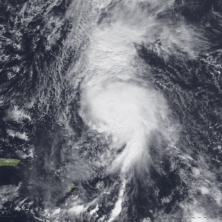
Hurricane Klaus was a North Atlantic hurricane that hit the Leeward Islands from the west in November of the 1984 Atlantic hurricane season. Forming from a broad area of low pressure on November 5, Klaus maintained a northeast movement throughout much of its path. After making landfall on extreme eastern Puerto Rico, it passed to the north of the Leeward Islands, resulting in strong southwesterly winds and rough seas. Klaus attained hurricane status and reached peak winds of 90 mph (145 km/h) before becoming extratropical over cooler waters on November 13. The storm dropped heavy rainfall in Puerto Rico, causing minor flooding and light damage. Klaus caused heavy marine damage in the Leeward Islands, including wrecking at least three ships. The Virgin Islands experienced heavy damage as well.

Tropical Storm Dean was a strong tropical storm that affected at least twelve islands along its path from the tropical Atlantic Ocean to east of Atlantic Canada in August 2001. Dean developed from a tropical wave on August 22 over the Lesser Antilles, and was initially predicted to intensify further to reach hurricane status. However, strong wind shear quickly weakened Dean to cause it to dissipate on August 23. The remnants turned northward, and redeveloped on August 26 to the north of Bermuda. Located over warm waters and in an area of favorable conditions, Dean steadily strengthened while moving to the northeast, and peaked just below hurricane status on August 27 about 465 miles (748 km) southwest of Newfoundland. The storm subsequently weakened over cooler waters, and became extratropical on August 28.

The 2009 Atlantic hurricane season was a below-average Atlantic hurricane season that produced eleven tropical cyclones, nine named storms, three hurricanes, and two major hurricanes. It officially began on June 1 and ended on November 30, dates that conventionally delimit the period of each year when most tropical cyclones develop in the Atlantic basin. The season's first tropical cyclone, Tropical Depression One, developed on May 28, while the final storm, Hurricane Ida, dissipated on November 10. The most intense hurricane, Bill, was a powerful Cape Verde-type hurricane that affected areas from the Leeward Islands to Newfoundland. The season featured the lowest number of tropical cyclones since the 1997 season, and only one system, Claudette, made landfall in the United States. Forming from the interaction of a tropical wave and an upper-level low, Claudette made landfall on the Florida Panhandle with maximum sustained winds of 45 mph (70 km/h) before quickly dissipating over Alabama. The storm killed two people and caused $228,000 in damage.

