Independence Mall (Philadelphia)

Last updated

Independence Mall
Philadelphia Independence Mall.jpg
Independence Mall in 2019, seen from the National Constitution Center.
Coordinates(Independence Mall): 39°57′03″N75°08′58″W / 39.9508°N 75.1495°W / 39.9508; -75.1495
Country United States
State Pennsylvania
County Philadelphia
City Philadelphia
Area
  Land15.5 acres (6.3 ha)
Area code(s) 215, 267 and 445

Independence Mall is a three-block section of Independence National Historical Park (INHP) in Philadelphia, Pennsylvania. It lies directly north of Independence Hall, and is bounded by Chestnut, Race, 5th and 6th Streets. The south block is called the First Block, the middle block is called the Second Block, and the north block is called the Third Block.[ citation needed ]

Contents

Buildings and structures on the Mall include the National Constitution Center (3rd block); the Independence Visitor Center and the Free Quaker Meetinghouse (2nd Block); and the President's House Memorial and the Liberty Bell Center (1st Block). A multi-level underground parking garage lies beneath much of the Second Block, and a small open-air café opened on the east side of the block in 2008. [1] Public restrooms and the "Peoples' Plaza" (First Amendment Area) are located on the First Block.

Buildings surrounding the Mall include Congress Hall, Independence Hall, and Old City Hall to the south; the Philadelphia Bourse, the National Museum of American Jewish History, Christ Church Burial Ground, and the Philadelphia Mint to the east; the approach to the Benjamin Franklin Bridge to the north; and WHYY-TV, the Federal Reserve Bank of Philadelphia, the James A. Byrne Federal Courthouse, and the Rohm & Haas Building to the west.

History

Conception

Independence Hall, with newly demolished First Block of Independence Mall, 1952. Independence Mall 1952 NPS photo.jpg
Independence Hall, with newly demolished First Block of Independence Mall, 1952.

The groundwork for a park area surrounding Independence Hall was laid when the Historic Sites Act of 1935 was adopted. Even before Independence Hall was officially named a National Historic Site in 1943, [2] Architect Roy F. Larson developed the original concept for the site now known as Independence Mall in 1937. His concept called for a 5-block mall extending from Chestnut to Callowhill Streets, and incorporating the approaches to the Benjamin Franklin Bridge. [3] and was strongly backed by the Independence Hall Association and its president, Judge Edwin O. Lewis. In 1947, as a national park was being assembled around Independence Hall, Lewis advocated that the federal government purchase the three blocks north of the historic building for the park. The National Park Service (NPS) was only interested in purchasing the First Block[ citation needed ]. His plan rejected, Lewis took the idea of a three-block mall to the Pennsylvania General Assembly, convincing legislators to build it as a state park and a monument to Pennsylvanians who had died in World War II, a concept that was never fully realized.

Independence Mall State Park was created in the 1950s with the intention that the land would eventually be turned over to the NPS. Funded by 40-year state bonds, its construction was a joint venture between Pennsylvania and the City of Philadelphia, and was overseen by Edmund Bacon, director of the Philadelphia City Planning Commission. A couple hundred 18th-, 19th-, and 20th-century buildings were purchased and demolished for the project. Among these were the surviving walls of the President's House – the "White House" of George Washington and John Adams during the decade (1790–1800) that Philadelphia served as the temporary national capital. The only building not demolished was the Free Quaker Meetinghouse at the southwest corner of 5th & Arch Streets. It was relocated 30 feet to the west, so that 5th Street could be widened. It is important to note that the original approved design(s) for the Mall were created without involvement from the National Park Service. [3]

The first block closest to Independence Mall was completed in 1954. The design for the first block was developed by Wheelwright, Stevenson and Langren, a Philadelphia Landscape Architecture Firm. By their design, the block featured a central lawn surrounded by terraces, walkways and a formal allée of trees. [4] The next block featured a central fountain and a square reflecting pool. It was also surrounded by terraces and two brick arcades to mimic the first block.

The northernmost block was designed by Dan Kiley, a Landscape Architect influential in the modernist style. His 1963 plan was designed based on Philadelphia's original five-city-square layout. Each "square" was represented by fountains placed in scale to the Center City map. Surrounding the fountains was a regularly spaced array of 700 Honey Locust trees planted 12'-6" by 18' on-center within a brick paved plaza. The trees ultimately failed due to the tight spacing and urban environment; many were removed, degrading the overall design intent. [4]

National Park Service Takeover

Independence Mall, circa 1959. The First Block (foreground) is completed. One third of the Second Block is completed, from Market to Filbert Streets, and named the "Judge Lewis Quadrangle." The other two-thirds, Filbert to Arch Streets, will become the underground parking garage, with a plaza above. The buildings on the Third Block have not yet been demolished. ARCH STREET STUDY - 503-527 Arch Street (Houses), Philadelphia, Philadelphia County, PA HABS PA,51-PHILA,466-2.tif
Independence Mall, circa 1959. The First Block (foreground) is completed. One third of the Second Block is completed, from Market to Filbert Streets, and named the "Judge Lewis Quadrangle." The other two-thirds, Filbert to Arch Streets, will become the underground parking garage, with a plaza above. The buildings on the Third Block have not yet been demolished.

Concurrent with construction activities through an Act of Congress on June 28, 1947, [3] the Independence National Historic Park (INHP) was created. When it was formally established and first opened to the public on July 4, 1956, [3] the National Park did not include any portion of the Mall. In 1972, the Mall was donated to the NPS and the boundary for the INHP was redefined. [5] In 1974, ownership and operation of the entire Mall was officially transferred to the NPS. [4]

Prior to 1976, the Liberty Bell was housed within Independence Hall. In preparation for the Bicentennial celebration, the National Historical Park Advisory Committee made a proposal to have the Liberty Bell relocated outside of Independence Hall as the building was not able to accommodate the millions of visitors expected. The initial plan of 1972 to relocate the Liberty Bell to South Third Street and Chestnut, two blocks east, was met with resistance from residents of the city. An alternate plan was suggested in 1973 to construct a smaller pavilion north of Independence Hall between Race and Arch Streets, but that plan was also met with resistance. Mayor Frank Rizzo then suggested that the pavilion be placed in the block immediately north of the famous building. It was this later idea that prevailed and the plans were drafted to construct the new glass and steel pavilion at the north end of the first block of Independence Mall near Market Street. Designed by Romaldo Giurgola in 1974, ground breaking for construction occurred early in 1975. Later the same year, the Liberty Bell Pavilion would be complete. The bell was relocated as part of the New Years Eve celebration and the Pavilion first opened to the public on January 1, 1976 at 12:01 am. [6] This would be the official home of the Liberty Bell until October 9, 2003. [7]

In 1997, Independence Mall State Park was renamed and is now known as Independence National Historical Park. [4]

Renovation

Independence Mall. Independence-park-map.jpg
Independence Mall.

A new master plan for the Independence National Historical Park was developed by the Landscape Architecture firm Olin Partnership (now known simply as OLIN). [4] The extensive redesign proposed the removal of all previous structures, except the Free Quaker Meetinghouse. It proposed to focus all of the proposed buildings along 6th Street at the western edge of the park with smaller pocket parks along 5th Street to the east. The smaller parks along the eastern edge, some of which were raised above the central lawn, would provide more intimate gathering and sitting areas with extensive trees and other landscaping. Several straight brick pathways carved each of the lawn areas within each block including two lateral cuts through the first block corresponding to Ranstead Street and Ludlow Street to the east of the park. There was also a meandering curved path that connected the southeast corner at 5th and Chestnut Streets to the National Constitution Center at the north end of the park.

Current Layout

Today, Independence Mall still consists of the original three blocks from the early 1945 concept. However, due to the redevelopment, several new features and buildings have been added to the overall design. With Independence Hall to the south, the first block north, between Chestnut and Market streets, is home to the Liberty Bell Center (completed in 2003) and President's House memorial. At the north end of this block is a large granite First Amendment area, also known as People's Plaza, where citizens are encouraged to exercise their First Amendment Rights. [8]

The second block, between Market and Arch Streets, contains the Independence Visitor Center (completed in 2001), the Free Quaker Meeting House and a small café.

The third and final block, between Race and Arch Streets, is home to the National Constitution Center, which was completed in 2003.

See also

Related Research Articles

Liberty Bell A bell that serves as a symbol of American independence and liberty

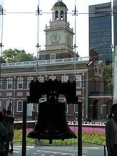
The Liberty Bell, previously called the State House Bell or Old State House Bell, is an iconic symbol of American independence, located in Philadelphia, Pennsylvania. Once placed in the steeple of the Pennsylvania State House, the bell today is located across the street in the Liberty Bell Center in Independence National Historical Park. The bell was commissioned in 1752 by the Pennsylvania Provincial Assembly from the London firm of Lester and Pack, and was cast with the lettering "Proclaim LIBERTY Throughout all the Land unto all the Inhabitants Thereof", a Biblical reference from the Book of Leviticus (25:10). The bell first cracked when rung after its arrival in Philadelphia, and was twice recast by local workmen John Pass and John Stow, whose last names appear on the bell. In its early years, the bell was used to summon lawmakers to legislative sessions and to alert citizens about public meetings and proclamations.

Independence Hall Historic building in Philadelphia, Pennsylvania, USA

Independence Hall is the building where both the United States Declaration of Independence and the United States Constitution were debated and adopted. It is now the centerpiece of the Independence National Historical Park in Philadelphia, Pennsylvania and is a UNESCO World Heritage Site.

Independence National Historical Park National historic site in Philadelphia, Pennsylvania, United States

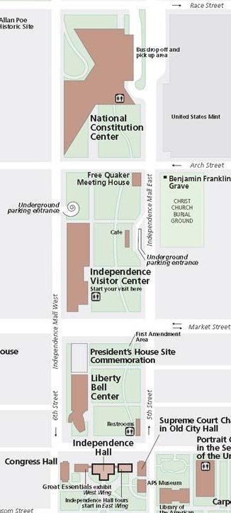
Independence National Historical Park is a federally protected historic district in Philadelphia, Pennsylvania, United States that preserves several sites associated with the American Revolution and the nation's founding history. Administered by the National Park Service, the 55-acre (22 ha) park comprises many of Philadelphia's most-visited historic sites within the Old City and Society Hill neighborhoods. The park has been nicknamed "America's most historic square mile" because of its abundance of historic landmarks.

Old City, Philadelphia United States historic place

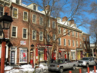
Old City is a historic neighborhood in Center City, Philadelphia, in the area near the Delaware River where William Penn and the Quakers first settled. To tourists, it is best known as the site of Independence Hall and its encompassing Independence National Historical Park, Elfreth's Alley, Carpenters' Hall, the Betsy Ross House, and many of Philadelphia's other historic sites.

Society Hill United States historic place

Society Hill is a historic neighborhood in Center City Philadelphia, Pennsylvania with a population of 6,215 as of the 2010 United States Census. Settled in the early 1680s, Society Hill is one of the oldest residential neighborhoods in Philadelphia. After urban decay developed between the late 19th and early 20th centuries, an urban renewal program began in the 1950s, restoring the area and its many historic buildings. Society Hill has since become one of the most expensive neighborhoods with the highest average income and second highest real estate values in Philadelphia. Society Hill's historic colonial architecture, along with intelligent planning and restoration efforts, led the American Planning Association to designate it, in 2008, as one of the great American neighborhoods and a good example of sustainable urban living.

Architecture of Philadelphia

The architecture of Philadelphia is a mix of historic and modern styles that reflect the city's history. The first European settlements appeared within the present day borders of Philadelphia, Pennsylvania in the 17th century with most structures being built from logs. By the 18th century brick structures had become common. Georgian and later Federal style buildings dominated much of the cityscape. In the first half of the 19th century, Greek revival appeared and flourished with architects such as William Strickland, John Haviland, and Thomas U. Walter. In the second half of the 19th century, Victorian architecture became popular with the city's most notable Victorian architect being Frank Furness.

Market Street (Philadelphia)

Market Street, originally known as High Street, is a major east–west street in Philadelphia, Pennsylvania. It is signed as Pennsylvania Route 3 between 38th Street and 15th Street. A short portion of the road continues west from Cobbs Creek Parkway to Delaware County.

Jacques-Henri-Auguste Gréber was a French architect specializing in landscape architecture and urban design. He was a strong proponent of the Beaux-Arts style and a contributor to the City Beautiful movement, particularly in Philadelphia and Ottawa.

The Residences at The Ritz-Carlton (Philadelphia)

The Residences at The Ritz-Carlton is a luxury residential skyscraper in Center City in Philadelphia, Pennsylvania. At 518 feet (158 m), the 48-story skyscraper is the twelfth-tallest building in Philadelphia, and the tallest residential tower in the city. The building was erected on the former site of One Meridian Plaza which was seriously damaged by a deadly fire in 1991. One Meridian Plaza was demolished in 1999 and the property was sold by E/R Partners to the Arden Group the next year. Development of the site by the Arden Group, which owns the adjacent Ritz-Carlton Philadelphia, was delayed for years as a result of a feud with rival developer Mariner Commercial Properties. Mariner owned the property 1441 Chestnut Street, which sits south of the Residences at The Ritz-Carlton site and intends to build its own residential tower. The feud began after Arden Group's lead partner Craig Spencer blocked approval of 1441 Chestnut Street because he felt the tower's design would be detrimental to the planned Residences at The Ritz-Carlton tower. This led to several years of dispute between the developers trying to block construction of each other's towers.

Rohm and Haas Corporate Headquarters United States historic place

The Rohm and Haas Corporate Headquarters in Philadelphia, Pennsylvania, United States was built as the headquarters for the former chemical manufacturing company Rohm and Haas. Completed in 1964, the building was the first private investment for the urban renewal of the Independence Mall area. Only two blocks from Independence Hall the building, designed by Pietro Belluschi and George M. Ewing Co., was lauded for its respect to the nearby park and historical buildings. Philadelphia's city planners praised the Rohm and Haas Corporate Headquarters as a standard for all redevelopment buildings.

Presidents House (Philadelphia)

The President's House in Philadelphia was the third U.S. Presidential Mansion. George Washington occupied it from November 27, 1790, to March 10, 1797; and John Adams occupied it from March 21, 1797, to May 30, 1800.

Provident Life & Trust Company

The Provident Life & Trust Company in Philadelphia, Pennsylvania, a demolished Victorian-era building by architect Frank Furness, is considered to have been one of his greatest works. A bank and insurance company founded in 1865 by members of the Society of Friends (Quakers), the Provident's L-shaped building had entrances at 407-09 Chestnut Street (bank) and 42 South 4th Street. The two wings were eventually consolidated into an office building at the northwest corner of 4th & Chestnut Streets.

St. Louis Gateway Mall

The Gateway Mall in St. Louis, Missouri is an open green space running linearly, one block wide, from the Gateway Arch at Memorial Drive to Union Station at 20th Street. Located in the city's downtown, it runs between Market Street and Chestnut Street.

Southern Boulevard Parkway is a landscaped segment of south Broad Street in Philadelphia, Pennsylvania connecting Marconi Plaza and FDR Park from Oregon Avenue at Broad Street southward five intersections to the gateway entrance of the Philadelphia Navy Yard. The parkway consists of the central median landscaped area including the bordering east and west tree lined sidewalks and various sized green spaces which separates opposing lanes of traffic, and roadway intersections. Broad Street itself is a historic city street and this landscaped segment is bordered by an urban residential townhome community and the entrance to the major venues of the South Philadelphia Sports Complex and Xfinity Live!, and the Philadelphia Navy Yard.

Liberty Bell Pavilion

The Liberty Bell Pavilion (demolished) was a building within Independence National Historical Park (INHP) in Philadelphia, Pennsylvania, that housed the Liberty Bell from January 1, 1976 to October 9, 2003. Designed by the architectural firm of Mitchell/Giurgola Associates to be the Bell's permanent home, it stood for only 30 years. The Bell is currently housed in a much larger building, the Liberty Bell Center, completed in 2003. The Pavilion was demolished in 2006.

Dilworth Park

Dilworth Park is a public park and open space along the western side of City Hall in Center City, Philadelphia. The one-half-acre (0.20 ha) park opened to the public on September 4, 2014.

Cherry Street (Philadelphia)

Cherry Street is a minor east-west street in Philadelphia, Pennsylvania that runs parallel to Race Street to the north and Arch Street to the south. It was not one of William Penn's original gridded streets from the 1680s, and began as an alleyway, bridging from one numbered street to the next. It is listed by name on the map in Birch's Views of Philadelphia (1800) – Race and Arch Streets are listed by their original names, "Sassafras" and "Mulberry." The earliest official use of the name Cherry Street was in 1809.

Chestnut Hill Friends Meeting

The Chestnut Hill Friends Meeting is a monthly meeting (congregation) of the Religious Society of Friends (Quakers). First meeting in 1924, they were the first "United" monthly meeting, reconciling Philadelphia Quakers after the Hicksite/Orthodox schism of 1827. The original Meeting House, built in 1931, was located at 100 E. Mermaid Lane in the Chestnut Hill neighborhood of Philadelphia, Pennsylvania. It was replaced in 2012-2013 by the current meeting house, located at 20 E. Mermaid Lane, which incorporates a Skyspace designed by Quaker light artist James Turrell, the second such installation to be incorporated into a working religious space. The new Quaker meeting house is the first to be built in Philadelphia in eighty years.

Los Angeles Mall

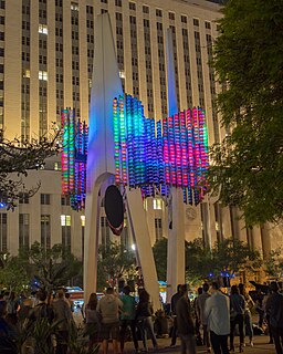
The Los Angeles Mall is a small shopping center and series of plazas at the Los Angeles Civic Center, between Main and Los Angeles Streets on the north and south sides of Temple Street, connected by both a pedestrian bridge and a tunnel. It features Joseph Young's sculpture Triforium, a colorful sculpture unveiled in 1975, which has with 1,500 blown-glass prisms synchronized to an electronic glass bell carillon. The mall opened in 1974 and includes a four-level parking garage with 2,400 spaces. It stands on the site of what once were some of the oldest commercial blocks in the city that were demolished in the 1940s and 1950s.

References

  1. Inga Saffron, "Changing skyline: Adding coffee to the culture," The Philadelphia Inquirer, July 4, 2008.
  2. "Independence Hall". TeachingAmericanHistory.org. Retrieved June 22, 2015.
  3. 1 2 3 4 "Summary of INHP and Independence Mall Evolution". Bryn Mawr College. Archived from the original on November 28, 2012. Retrieved June 24, 2015.
  4. 1 2 3 4 5 "Independence Mall". The Cultural Landscape Foundation. Retrieved June 24, 2015.
  5. "A Short History of Independence Hall Mall". Revisit Products Blog. Archived from the original on June 24, 2015. Retrieved June 23, 2015.
  6. Greiff, Constance M. (1987). Independence: The Creation of a National Park. Philadelphia: University of Pennsylvania Press. pp. 208–214. ISBN   978-0812280470. Greiff, pp. 208–14.
  7. Medina, Regina (November 15, 2005). "Historic Changes to Independence Mall". Philadelphia Daily News. Philadelphia, Pennsylvania. Retrieved June 24, 2015.
  8. "People's Plaza". UShistory.org. Retrieved June 24, 2015. 'People's Plaza features the First Amendment, and provides electricity and other needs for groups to use the space for public assembly.'

Coordinates: 39°57′03″N75°08′58″W / 39.9508°N 75.1495°W / 39.9508; -75.1495