Ingatestone and Fryerning

Last updated
Ingatestone and Fryerning
Civil parish
I&FPC.jpg
Coordinates: 51°40′35″N0°21′53″E / 51.67639°N 0.36472°E / 51.67639; 0.36472 Coordinates: 51°40′35″N0°21′53″E / 51.67639°N 0.36472°E / 51.67639; 0.36472
CountryEngland
Primary council Brentwood
County Essex
Region East of England
StatusParish
Main settlements Ingatestone, Fryerning
Government
  TypeParish Council
   UK Parliament Brentwood and Ongar
Population
 (2011)
  Total4,787
Website Ingatestone and Fryerning Parish Council
Ingatestone Sign Ingatestone Sign.jpg
Ingatestone Sign

Ingatestone and Fryerning is a civil parish [1] in the Brentwood borough of Essex, England.

Contents

The parish includes the villages of Ingatestone and Fryerning, and covers an area of 3,917 acres (15.85 km2).

History

The civil parish was formed on 24 March 1889 by merging the ancient parishes of Ingatestone and Fryerning. [2] The two parishes were oddly shaped, with the parish of Fryerning running from the north-west to the south-east of Ingatestone, bisecting the other parish.

Unusually, most of the village of Ingatestone was in the parish of Fryerning, and therefore not in the parish of Ingatestone.

On 1 October 1950 some land around Handley Green was moved to the parish of Margaretting, and at the same time an area to the south-west of Margaretting Hall was added to Ingatestone and Fryerning. [3]

Parish council

A year after the passing of the Local Government Act 1894, Ingatestone and Fryerning Parish Council was formed. Since then, the council has had thirteen different chairmen.

The parish council today has fifteen directly-elected members who each serve for four years. There are no wards – all councillors are elected by the entire parish – and all fifteen are elected at the same time. The most recent elections were held in May 2011 and were contested by twenty candidates.

The entire parish council meets monthly, although there are also meetings of three committees: Policy and Resources, Churchyards and Environment, and Planning. The Planning Committee meets once a fortnight, the other two committees once a month.

The parish council raises a precept on the local Council Tax, and has an annual income of around £120,000. The council has offices and directly employs three members of staff.

Activities

The parish council is responsible for a range of local amenities with the villages:

Related Research Articles

<span class="mw-page-title-main">Parish council (England)</span> Elected corporate bodies responsible for local government in English civil parishes

Parish councils are civil local authorities found in England which are the lowest tier of local government. They are elected corporate bodies, with variable tax raising powers, and they carry out beneficial public activities in geographical areas known as civil parishes. There are about 9,000 parish and town councils in England, and over 16 million people live in communities served by them. Parish councils may be known by different styles, they may resolve to call themselves a town council, village council, community council, neighbourhood council, or if the parish has city status, it may call itself a city council. However their powers and duties are the same whatever name they carry.

<span class="mw-page-title-main">Verwood</span> Human settlement in England

Verwood is a town and civil parish in eastern Dorset, England. The town lies 10 miles (16 km) north of Bournemouth and 13 miles (21 km) north east of Poole as the crow flies. The civil parish comprises the town of Verwood together with the extended village of Three Legged Cross, and has a population of 15,170 according to latest figures (2014) from Dorset County Council. Verwood is the largest town in Dorset without an upper school.

<span class="mw-page-title-main">Polegate</span> Town in East Sussex, England

Polegate is a town and civil parish in the Wealden District of East Sussex, England, United Kingdom. It is located five miles (8 km) north of the seaside resort of Eastbourne and is part of the greater area of that town. Although once a railway settlement, its rail links were closed as part of the Beeching cuts. The 2011 census put the civil parish of Polegate at a population of 8,586, with 41.2% aged 65 and over.

<span class="mw-page-title-main">Civil parish</span> Territorial designation and lowest tier of local government in England

In England, a civil parish is a type of administrative parish used for local government. It is a territorial designation which is the lowest tier of local government below districts and counties, or their combined form, the unitary authority. Civil parishes can trace their origin to the ancient system of ecclesiastical parishes, which historically played a role in both secular and religious administration. Civil and religious parishes were formally differentiated in the 19th century and are now entirely separate. Civil parishes in their modern form came into being through the Local Government Act 1894, which established elected parish councils to take on the secular functions of the parish vestry.

<span class="mw-page-title-main">Ingatestone</span> Commuter village in Essex, England

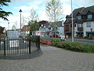
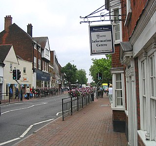
Ingatestone is a village and former civil parish in Essex, England, with a population of 5,365 inhabitants according to the 2011 census. Just north lies the village of Fryerning, the two forming now the parish of Ingatestone and Fryerning. Ingatestone lies in the Metropolitan Green Belt 20 miles north-east of London. Its built-up area straddles the A12 trunk road and the Great Eastern Main Railway Line. It has become an affluent commuter village, seen as one of the UK's best places to live by the Sunday Times in 2020.

<span class="mw-page-title-main">Hoo St Werburgh</span> Human settlement in England

Hoo St Werburgh, commonly known as Hoo, is a large village and civil parish in the Medway district of Kent, England. It is one of several villages on the Hoo Peninsula to bear the name Hoo, a Saxon word believed to mean "spur of land" or to refer to the "distinct heel-shape of the ridge of hills" through the settlement. Hoo features in Domesday Book, and had a population of 7,356 at the 2001 census, rising to 8,945 at the 2011 census. The civil parish includes Chattenden to the west.

Sutton or Sutton-in-the-Isle is village and civil parish in the county of Cambridgeshire in England, near the city of Ely. The "in-the-Isle" suffix refers to the fact that the village is part of the Isle of Ely, once an island in the Fens and also an administrative county until 1965.

<span class="mw-page-title-main">Kingston Seymour</span> Human settlement in England

Kingston Seymour is a small village and civil parish with royal status in Somerset, England. It is situated within the unitary authority of North Somerset, between Clevedon and Weston-super-Mare on the North Somerset Levels. The parish has a population of 388.

<span class="mw-page-title-main">Local Council (Uganda)</span> Form of local elected government within the districts of Uganda

A Local Council (LC) is a form of local elected government within the districts of Uganda.

<span class="mw-page-title-main">Whyteleafe</span> Human settlement in England

Whyteleafe is a village in the district of Tandridge, Surrey, England, with a few streets falling inside the London Borough of Croydon. The village, in a dry valley of the North Downs, has three railway stations. Neighbouring villages and towns include Woldingham, Caterham, Coulsdon, Warlingham, and Kenley. To the west are Kenley Aerodrome, Kenley Common, Coxes Wood, and Blize Wood. To the east are Riddlesdown, the Dobbin and Marden Park.

<span class="mw-page-title-main">Fryerning</span> Human settlement in England

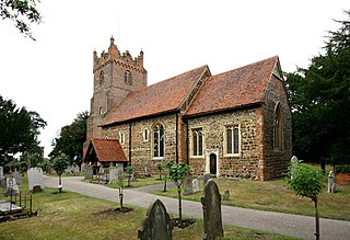
Fryerning is a small village and former civil parish, now in the parish of Ingatestone and Fryerning, which is situated approximately 1+12 miles (2.4 km) north of Ingatestone in Essex, England. The parish church of St. Mary the Virgin, on Blackmore Road, dates back from the 11th century, with a 15th-century brick tower. It has a memorial stained glass window to the murdered politician Airey Neave, which was unveiled by his cousin Penelope in 1985. An ancient English Yew, found to the west of the church and is over a millennium old, is thought to be one of Essex's oldest trees. In 1881, the parish had a population of 704.

<span class="mw-page-title-main">Mountnessing</span> Human settlement in England

Mountnessing is a village and civil parish in the Borough of Brentwood in south Essex, England. It is situated to the north-east of Brentwood, south-west of Ingatestone. A large proportion of the houses are situated on the Roman Road between Brentwood and Ingatestone. The village is approximately equidistant between the two closest railway stations of Shenfield and Ingatestone.

<span class="mw-page-title-main">Caddington</span> Human settlement in England

Caddington is a village and civil parish in the Central Bedfordshire district of Bedfordshire, England. It is between the Luton/Dunstable urban area, and Hertfordshire.

<span class="mw-page-title-main">Chelmsford (UK Parliament constituency)</span> Parliamentary constituency in the United Kingdom (1885 to 1997 and 2010 onwards)

Chelmsford is a constituency in Essex represented in the House of Commons of the UK Parliament since 2017 by Vicky Ford of the Conservative Party. In September 2022, she was appointed by Prime Minister Liz Truss as Minister of State for Development in the Foreign, Commonwealth and Development Office.

<span class="mw-page-title-main">Twineham</span> Village in England

Twineham is a village and civil parish in the Mid Sussex District of West Sussex, England. It is located eight kilometres to the west of Burgess Hill. The civil parish covers an area of 784 hectares In the 2001 census 271 people lived in 100 households, of whom 139 were economically active. The 2011 Census population was 306.

<span class="mw-page-title-main">Maulden</span> Human settlement in England

Maulden is a village and civil parish located in the county of Bedfordshire. The village is located 1.5 miles east of Ampthill and about 8 miles (13 km) south of Bedford. It has about 1,250 homes and 3130 residents.

<span class="mw-page-title-main">Cheddleton</span> Village in Staffordshire, England

Cheddleton is an ancient parish and village in the Staffordshire Moorlands, near to the town of Leek, England.

<span class="mw-page-title-main">Brentwood, Essex</span> Human settlement in England

Brentwood is a town in the Borough of Brentwood, in the county of Essex in the East of England. It is in the London commuter belt, situated 20 miles (30 km) east-north-east of Charing Cross and close by the M25 motorway. In 2017, the population of the town was estimated to be 54,885.

Chelmsford Rural District was a local government district in Essex, England from 1894 to 1974. It surrounded, but did not include, the town of Chelmsford; which formed a municipal borough.

Margaretting is a village and civil parish in the Chelmsford district, in the county of Essex, England. The population of the village taken at the 2011 Census was 847.

References

  1. "Ingatestone and Fryerning Parish" . Retrieved 3 January 2023.
  2. "Chelmsford Registration District". UKBMD. Retrieved 26 December 2021.
  3. "Relationships and changes Ingatestone and Fryerning CP through time". A Vision of Britain through Time. Retrieved 26 December 2021.