Ingatestone appeared in Saxon times[1][2] on the Essex Great Road (now the A12) between the Roman towns of Londinium (London) and Camulodunum (Colchester).[3] The name means "Ing at the Stone", the suffix distinguishing it from nearby settlements that also formed part of the manor of Ing. It is first recorded in 1283 as Gynges atte Ston.[4] It appears as "Inge atte Stone" in 1433. [5]
Stone is not prevalent in the local geology. The village stone, deposited by glacial action, is unusual for the area. A large Sarsen stone can still be seen, split into three, with one piece by the west door of the St Edmund and St Mary's parish church and one each side of the entrance to Fryerning Lane.
By the time of the Domesday Book in 1086, Fryerning and Ingatestone (Inga) were assigned to the Hundred of Chelmsford, as part of the land of St Mary of Barking with a value of 60 shillings (£3), held by Robert Gernon in demesne.[6]
By the 18th century Ingatestone had become a coaching centre, but the advent of the railway saw its importance decrease, along with the traffic on the Essex Great Road. By 1881 the parish had a population of 926[7] and on 24 March 1889, the parishes of Ingatestone and Fryerning merged to form Ingatestone and Fryerning,[8] encompassing an area of almost 4,000 acres (16km2).[3] Ingatestone grew further in the 20th century as commuters moved in, attracted by the surrounding countryside.
Plans to bypass the narrow Roman road through the village were first drawn up before the Second World War, but construction of a dual-carriageway bypass did not begin until 1958.[9] Further dual-carriageway sections of the A12 trunk road were added in the 1960s, to bypass Brentwood and Chelmsford.
Geology
Ingatestone lies just to the north of the southernmost limit of glaciation in the British Isles. Surface deposits over much of the area consist of boulder clay and it is only to the north-east that there are more sandy deposits. Geologist Ciara Lovatt conducted several rock mineral experiments on deposits within Ingatestone in the 1980s. The glacial deposits overlie London clay, which can be seen occasionally in the bed of the River Wid and its tributaries.
The geology of the area is responsible for the landscape and the character of farming in surrounding area. Crop farming is the typical use of boulder clay lands. The sandy deposits to the north-east of Ingatestone are a contributory factor in the greater incidence of woodland and non-arable land in this area.
Ingatestone Hall has been the home of the Petre family since the 16th century, who reside there to this day. The location was chosen due to the similarity of the village's Latin name with their own. [citation needed] A tomb monument to members of the family is located in the parish church of St Edmund and St Mary's.
The hall is currently open as a tourist attraction. It largely retains its Tudor appearance following restoration carried out between 1915 and 1937, and is set in formal gardens surrounded by eleven acres of grounds. Inside is a range of antique furniture, paintings and other historical artefacts. Queen Elizabeth I spent several nights at the hall on her Royal Progress of 1561. St. John Payne, one of the Forty Martyrs of England and Wales, resided at Ingatestone Hall in the late 16th century as chaplain and steward for Lady Petre. He was martyred at Chelmsford in 1582. The smallpoxinoculator, Daniel Sutton, made his base on Ingatestone High Street in Brandiston House, and carried out much of his work here.
Economy
Ingatestone has over a hundred shops and businesses. Among the retail outlets there are two small supermarkets (Budgens and Coop) as well as many retail and industrial shops.[10]
The Bell public house
There are two public houses are both in the High Street. The tiny Star Inn is the older, dating back to the 15th century. It features low-beamed ceilings and a large, open log fire. The Bell is a conventional pub in a traditional style, with a substantial Elizabethan brick fireplace in the lounge bar. A third pub, The Crown, was shut after a police raid in 2011 discovered cannabis being grown there. It has now become the Crown Mews development.
Amenities
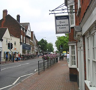
High Street, Ingatestone
Ingatestone has over 40 clubs and societies, ranging from arts and sports clubs to charitable societies. They include the Ingatestone and Fryerning Dramatic Club, founded in 1947, the Ingatestone Musical and Operetta Group, founded in 1970, the Ingatestone Choral Society, established in 1948, and the Ingatestone and Horticultural Society formed in 1963, which is affiliated to the Royal Horticultural Society. There is also a Community Association, which meets at a large hall in High Street. Other amenities include a recreation ground, a sports field, and bowls and tennis clubs.[3]
The Rotary Club is active and sponsored a war memorial in 2005 to mark the movement's centenary. The memorial, in the village's Anglican churchyard, is dedicated to the memory of the men of Ingatestone who served and fell in the two world wars.
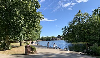
There are two parks. One is currently called Seymour Field, having been renamed after 'Skip' Seymour, a former headteacher of a local school, in 1977. It was previously known as Transport Meadow, having been donated to the village by the Ministry of Transport after the construction of the first A12 bypass in 1959. The other park is the Fairfield, a historic site of village fairs, which is privately owned by the Petre family and leased to the parish council.
The local community comes together for key annual events, including a Victorian-themed Christmas evening in the High Street and a free annual firework display on the Fairfield on New Year's Eve.
Ingatestone has a community magazine called the Ingatestone Journal, delivered to residents of Ingatestone, Stock and Margaretting, it covers local issues and events, and allows businesses to advertise their services.
The novelist and musician Alice Diehl lived in Ingatestone shortly before her death in 1912.[11] Sound poet and musician Henri Chopin lived in an old house by the railway station in the 1970s and 1980s. The actress Sarah Miles and her director brother, Christopher Miles, were born in Ingatestone. The noted naturalist and entomologist Sheffield Airey Neave lived in the village following retirement. Historian and author Ian Yearsley was born in Ingatestone.
Ingatestone has two conservation areas, one covering the railway station and Station Lane, the other protecting the central shopping area of High Street.
Education
Ingatestone has three schools:
Ingatestone Infant School, teaching children between the ages of four and seven.
Ingatestone and Fryerning Church Of England Voluntary Aided Junior School, teaching children between the ages of seven and eleven from years 3 to 6.
The Anglo European School, a self-governing state school for children aged from eleven to nineteen, specialising in language study. It was the first state school in Britain to offer the International Baccalaureate Diploma[3] and the first to become a Language College. The school has a capacity of 1307 students, chaired by headteacher Jody Gee.
Sport
Ingatestone and Fryerning Cricket Club plays in Division 2 and 6 of the T.Rippon Mid-Essex League and celebrated their 160th anniversary in 2018. The village also has two football teams: Redstones Football Club and Stones Athletic Youth Football Club.
The route of the A12 trunk road once passed through the centre of the village, but has since been bypassed. It provides direct access to East London, Chelmsford, Colchester, Ipswich, Harwich and Lowestoft; it also connects to the M25 motorway7 miles (11km) away.
The village is served by First Essex's route 351, which provides regular services to Chelmsford, Brentwood and Warley. School services are operated by First Essex and NIBS Buses.[13]
Related Research Articles
Gidea Park is a neighbourhood in the east of Romford in the London Borough of Havering, south-east England. Predominantly an affluent and residential area, it was historically located in the county of Essex. It saw significant expansion in the early 20th century, with exhibitions of housing and town planning and the construction of a railway station on the main line out from London Liverpool Street station.
The A12 is a major road in Eastern England. It runs north-east/south-west between London and the coastal town of Lowestoft in the north-eastern corner of Suffolk, following a similar route to the Great Eastern Main Line until Ipswich. A section of the road between Lowestoft and Great Yarmouth became part of the A47 in 2017. Between the junctions with the M25 and the A14, the A12 forms part of the unsigned Euroroute E30. Unlike most A roads, this section of the A12, together with the A14 and the A55, has junction numbers as if it were a motorway.
The City of Chelmsford is a local government district with borough and city status in Essex, England. It is named after its main settlement, Chelmsford, which is also the county town of Essex. As well as the settlement of Chelmsford itself, the district also includes the surrounding rural area and the town of South Woodham Ferrers.
The Borough of Brentwood is a local government district with borough status in Essex, England. The borough is named after its main town of Brentwood, where the council is based; it includes several villages and the surrounding rural area.
Boreham is a village and civil parish in Essex, England. The parish is in the City of Chelmsford and Chelmsford Parliament constituency. The village is approximately 3.7 miles (6.0 km) northeast of the county town of Chelmsford.
John Patrick Lionel Petre, 18th Baron Petre, is a British peer and landowner who was the Lord Lieutenant of Essex, succeeding Robin Neville, 10th Baron Braybrooke in October 2002. He is the 18th Baron of the Petre family, an old recusant family.
Shenfield is a town in the Borough of Brentwood in Essex, England. In 2020, the ward was estimated to have a population of 5,396.
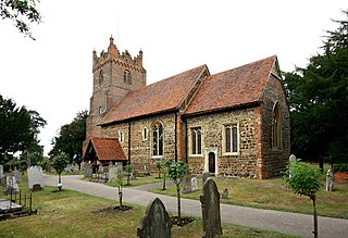
Fryerning is a small village and former civil parish, now in the parish of Ingatestone and Fryerning, in the Brentwood district, in the county of Essex, England. It is situated approximately 2 miles (3.2 km) north of Ingatestone. The parish church of St. Mary the Virgin, on Blackmore Road, dates back from the 11th century, with a 15th-century brick tower. It has a memorial stained glass window to the murdered politician Airey Neave, which was unveiled by his cousin Penelope in 1985. An ancient English Yew, found to the west of the church and is over a millennium old, is thought to be one of Essex's oldest trees. In 1881, the parish had a population of 704.
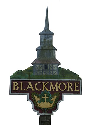
Blackmore is a village in Essex, England. It is located approximately 3 miles (5 km) east of Chipping Ongar and 4 miles (7 km) north of Brentwood. The village is in the parish of Blackmore, Hook End and Wyatts Green in the Brentwood district and the parliamentary constituency of Brentwood & Ongar. In 2018 it had an estimated population of 826.
Mountnessing is a village and civil parish in the Borough of Brentwood in south Essex, England. It is situated to the north-east of Brentwood, south-west of Ingatestone. A large proportion of the houses are situated on the Roman Road between Brentwood and Ingatestone. The village is approximately equidistant between the two closest railway stations of Shenfield and Ingatestone. It Main Attractions is the Mountnessing Windmill and the local pub opposite called the Prince of Wales Pub.
Chelmsford is a constituency in Essex represented in the House of Commons of the UK Parliament since 2017 by Vicky Ford of the Conservative Party.
Kelvedon is a village and civil parish in the Braintree District of Essex in England, between Chelmsford and Colchester. It had a population of 4,717 in 2001, reducing to 3,587 at the 2011 Census. It is now home to several businesses including Knight Group and Lysanda. Brockwell Meadows Local Nature Reserve is south-east of the village between a housing estate and the River Blackwater.
Ingatestone railway station is on the Great Eastern Main Line in the East of England, serving the village of Ingatestone, Essex. It is 23 miles 50 chains (38.0 km) down the line from London Liverpool Street and is situated between Shenfield to the west and Chelmsford to the east. Its three-letter station code is INT.
Stock is a village and civil parish in south Essex, England. It is about 6 miles (10 km) south of Chelmsford, the county town. The village is in the borough of Chelmsford and in the parliamentary constituency of Maldon.
Ingatestone and Fryerning is a civil parish in the Brentwood borough of Essex, England.
Brentwood is a town in Essex, England, in the London commuter belt 20 miles (30 km) north-east of Charing Cross and close to the M25 motorway. The population of the built-up area was 55,340 in 2021.
Chelmsford Rural District was a local government district in Essex, England from 1894 to 1974. It surrounded, but did not include, the town of Chelmsford; which formed a municipal borough.
Margaretting is a village and civil parish in the Chelmsford district, in the county of Essex, England. The population of the village taken at the 2011 Census was 847.
Heybridge is a settlement in the civil parish of Ingatestone and Fryerning, in the Brentwood borough of Essex, England, contiguous with the village of Ingatestone. The main development comprises a mixture of houses and bungalows which were built in 1954 on land owned by the Coal Board and an area of local authority housing.
Our Lady Immaculate Church is a Roman Catholic Parish church in Chelmsford, Essex, England. It was founded in 1845, opened in 1847 and designed by Joseph John Scoles. It is situated on New London Road, next to Our Lady Immaculate Primary School, close to the junction with Anchor Street, in the city centre.
This page is based on this Wikipedia article Text is available under the CC BY-SA 4.0 license; additional terms may apply. Images, videos and audio are available under their respective licenses.