Irthlingborough Lakes and Meadows

Last updated
Irthlingborough Lakes and Meadows

Irthlingborough Lakes and Meadows - Corner Lake in Winter.jpg

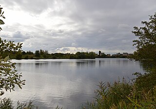
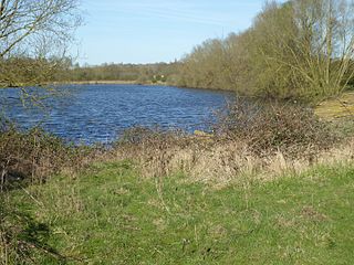
View looking North across Corner Lake
Northamptonshire UK location map.svg
Red pog.svg
shown within Northamptonshire
Location Irthlingborough, Northamptonshire
Coordinates 52°19′10.92″N0°36′10.44″W / 52.3197000°N 0.6029000°W / 52.3197000; -0.6029000 Coordinates: 52°19′10.92″N0°36′10.44″W / 52.3197000°N 0.6029000°W / 52.3197000; -0.6029000
Area 117 hectares (290 acres)
Created 2012
Operated by Wildlife Trust for Bedfordshire, Cambridgeshire and Northamptonshire
Status Open all year
Website http://www.irthlingboroughlakesandmeadows.org

Irthlingborough Lakes and Meadows (grid reference SP953699 ) is a 117-hectare (290-acre) nature reserve in Northamptonshire, owned and managed by the Wildlife Trust for Bedfordshire, Cambridgeshire and Northamptonshire. [1] The character of the reserve is defined by flooded gravel pits and wet grassland, providing an excellent habitat for large variety of wetland flora and fauna.

Ordnance Survey National Grid System of geographic grid references used in Great Britain

The Ordnance Survey National Grid reference system is a system of geographic grid references used in Great Britain, distinct from latitude and longitude. It is often called British National Grid (BNG).

Northamptonshire County of England

Northamptonshire, archaically known as the County of Northampton, is a county in the East Midlands of England. In 2015 it had a population of 723,000. The county is administered by Northamptonshire County Council and by seven non-metropolitan district councils. It is known as "The Rose of the Shires".

Wildlife Trust for Bedfordshire, Cambridgeshire and Northamptonshire registered charity which manages 126 nature reserves covering 3,945 hectares across Bedfordshire, Cambridgeshire and Northamptonshire in the United Kingdom

The Wildlife Trust for Bedfordshire, Cambridgeshire and Northamptonshire (WTBCN) is a registered charity which manages 126 nature reserves covering 3,945 hectares. It has over 35,000 members, and 95% of people in Bedfordshire, Cambridgeshire and Northamptonshire live within five miles of a reserve. In the year to 31 March 2016 it employed 105 people and had an income of £5.1 million. It aims to conserve wildlife, inspire people to take action for wildlife, offer advice and share knowledge. The WTBCN is one of 36 wildlife trusts covering England, and 47 covering the whole of the United Kingdom.

Contents

The site forms part of the larger Upper Nene Valley Gravel Pits Site of Special Scientific Interest (SSSI) and Special Protection Area. [2]

Upper Nene Valley Gravel Pits

Upper Nene Valley Gravel Pits is a 1,382.4 hectare biological Site of Special Scientific Interest in a chain of flooded gravel pits along 35 kilometres of the valley of the River Nene between Northampton and Thorpe Waterville in Northamptonshire. It is a Ramsar wetland site of international importance, a Special Protection Area under the European Communities Birds Directive and part of the Nene Valley Nature Improvement Area. It is also part of the River Nene Regional Park. Two areas are managed by the Wildlife Trust for Bedfordshire, Cambridgeshire and Northamptonshire, Summer Leys and Titchmarsh Nature Reserve.

Site of Special Scientific Interest Conservation designation denoting a protected area in the United Kingdom

A Site of Special Scientific Interest (SSSI) in Great Britain or an Area of Special Scientific Interest (ASSI) in the Isle of Man and Northern Ireland is a conservation designation denoting a protected area in the United Kingdom and Isle of Man. SSSI/ASSIs are the basic building block of site-based nature conservation legislation and most other legal nature/geological conservation designations in the United Kingdom are based upon them, including national nature reserves, Ramsar sites, Special Protection Areas, and Special Areas of Conservation. The acronym "SSSI" is often pronounced "triple-S I".

A Special Protection Area (SPA) is a designation under the European Union Directive on the Conservation of Wild Birds. Under the Directive, Member States of the European Union (EU) have a duty to safeguard the habitats of migratory birds and certain particularly threatened birds. Together with Special Areas of Conservation (SACs), the SPAs form a network of protected sites across the EU, called Natura 2000. Each SPA has an EU code – for example the North Norfolk Coast SPA has the code UK9009031.

It is situated in close proximity to several other Wildlife Trust nature reserves, such as Higham Ferrers Pits, Wilson's Pits and Ditchford Lakes and Meadows, significantly improving the benefit for wildlife by creating joined-up protected landscapes. It is adjacent to Stanwick Lakes, a reserve managed by the Rockingham Forest Trust.

History

Originally water meadows and agricultural fields straddling both sides of the River Nene, the site has been transformed significantly in recent history. The first such intervention was the construction of the Northampton to Peterborough Railway, which opened in 1845. During its construction, ironstone was discovered in the Nene Valley.

A water-meadow is an area of grassland subject to controlled irrigation to increase agricultural productivity. Water-meadows were mainly used in Europe from the 16th to the early 20th centuries. Working water-meadows have now largely disappeared, but the field patterns and water channels of derelict water-meadows remain common in areas where they were used, such as parts of Northern Italy, Switzerland and England. Derelict water-meadows are often of importance as wetland wildlife habitats.

River Nene river in the east of England

The River Nene is a river in the east of England that rises from three sources in Northamptonshire. The tidal river is about 100 miles (160 km) long, about 3.7 miles (6.0 km) of which forms the border between Cambridgeshire and Norfolk. It is the tenth-longest river in the United Kingdom, and is navigable for 88 miles (142 km), from Northampton to The Wash.

The Northampton and Peterborough Railway was an early railway promoted by the London and Birmingham Railway to run from a junction at Blisworth to Northampton and Peterborough. The Northampton and Peterborough Railway Act received the Royal Assent in 1843 and the line opened in 1845. In 1846, it became part of the London and North Western Railway (LNWR). The LNWR became a constituent of the London, Midland and Scottish Railway (LMS) when the railways of Great Britain were merged in the grouping of 1923. In 1948, the LMS became part of the publicly owned British Railways. Regular passenger services ceased in 1964 and the line closed completely in 1972. A part of it has since been reopened as the Nene Valley Railway heritage line.

Following the outbreak of World War I, in 1916, the Ebbw Vale Mining Company commenced operations, producing around 6000 tons of ore per week. [3]

World War I 1914–1918 global war originating in Europe

World War I, also known as the First World War or the Great War, was a global war originating in Europe that lasted from 28 July 1914 to 11 November 1918. Contemporaneously described as "the war to end all wars", it led to the mobilisation of more than 70 million military personnel, including 60 million Europeans, making it one of the largest wars in history. It is also one of the deadliest conflicts in history, with an estimated nine million combatants and seven million civilian deaths as a direct result of the war, while resulting genocides and the 1918 influenza pandemic caused another 50 to 100 million deaths worldwide.

The most recent and most impactful intervention on the landscape began in the 1970s, with the large scale extraction of sand and gravel along the Nene Valley. An electric conveyor belt was constructed following the now disused railway line to transport the material to a processing plant at nearby Stanwick Lakes. By the time operations ceased in 2002, more than 1.5 million tons of aggregate had been extracted from the area. The pits were then allowed to flood, creating the present day series of lakes and channels. [4]

Construction aggregate broad category of coarse particulate material used in construction

Construction aggregate, or simply "aggregate", is a broad category of coarse to medium grained particulate material used in construction, including sand, gravel, crushed stone, slag, recycled concrete and geosynthetic aggregates. Aggregates are the most mined materials in the world. Aggregates are a component of composite materials such as concrete and asphalt concrete; the aggregate serves as reinforcement to add strength to the overall composite material. Due to the relatively high hydraulic conductivity value as compared to most soils, aggregates are widely used in drainage applications such as foundation and French drains, septic drain fields, retaining wall drains, and roadside edge drains. Aggregates are also used as base material under foundations, roads, and railroads. In other words, aggregates are used as a stable foundation or road/rail base with predictable, uniform properties, or as a low-cost extender that binds with more expensive cement or asphalt to form concrete.

In 2012, with help from a Heritage Lottery Fund grant and public donations, the Wildlife Trust for Bedfordshire, Cambridgeshire and Northamptonshire purchased the neglected site. It is now the focus of some of the trust's most important work as part of the Nene Valley Living Landscapes conservation scheme. To maximize the reserve's benefit for wildlife and biodiversity, numerous improvement works have been undertaken. These include the creation of new islands and removal of willow and electricity pylons. [5]

Wildlife

The Nene Valley is one of the most important wetlands in England and has gained international recognition for its significance as a stop-over for thousands of wildfowl and waders that visit during the winter. The quantity and variety of birdlife varies greatly with the seasons, with the following overwintering at the site: [1]

Surrounding the river and lakes, fragments of now rare meadow survive. These provide ideal conditions for meadowsweet, great burnet and common spotted orchid.

Management

A variety of different management techniques are being used to maintain and bolster the reserve's benefit for wildlife. Within the wetland areas, ditches are periodically cleared, scrub is removed and trees copsed to maintain the open nature of the gravel pits. The grassland is grazed and cut on rotation to maintain a mosaic of grassland scrub habitats.

Related Research Articles

Great Fen nature reserve in the United Kingdom

The Great Fen is a habitat restoration project being undertaken on The Fens in the county of Cambridgeshire in the United Kingdom. It is one of the largest restoration projects in the country, and aims to create a 3,700 hectare wetland and aims to connect Woodwalton Fen National Nature Reserve (NNR), Holme Fen NNR and other nature reserves to create a larger site with conservation benefits for wildlife and socio-economic benefits for people.

Barton Gravel Pit nature reserve in the United Kingdom

Barton Gravel Pit is a 1.1 hectare nature reserve east of Barton-le-Clay in Bedfordshire. It is managed by the Wildlife Trust for Bedfordshire, Cambridgeshire and Northamptonshire.

Cople Pits nature reserve in the United Kingdom

Cople Pits is a two hectare nature reserve in Cople in Bedfordshire. It is managed by the Wildlife Trust for Bedfordshire, Cambridgeshire and Northamptonshire.

Felmersham Gravel Pits nature reserve in the United Kingdom

Felmersham Gravel Pits is a 21.6 hectare Site of Special Scientific Interest between the villages of Felmersham and Sharnbrook in Bedfordshire. It was notified under Section 28 of the Wildlife and Countryside Act 1981 in 1986 and the local planning authority is Bedford Borough Council. The site is managed by the Wildlife Trust for Bedfordshire, Cambridgeshire and Northamptonshire.

Eye Green Local Nature Reserve

Eye Green Local Nature Reserve is a 12 hectare Local Nature Reserve in Eye Green in Cambridgeshire. It was managed by the Wildlife Trust for Bedfordshire, Cambridgeshire and Northamptonshire until September 2016, when management was transferred to its owner, Peterborough City Council. A small part is also in the Eye Gravel Pit geological Site of Special Scientific Interest.

Summer Leys Local nature reserve in Northamptonshire, England

Summer Leys is a local nature reserve at Wollaston in the Upper Nene Valley, in Northamptonshire, England. It is owned by the Wildlife Trust for Bedfordshire, Cambridgeshire and Northamptonshire.

Rothwell Gullet nature reserve in the United Kingdom

Rothwell Gullet is a 1.6-hectare (4.0-acre) nature reserve near Rothwell, Northamptonshire. It is owned and managed by the Wildlife Trust for Bedfordshire, Cambridgeshire and Northamptonshire.

Godmanchester Nature Reserve nature reserve in the United Kingdom

Godmanchester Nature Reserve is a 59 hectare nature reserve in Godmanchester in Cambridgeshire. It is managed by the Wildlife Trust for Bedfordshire, Cambridgeshire and Northamptonshire.

Kingsthorpe Meadow nature reserve in the United Kingdom

Kingsthorpe Meadow is a 14.4 hectare Local Nature Reserve in Northampton. It is owned by Northampton Borough Council and managed by the Wildlife Trust for Bedfordshire, Cambridgeshire and Northamptonshire.

Titchmarsh Nature Reserve nature reserve in the United Kingdom

Titchmarsh Nature Reserve is a 72.7 hectare Local Nature Reserve north of Thrapston in East Northamptonshire. It is owned and managed by the Wildlife Trust for Bedfordshire, Cambridgeshire and Northamptonshire. It is part of the Upper Nene Valley Gravel Pits Site of Special Scientific Interest.

Ditchford Lakes and Meadows nature reserve in the United Kingdom

Ditchford Lakes and Meadows is a 31.1 hectare nature reserve Northamptonshire. It is managed by the Wildlife Trust for Bedfordshire, Cambridgeshire and Northamptonshire. It is part of the Upper Nene Valley Gravel Pits Site of Special Scientific Interest, Ramsar wetland site of international importance, and Special Protection Area under the European Communities Birds Directive.

Stortons Pits nature reserve in the United Kingdom

Storton's Pits is a 21.9 hectare Local Nature Reserve in Northampton. It is managed by the Wildlife Trust for Bedfordshire, Cambridgeshire and Northamptonshire.

Duston Mill Meadow nature reserve in the United Kingdom

Duston Mill Meadow is a one hectare nature reserve in Northampton. It is managed by the Wildlife Trust for Bedfordshire, Cambridgeshire and Northamptonshire (WTBCN).

Higham Ferrers Pits nature reserve in the United Kingdom

Higham Ferrers Pits is a 10 hectare nature reserve Northamptonshire. It is managed by the Wildlife Trust for Bedfordshire, Cambridgeshire and Northamptonshire. It is part of the Upper Nene Valley Gravel Pits Site of Special Scientific Interest, Ramsar internationally important wetland site and Special Protection Area under the EC Birds Directive.

Wilsons Pits nature reserve in the United Kingdom

Wilson's Pits is a 32 hectare nature reserve west of Higham Ferrers in Northamptonshire. It is managed by the Wildlife Trust for Bedfordshire, Cambridgeshire and Northamptonshire. It is part of the Upper Nene Valley Gravel Pits Site of Special Scientific Interest, Ramsar internationally important wetland site and Special Protection Area under the EC Birds Directive.

Bradlaugh Fields nature reserve in the United Kingdom

Bradlaugh Fields is a 60 hectare open space in Northampton. The site is a former golf course. In 1987 it was proposed to build housing on the site, but after a campaign by local residents it was acquired by Northampton Borough Council and opened as a wildlife park in 1998. It was named after Charles Bradlaugh, a leading nineteenth century radical and atheist who was MP for Northampton. Three fields with a total area of 17.5 hectares are managed by the Wildlife Trust for Bedfordshire, Cambridgeshire and Northamptonshire as a nature reserve also called Bradlaugh Fields. Hills and Holes is at the southern end and two adjoining meadows, Scrub Field and Quarry Field, are at the northern end. Hills and Holes is an 8.3 hectare Local Nature Reserve (LNR) and Scrub Field is a 5.1 hectare LNR.

References