Rothwell Gullet

Last updated
Rothwell Gullet
Rothwell Gullet.jpg
Hart's tongue fern (Asplenium scolopendrium) at the bottom of the gullet.
Northamptonshire UK location map.svg
Red pog.svg
shown within Northamptonshire
Locationnear Rothwell, Northamptonshire
Coordinates 52°25′41.14″N0°48′54.55″W / 52.4280944°N 0.8151528°W / 52.4280944; -0.8151528 Coordinates: 52°25′41.14″N0°48′54.55″W / 52.4280944°N 0.8151528°W / 52.4280944; -0.8151528
Area1.6 hectares (4.0 acres)
Operated by Wildlife Trust for Bedfordshire, Cambridgeshire and Northamptonshire
StatusOpen all year

Rothwell Gullet (grid reference SP806818 ) is a 1.6-hectare (4.0-acre) nature reserve near Rothwell, Northamptonshire. It is owned and managed by the Wildlife Trust for Bedfordshire, Cambridgeshire and Northamptonshire. [1]

Ordnance Survey National Grid System of geographic grid references used in Great Britain

The Ordnance Survey National Grid reference system is a system of geographic grid references used in Great Britain, distinct from latitude and longitude. It is often called British National Grid (BNG).

Rothwell, Northamptonshire town in the Kettering district of Northamptonshire, England

Rothwell is a market town in the Kettering district of Northamptonshire, England. It is located south of Desborough, southeast of Market Harborough, southwest of Corby and northwest of the larger town of Kettering. The nearest railway station is Kettering on the Midland Main Line.

Northamptonshire County of England

Northamptonshire, archaically known as the County of Northampton, is a county in the East Midlands of England. In 2015 it had a population of 723,000. The county is administered by Northamptonshire County Council and by seven non-metropolitan district councils. It is known as "The Rose of the Shires".

Contents

The reserve is composed of an old ironstone quarry and a grassland area. It is well known for the swathes of hart's-tongue fern that cover the damp bottom of the gullet.

Ironstone sedimentary rock

Ironstone is a sedimentary rock, either deposited directly as a ferruginous sediment or created by chemical replacement, that contains a substantial proportion of an iron compound from which iron can be smelted commercially. This term is customarily restricted to hard coarsely banded, nonbanded, and noncherty sedimentary rocks of post-Precambrian age. The Precambrian deposits, which have a different origin, are generally known as banded iron formations. The iron minerals comprising ironstones can consist either of oxides, i.e. limonite, hematite, and magnetite; carbonates, i.e. siderite; silicates, i.e. chamosite; or some combination of these minerals.

Quarry A place from which a geological material has been excavated from the ground

A quarry is a type of open-pit mine in which dimension stone, rock, construction aggregate, riprap, sand, gravel, or slate is excavated from the ground.

<i>Asplenium scolopendrium</i> species of plant

Asplenium scolopendrium, known as hart's-tongue or hart's-tongue fern is a fern in the genus Asplenium, of the Northern Hemisphere.

Wildlife

Rothwell Gullet contains two primary habitat types, grassland and woodland. When quarrying of the site ceased, the gullet was left and natural succession has since created a dense woodland. Owing to the damp nature of the exposed rock faces in the bottom of the gullet, it has become colonised by hart's-tongue fern.

Habitat ecological or environmental area inhabited by a particular species; natural environment in which an organism lives, or the physical environment that surrounds a species population

In ecology, a habitat is the type of natural environment in which a particular species of organism lives. It is characterized by both physical and biological features. A species' habitat is those places where it can find food, shelter, protection and mates for reproduction.

Grassland areas where the vegetation is dominated by grasses (Poaceae)

Grasslands are areas where the vegetation is dominated by grasses (Poaceae); however, sedge (Cyperaceae) and rush (Juncaceae) families can also be found along with variable proportions of legumes, like clover, and other herbs. Grasslands occur naturally on all continents except Antarctica. Grasslands are found in most ecoregions of the Earth. For example, there are five terrestrial ecoregion classifications (subdivisions) of the temperate grasslands, savannas, and shrublands biome (ecosystem), which is one of eight terrestrial ecozones.

Woodland low-density forest forming open habitats with plenty of sunlight and limited shade

A woodland or wood is a low-density forest forming open habitats with plenty of sunlight and limited shade. Woodlands may support an understory of shrubs and herbaceous plants including grasses. Woodland may form a transition to shrubland under drier conditions or during early stages of primary or secondary succession. Higher density areas of trees with a largely closed canopy that provides extensive and nearly continuous shade are referred to as forests.

To the west of the gullet, a grassland area surrounded by scrub and hedgerows supports a variety of plants including meadow vetchling and hop trefoil.

<i>Lathyrus pratensis</i> species of plant

Lathyrus pratensis or meadow vetchling, yellow pea, meadow pea and meadow pea-vine, is a perennial legume that grows to 1.2 m in height.

<i>Trifolium campestre</i> species of plant

Trifolium campestre, commonly known as hop trefoil, field clover and low hop clover, is a species of clover native to Europe and western Asia, growing in dry, sandy grassland habitats, fields, woodland margins, roadsides, wastelands and cultivated land. The species name campestre means "of the fields".

Management

The woodland area is thinned to maintain structural diversity and encourage ground flora. Grazing of livestock during the autumn and winter removes excess vegetation in the grassland area and prevents scrub encroachment.

Related Research Articles

Wildlife Trust for Bedfordshire, Cambridgeshire and Northamptonshire registered charity which manages 126 nature reserves covering 3,945 hectares across Bedfordshire, Cambridgeshire and Northamptonshire in the United Kingdom

The Wildlife Trust for Bedfordshire, Cambridgeshire and Northamptonshire (WTBCN) is a registered charity which manages 126 nature reserves covering 3,945 hectares. It has over 35,000 members, and 95% of people in Bedfordshire, Cambridgeshire and Northamptonshire live within five miles of a reserve. In the year to 31 March 2016 it employed 105 people and had an income of £5.1 million. It aims to conserve wildlife, inspire people to take action for wildlife, offer advice and share knowledge. The WTBCN is one of 36 wildlife trusts covering England, and 47 covering the whole of the United Kingdom.

Great Fen nature reserve in the United Kingdom

The Great Fen is a habitat restoration project being undertaken on The Fens in the county of Cambridgeshire in the United Kingdom. It is one of the largest restoration projects in the country, and aims to create a 3,700 hectare wetland and aims to connect Woodwalton Fen National Nature Reserve (NNR), Holme Fen NNR and other nature reserves to create a larger site with conservation benefits for wildlife and socio-economic benefits for people.

Blows Down nature reserve in the United Kingdom

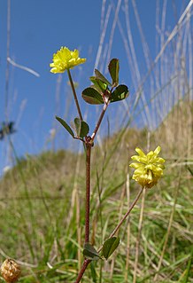
Blow's Down is a 33.1 hectare biological Site of Special Scientific Interest in Dunstable in Bedfordshire. It was notified in 1989 under Section 28 of the Wildlife and Countryside Act 1981, and the local planning authority is Central Bedfordshire Council. The site forms around half of the 62.3 hectare Blow's Downs nature reserve, which is managed by the Wildlife Trust for Bedfordshire, Cambridgeshire and Northamptonshire.

Felmersham Gravel Pits nature reserve in the United Kingdom

Felmersham Gravel Pits is a 21.6 hectare Site of Special Scientific Interest between the villages of Felmersham and Sharnbrook in Bedfordshire. It was notified under Section 28 of the Wildlife and Countryside Act 1981 in 1986 and the local planning authority is Bedford Borough Council. The site is managed by the Wildlife Trust for Bedfordshire, Cambridgeshire and Northamptonshire.

Sharnbrook Summit nature reserve in the United Kingdom

Sharnbrook Summit is a nature reserve between the villages of Sharnbrook and Wymington in Bedfordshire. It has an area of approximately nine hectares, and it is managed by the Wildlife Trust for Bedfordshire, Cambridgeshire and Northamptonshire.

Eye Green Local Nature Reserve

Eye Green Local Nature Reserve is a 12 hectare Local Nature Reserve in Eye Green in Cambridgeshire. It was managed by the Wildlife Trust for Bedfordshire, Cambridgeshire and Northamptonshire until September 2016, when management was transferred to its owner, Peterborough City Council. A small part is also in the Eye Gravel Pit geological Site of Special Scientific Interest.

Gamlingay Cinques nature reserve in the United Kingdom

Gamlingay Cinques is a 3.4 hectare nature reserve in Gamlingay in Cambridgeshire. It is managed by the Wildlife Trust for Bedfordshire, Cambridgeshire and Northamptonshire.

Pingle Cutting nature reserve in the United Kingdom

Pingle Cutting is a 1.0 hectare nature reserve north of Warboys in Cambridgeshire. It is managed by the Wildlife Trust for Bedfordshire, Cambridgeshire and Northamptonshire.

Lings Wood Nature Reserve nature reserve in the United Kingdom

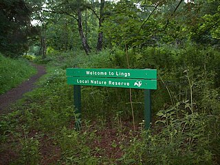
Lings Wood is a 20.1 hectare Local Nature Reserve in eastern Northampton. It is owned by Northampton Borough Council and managed by the Wildlife Trust for Bedfordshire, Cambridgeshire and Northamptonshire.

Summer Leys Local nature reserve in Northamptonshire, England

Summer Leys is a local nature reserve at Wollaston in the Upper Nene Valley, in Northamptonshire, England. It is owned by the Wildlife Trust for Bedfordshire, Cambridgeshire and Northamptonshire.

Irthlingborough Lakes and Meadows nature reserve in the United Kingdom

Irthlingborough Lakes and Meadows is a 117-hectare (290-acre) nature reserve in Northamptonshire, owned and managed by the Wildlife Trust for Bedfordshire, Cambridgeshire and Northamptonshire. The character of the reserve is defined by flooded gravel pits and wet grassland, providing an excellent habitat for large variety of wetland flora and fauna.

Old Warden Tunnel nature reserve nature reserve in the United Kingdom

Old Warden Tunnel nature reserve is a 3.8 hectare nature reserve near Old Warden in Bedfordshire. It is managed by the Wildlife Trust for Bedfordshire, Cambridgeshire and Northamptonshire. The site is on top of a disused railway tunnel, Old Warden Tunnel.

Godmanchester Nature Reserve nature reserve in the United Kingdom

Godmanchester Nature Reserve is a 59 hectare nature reserve in Godmanchester in Cambridgeshire. It is managed by the Wildlife Trust for Bedfordshire, Cambridgeshire and Northamptonshire.

Lattersey Field nature reserve in the United Kingdom

Lattersey Field is an 11.9 hectare Local Nature Reserve in Whittlesey in Cambridgeshire. It is owned by Fenland District Council and managed by the Wildlife Trust for Bedfordshire, Cambridgeshire and Northamptonshire.

Cambourne Nature Reserve nature reserve in the United Kingdom

Cambourne Nature Reserve is a 90 hectare nature reserve in Cambourne in Cambridgeshire. It is managed by the Wildlife Trust for Bedfordshire, Cambridgeshire and Northamptonshire.

Upper Nene Valley Gravel Pits

Upper Nene Valley Gravel Pits is a 1,382.4 hectare biological Site of Special Scientific Interest in a chain of flooded gravel pits along 35 kilometres of the valley of the River Nene between Northampton and Thorpe Waterville in Northamptonshire. It is a Ramsar wetland site of international importance, a Special Protection Area under the European Communities Birds Directive and part of the Nene Valley Nature Improvement Area. It is also part of the River Nene Regional Park. Two areas are managed by the Wildlife Trust for Bedfordshire, Cambridgeshire and Northamptonshire, Summer Leys and Titchmarsh Nature Reserve.

Farthinghoe Nature Reserve nature reserve in the United Kingdom

Farthinghoe Nature Reserve is a 3.7 hectare Local Nature Reserve north-west of Brackley in Northamptonshire. It is owned by Northamptonshire County Council and managed by the Wildlife Trust for Bedfordshire, Cambridgeshire and Northamptonshire.

Limekiln Close and East Pit

Limekiln Close and East Pit is a 10 hectare Local Nature Reserve (LNR) in Cherry Hinton, on the south-eastern outskirts of Cambridge. It is managed by the Wildlife Trust for Bedfordshire, Cambridgeshire and Northamptonshire as Cherry Hinton Chalk Pits. East Pit is part of the Cherry Hinton Pit biological Site of Special Scientific Interest, which excludes Limekiln Close but includes the neighbouring West Pit.

The Plens nature reserve in the United Kingdom

The Plens is a 5 hectare nature reserve in Desborough in Northamptonshire. It is managed by the Wildlife Trust for Bedfordshire, Cambridgeshire and Northamptonshire.

Bradlaugh Fields nature reserve in the United Kingdom

Bradlaugh Fields is a 60 hectare open space in Northampton. The site is a former golf course. In 1987 it was proposed to build housing on the site, but after a campaign by local residents it was acquired by Northampton Borough Council and opened as a wildlife park in 1998. It was named after Charles Bradlaugh, a leading nineteenth century radical and atheist who was MP for Northampton. Three fields with a total area of 17.5 hectares are managed by the Wildlife Trust for Bedfordshire, Cambridgeshire and Northamptonshire as a nature reserve also called Bradlaugh Fields. Hills and Holes is at the southern end and two adjoining meadows, Scrub Field and Quarry Field, are at the northern end. Hills and Holes is an 8.3 hectare Local Nature Reserve (LNR) and Scrub Field is a 5.1 hectare LNR.

References