
The Wildlife Trust for Bedfordshire, Cambridgeshire and Northamptonshire (WTBCN) is a registered charity which manages 126 nature reserves covering 3,945 hectares. It has over 35,000 members, and 95% of people in Bedfordshire, Cambridgeshire and Northamptonshire live within five miles of a reserve. As of 31 March 2016 it employed 105 people and had an income of £5.1 million. It aims to conserve wildlife, inspire people to take action for wildlife, offer advice and share knowledge. The WTBCN is one of 36 wildlife trusts covering England, and 46 covering the whole of the United Kingdom.
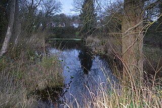
Cople Pits is a 2-hectare (4.9-acre) nature reserve in Cople in Bedfordshire. It is managed by the Wildlife Trust for Bedfordshire, Cambridgeshire and Northamptonshire.

Felmersham Gravel Pits is a 21.6-hectare (53-acre) Site of Special Scientific Interest between the villages of Felmersham and Sharnbrook in Bedfordshire. It was notified under Section 28 of the Wildlife and Countryside Act 1981 in 1986 and the local planning authority is Bedford Borough Council. The site is managed by the Wildlife Trust for Bedfordshire, Cambridgeshire and Northamptonshire.

Dogsthorpe Star Pit is a 36.4-hectare (90-acre) biological Site of Special Scientific Interest (SSSI)) on the eastern outskirts of Peterborough in Cambridgeshire. It is also designated a Local Nature Reserve, and it is managed by the Wildlife Trust for Bedfordshire, Cambridgeshire and Northamptonshire.
Eye Green Local Nature Reserve is a 12 hectare Local Nature Reserve in Eye Green in Cambridgeshire. It was managed by the Wildlife Trust for Bedfordshire, Cambridgeshire and Northamptonshire until September 2016, when management was transferred to its owner, Peterborough City Council. A small part is also in the Eye Gravel Pit geological Site of Special Scientific Interest.

Ramsey Heights Nature Reserve is a small nature reserve near the village of Ramsey Heights in Cambridgeshire, England.

Godmanchester Nature Reserve is a 59-hectare nature reserve in Godmanchester in Cambridgeshire, England. It is managed by the Wildlife Trust for Bedfordshire, Cambridgeshire and Northamptonshire.

Lattersey Field is an 11.9 hectare Local Nature Reserve in Whittlesey in Cambridgeshire. It is owned by Fenland District Council and managed by the Wildlife Trust for Bedfordshire, Cambridgeshire and Northamptonshire.

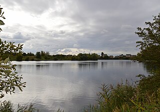
Upper Nene Valley Gravel Pits is a 1,382.4 hectare biological Site of Special Scientific Interest in a chain of flooded gravel pits along 35 kilometres of the valley of the River Nene between Northampton and Thorpe Waterville in Northamptonshire. It is a Ramsar wetland site of international importance, a Special Protection Area under the European Communities Birds Directive and part of the Nene Valley Nature Improvement Area. It is also part of the River Nene Regional Park. Two areas are managed by the Wildlife Trust for Bedfordshire, Cambridgeshire and Northamptonshire, Summer Leys and Titchmarsh Nature Reserve.

Titchmarsh Nature Reserve is a 72.7 hectare Local Nature Reserve north of Thrapston in North Northamptonshire. It is owned and managed by the Wildlife Trust for Bedfordshire, Cambridgeshire and Northamptonshire. It is part of the Upper Nene Valley Gravel Pits Site of Special Scientific Interest.

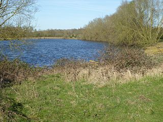
Ditchford Lakes and Meadows is a 31.1-hectare (77-acre) nature reserve Northamptonshire. It is managed by the Wildlife Trust for Bedfordshire, Cambridgeshire and Northamptonshire. It is part of the Upper Nene Valley Gravel Pits Site of Special Scientific Interest, Ramsar wetland site of international importance, and Special Protection Area under the European Communities Birds Directive.

Stoke and Bowd Lane Woods is a 36.4-hectare (90-acre) biological Site of Special Scientific Interest west of Corby in Northamptonshire. The eastern half of Stoke Wood is managed by the Woodland Trust, a triangular area of 0.7 hectares which stretches south from the middle is the Stoke Wood End Quarter, a nature reserve managed by the Wildlife Trust for Bedfordshire, Cambridgeshire and Northamptonshire, and the remaining western part of the wood is private property. Bowd Lane Wood is private property.

Stoke Wood End Quarter is a 0.7-hectare (1.7-acre) nature reserve west of Corby in Northamptonshire. It is managed by the Wildlife Trust for Bedfordshire, Cambridgeshire and Northamptonshire, and is part of the Stoke and Bowd Lane Woods Site of Special Scientific Interest.

Byfield Pool is a 4 hectare nature reserve west of Byfield in Northamptonshire. It was managed by the Wildlife Trust for Bedfordshire, Cambridgeshire and Northamptonshire until 2020, when management was handed back to the Canal & River Trust, who own the site.

Storton's Pits is a 21.9 hectare Local Nature Reserve in Northampton. It is managed by the Wildlife Trust for Bedfordshire, Cambridgeshire and Northamptonshire.

Duston Mill Meadow is a one hectare nature reserve in Northampton. It is managed by the Wildlife Trust for Bedfordshire, Cambridgeshire and Northamptonshire (WTBCN).
Higham Ferrers Pits is a 10 hectare nature reserve Northamptonshire. It is managed by the Wildlife Trust for Bedfordshire, Cambridgeshire and Northamptonshire. It is part of the Upper Nene Valley Gravel Pits Site of Special Scientific Interest, Ramsar internationally important wetland site and Special Protection Area under the EC Birds Directive.
Wilson's Pits is a 32 hectare nature reserve west of Higham Ferrers in Northamptonshire. It is managed by the Wildlife Trust for Bedfordshire, Cambridgeshire and Northamptonshire. It is part of the Upper Nene Valley Gravel Pits Site of Special Scientific Interest, Ramsar internationally important wetland site and Special Protection Area under the EC Birds Directive.

Grafton Regis Meadow is a 2-hectare (4.9-acre) nature reserve east of Grafton Regis in Northamptonshire. It is managed by the Wildlife Trust for Bedfordshire, Cambridgeshire and Northamptonshire.

