The Riddy

Last updated

The Riddy and the River Ivel The Riddy and River ivel.JPG
The Riddy and the River Ivel

The Riddy is an 8.4 hectare flood meadow and Local Nature Reserve located in Sandy, Bedfordshire, United Kingdom, bordering the River Ivel. Owned by Sandy Town Council but managed by both the Wildlife Trust for Bedfordshire, Cambridgeshire and Northamptonshire and Bedfordshire Rural Communities Charity, [1] the 7.7 hectares (19 acres) site gains its name from a small stream which flows through the eastern end of the reserve. [2] [3] [4] The different habitats in the Riddy support a diverse range of species, including a multiplicity of grasses and flowering plants in the meadows, aquatic plants and water voles which inhabit the ditches, ponds and stream, and birds which feed and hunt across the reserve. [2]

Contents

The Riddy is currently open to the general public; although some of the paths are reasonably rough, the site is most accessible via the riverside path: a disabled access gate is provided as well. [1] [2] [3] The River Ivel may be fished from the reserve border, but a permit from the town council and national rod licence are required. [1]

History

The River Ivel used to be bordered by a number of flood meadows, many of which have now been lost: [5] The Riddy is a remnant of this previous network. [2] [3] In the thirteenth century CE, the area now known as The Riddy was referred to as "Parkesriding". [6] In the north-eastern corner of the reserve, a mill pool can be found; whilst the last mill was built here in 1857, evidence shows that mills have been built on the Riddy since at least Norman times. [1]

Local Nature Reserve

Declared a Local Nature Reserve in 2006 by Sandy Town Council and designated an 'Urban Fringe' site, The Riddy is a species rich habitat, [1] [3] being described by the Wildlife Trust for Bedfordshire, Cambridgeshire and Northamptonshire as "an oasis of wild flowers, bird song and a wonderful view among a sea of arable fields". [7] In the meadows many different grasses and other plants grow, such as cuckoo flower ( Cardamine pratensis ). The pond, stream and ditches support aquatic plants, such as arrowhead ( Sagittaria sagittifolia ), celery-leaved buttercup ( Ranunculus sceleratus ), purple-loosestrife ( Lythrum salicaria ), water-plantain ( Alisma plantago-aquatica ) [2] and duckweed. [8] Chub ( Squalius cephalus ) and carp can both be found in the 500 yards (460 m) stream, [9] along with the nationally protected water vole ( Arvicola amphibius ). [2] Numerous birds frequent The Riddy, some which feed in the meadows including redwing ( Turdus iliacus ), fieldfare ( Turdus pilaris ) and northern lapwing ( Vanellus vanellus ), whilst sparrowhawks ( Accipiter nisus ) have been observed "patrolling" the mature hedgerows. Grey herons ( Ardea cinerea ) and common terns ( Sterna hirundo ) hunt fish, and in the autumn, song thrushes ( Turdus philomelos ) can be seen at the reserve. [2] [7] Grey wagtail ( Motacilla cinerea ) and kingfisher ( Alcedo atthis ) have also been recorded on the reserve. [2]

The reserve is managed by both the Wildlife Trust for Bedfordshire, Cambridgeshire and Northamptonshire and Bedfordshire Rural Communities Charity through its volunteer group 'Ivel Valley Conservation Volunteers'. Management tasks performed on The Riddy include the coppicing of the willows in the small osier bed which stimulates new growth, grazing with cattle to remove each season's growth and to maintain the grassland habitats, [7] along with the removal ('pulling') of ragwort ( Jacobaea vulgaris ) which is poisonous to certain animals, notably the grazing cattle, when ingested. [10]

Related Research Articles

<span class="mw-page-title-main">Wildlife Trust for Bedfordshire, Cambridgeshire and Northamptonshire</span> Charity in Bedfordshire, Cambridgeshire and Northamptonshire

The Wildlife Trust for Bedfordshire, Cambridgeshire and Northamptonshire (WTBCN) is a registered charity which manages 126 nature reserves covering 3,945 hectares. It has over 35,000 members, and 95% of people in Bedfordshire, Cambridgeshire and Northamptonshire live within five miles of a reserve. In the year to 31 March 2016 it employed 105 people and had an income of £5.1 million. It aims to conserve wildlife, inspire people to take action for wildlife, offer advice and share knowledge. The WTBCN is one of 36 wildlife trusts covering England, and 46 covering the whole of the United Kingdom.

<span class="mw-page-title-main">Great Fen</span> Habitat restoration project in England

The Great Fen is a habitat restoration project being undertaken on The Fens in the county of Cambridgeshire in England. It is one of the largest restoration projects in the country, and aims to create a 3,700 hectare wetland and aims to connect Woodwalton Fen National Nature Reserve (NNR), Holme Fen NNR and other nature reserves to create a larger site with conservation benefits for wildlife and socio-economic benefits for people.

<span class="mw-page-title-main">Arlesey Old Moat and Glebe Meadows</span>

Arlesey Old Moat and Glebe Meadows is a 4.3 hectare nature reserve west of Arlesey in Bedfordshire. It is managed by the Wildlife Trust for Bedfordshire, Cambridgeshire and Northamptonshire. The site is a long narrow strip between the River Hiz and the East Coast Main Line, with the entrance to Glebe Meadows immediately west of Arlesey railway station, and Arlesey Old Moat south of the Meadows. The Hicca Way footpath goes through the site.

<span class="mw-page-title-main">Lancot Meadow</span>

Lancot Meadow is a 2-hectare (4.9-acre) nature reserve in western Dunstable in Bedfordshire. It is managed by the Wildlife Trust for Bedfordshire, Cambridgeshire and Northamptonshire.

<span class="mw-page-title-main">Sharnbrook Summit</span>

Sharnbrook Summit is a nature reserve between the villages of Sharnbrook and Wymington in Bedfordshire. It has an area of approximately nine hectares, and it is managed by the Wildlife Trust for Bedfordshire, Cambridgeshire and Northamptonshire.

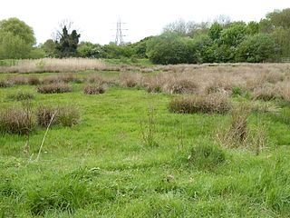
Warren Villas was a nature reserve managed by the Wildlife Trust for Bedfordshire, Cambridgeshire and Northamptonshire. The former site is situated by the River Ivel to the south of the town of Sandy in the county of Bedfordshire.

<span class="mw-page-title-main">Upwood Meadows</span>

Upwood Meadows is a 6 hectare biological Site of Special Scientific Interest west of Upwood in Cambridgeshire. It is also a National Nature Reserve and a Grade I Nature Conservation Review site. It is managed by the Wildlife Trust for Bedfordshire, Cambridgeshire and Northamptonshire.

<span class="mw-page-title-main">Wymington Meadow</span>

Wymington Meadow is a nature reserve south of Wymington in Bedfordshire. It is approximately one hectare, and is managed by the Wildlife Trust for Bedfordshire, Cambridgeshire and Northamptonshire.

<span class="mw-page-title-main">Irthlingborough Lakes and Meadows</span>

Irthlingborough Lakes and Meadows is a 117-hectare (290-acre) nature reserve in Northamptonshire, owned and managed by the Wildlife Trust for Bedfordshire, Cambridgeshire and Northamptonshire. The character of the reserve is defined by flooded gravel pits and wet grassland, providing an excellent habitat for large variety of wetland flora and fauna.

<span class="mw-page-title-main">Lattersey Field</span>

Lattersey Field is an 11.9 hectare Local Nature Reserve in Whittlesey in Cambridgeshire. It is owned by Fenland District Council and managed by the Wildlife Trust for Bedfordshire, Cambridgeshire and Northamptonshire.

<span class="mw-page-title-main">Cambourne Nature Reserve</span>

Cambourne Nature Reserve is a 90 hectare nature reserve in Cambourne in Cambridgeshire. It is managed by the Wildlife Trust for Bedfordshire, Cambridgeshire and Northamptonshire.

<span class="mw-page-title-main">Kingsthorpe Meadow</span>

Kingsthorpe Meadow is a 14.4 hectare Local Nature Reserve in Northampton. It is owned by Northampton Borough Council and managed by the Wildlife Trust for Bedfordshire, Cambridgeshire and Northamptonshire.

<span class="mw-page-title-main">Great Oakley Meadow</span>

Great Oakley Meadow is a 1.9 hectare Local Nature Reserve in Great Oakley, on the southern outskirts of Corby in Northamptonshire. It is managed by the Wildlife Trust for Bedfordshire, Cambridgeshire and Northamptonshire.

<span class="mw-page-title-main">Barford Wood and Meadows</span>

Barford Wood and Meadows or Barford Meadow Nature Reserve is a 36 hectare nature reserve east of Rushton in Northamptonshire. It is managed by the Wildlife Trust for Bedfordshire, Cambridgeshire and Northamptonshire. The north-eastern end is part of the River Ise and Meadows Site of Special Scientific Interest.

<span class="mw-page-title-main">Storton's Pits</span>

Storton's Pits is a 21.9 hectare Local Nature Reserve in Northampton. It is managed by the Wildlife Trust for Bedfordshire, Cambridgeshire and Northamptonshire.

<span class="mw-page-title-main">Duston Mill Meadow</span>

Duston Mill Meadow is a one hectare nature reserve in Northampton. It is managed by the Wildlife Trust for Bedfordshire, Cambridgeshire and Northamptonshire (WTBCN).

<span class="mw-page-title-main">Grafton Regis Meadow</span>

Grafton Regis Meadow is a 2-hectare (4.9-acre) nature reserve east of Grafton Regis in Northamptonshire. It is managed by the Wildlife Trust for Bedfordshire, Cambridgeshire and Northamptonshire.

<span class="mw-page-title-main">Abington Meadows</span>

Abington Meadows is a 9.6-hectare (24-acre) nature reserve in Northampton. It is owned by Northamptonshire County Council and managed by the Wildlife Trust for Bedfordshire, Cambridgeshire and Northamptonshire.

References

  1. 1 2 3 4 5 "The Riddy". Sandy Town Council. Archived from the original on 2 February 2014. Retrieved 18 January 2014.
  2. 1 2 3 4 5 6 7 8 "The Riddy". Wildlife Trust for Bedfordshire, Cambridgeshire and Northamptonshire. Archived from the original on 18 July 2014. Retrieved 18 January 2014.
  3. 1 2 3 4 "The Riddy". Local Nature Reserves. Natural England. 19 February 2013. Retrieved 23 March 2016.
  4. "Map of The Riddy". Local Nature Reserves. Natural England. Retrieved 23 March 2016.
  5. "TYPE 4: CLAY VALLEYS" (PDF). Mid Bedfordshire Landscape Character Assessment Land Use Consultants. Central Bedfordshire. p. 6. Archived from the original (PDF) on 30 August 2012. Retrieved 18 January 2014.
  6. Rutt, Michael. "WHAT'S IN A NAME? - PLACE NAMES IN SANDY". Sandy Historical Research Group. Archived from the original on 3 February 2014. Retrieved 18 January 2014.
  7. 1 2 3 "Bedfordshire Nature Reserves". Where to see wildlife in Bedfordshire, Cambridgeshire & Northamptonshire. Wildlife Trust for Bedfordshire, Cambridgeshire and Northamptonshire. p. 43. ISBN   9781874357391.
  8. Niemann, Derek (20 April 2012). "Country diary: Sandy, Bedfordshire: At the mouth of the Riddy there is only cracked earth". The Guardian . Retrieved 18 January 2014.
  9. "The Riddy". Biggleswade & Hitchin Angling Association Ltd. Archived from the original on 4 March 2016. Retrieved 18 January 2014.
  10. Summer Diary, Ivel Valley Conservation Volunteers, July–September 2013

52°07′29″N0°17′46″W / 52.1247°N 0.2960°W / 52.1247; -0.2960