
Arunachal Pradesh is a state in northeast India. It was formed from the North-East Frontier Agency (NEFA) region, and India declared it as a state on 20 February 1987. Itanagar is its capital and largest town. It borders the Indian states of Assam and Nagaland to the south. It shares international borders with Bhutan in the west, Myanmar in the east, and a disputed 1,129 km border with China's Tibet Autonomous Region in the north at the McMahon Line. Arunachal Pradesh is claimed by China as part of the Tibet Autonomous Region; China occupied some regions of Arunachal Pradesh in 1962 but later withdrew its forces.

The Satpura Range is a range of hills in central India. The range rises in eastern Gujarat running east through the border of Maharashtra and Madhya Pradesh and ends in Chhattisgarh. The range parallels the Vindhya Range to the north, and these two east–west ranges divide Indian Subcontinent into the Indo-Gangetic plain of northern India and the Deccan Plateau of the south. The Narmada River originates from north-eastern end of Satpura in Amarkantak, and runs in the depression between the Satpura and Vindhya ranges, draining the northern slope of the Satpura range, running west towards the Arabian Sea. The Tapti River originates in the eastern-central part of Satpura, crossing the range in the center and running west at the range's southern slopes before meeting the Arabian Sea at Surat, draining the central and southern slopes of the range. Multai, the place of Tapi river origin is located about 465 kilometer far, south-westerly to Amarkantak, separated across by the hill range. The Godavari River and its tributaries drain the Deccan plateau, which lies south of the range, and the Mahanadi River drains the easternmost portion of the range. The Godavari and Mahanadi rivers flow into the Bay of Bengal. At its eastern end, the Satpura range meets the hills of the Chotanagpur Plateau. The Satpura Range is a horst mountain and is flanked by Narmada Graben in the north and much smaller but parallel Tapi Graben in the south.

West Siang district is an administrative district in the state of Arunachal Pradesh in India.
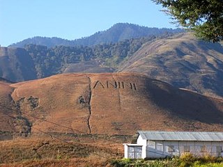
Anini is the headquarters of the Dibang Valley district in the state of Arunachal Pradesh in Northeast India. Anini was also the district headquarters of the undivided Dibang Valley district. Most of this location's population consists of the Idu Mishmi tribal people. Due to its remote location, Anini remains a small and underdeveloped town. However, it still has basic road and air links to the rest of India. The town is fully dependent on the nearest major settlement, Roing, which is in the Lower Dibang Valley District, for most commercial needs.

Nameri National Park is a national park in the foothills of the eastern Himalayas in the Sonitpur District of Assam, India, about 35 km from Tezpur. Nameri is about 9 km from Chariduar, the nearest village.

The Brahmaputra Valley semi-evergreen forests is a tropical moist broadleaf forest ecoregion of Northeastern India, southern Bhutan and adjacent Bangladesh.

Namdapha National Park is a 1,985 km2 (766 sq mi) large protected area in Arunachal Pradesh of Northeast India. The park was established in 1983. With more than 1,000 floral and about 1,400 faunal species, it is a biodiversity hotspot in the Eastern Himalayas. The national park harbours the northernmost lowland evergreen rainforests in the world at 27°N latitude. It also harbours extensive dipterocarp forests, comprising the northwestern parts of the Mizoram-Manipur-Kachin rain forests ecoregion.

The Eastern Himalayan broadleaf forests is a temperate broadleaf forest ecoregion found in the middle elevations of the eastern Himalayas, including parts of Nepal, India, Bhutan, Myanmar and China. These forests have an outstanding richness of wildlife.

Eaglenest or Eagle's Nest Wildlife Sanctuary is a protected area of India in the Himalayan foothills of West Kameng District, Arunachal Pradesh. It conjoins Sessa Orchid Sanctuary to the northeast and Pakhui Tiger Reserve across the Kameng river to the east. Altitude ranges are extreme: from 500 metres (1,640 ft) to 3,250 metres (10,663 ft). It is a part of the Kameng Elephant Reserve.

Sessa Orchid Sanctuary is a 100 km2 protected area of India in the Himalayan foothills in Bhalukpong Forest Division of West Kameng District, Arunachal Pradesh. It conjoins Eaglenest Wildlife Sanctuary to the southwest. It is a part of the Kameng Protected Area Complex (KPAC), which is an Elephant Reserve. See map. The department of Environment & Forests has developed trekking routes for visitors to enjoy the natural habitats of orchids. There are deep gorges and valleys, high peaks and rugged terrain that are rewarding for nature lovers and adventure tourists. A nursery includes representative specimens of various orchid species of the sanctuary and a demonstration farm of Cymbidium hybrids for cut-flower production. Most of Sessa has traditionally been claimed by the Bugun tribe as part of their territory.
The Kameng Elephant Reserve is an Elephant Reserve located in the Himalayan foothills of Arunachal Pradesh, India, in the districts of West Kameng and East Kameng.

The Kingdom of Bhutan is a small, landlocked nation nestled in the southern slopes of the Eastern Himalaya. To its north lies the Tibet Autonomous Region of China and to the west, south and east lies the Indian states of Sikkim, Bengal, Assam and Arunachal Pradesh.
Pakke Tiger Reserve, is a Project Tiger reserve in the East Kameng district of Arunachal Pradesh in Northeast India. The 862 km2 (333 sq mi) reserve is protected by the Department of Environment and Forest of Arunachal Pradesh. It was known as Pakhui Tiger Reserve, but renamed in April 2001 by the Governor of Arunachal Pradesh. It has won India Biodiversity Award 2016 in the category of 'Conservation of threatened species' for its Hornbill Nest Adoption Programme.

Dehing Patkai National Park is a national park in the Dibrugarh and Tinsukia districts of Assam covering an area of 231.65 km2 (89.44 sq mi) of rainforest. It was declared a wildlife sanctuary on 13 June 2004. On 13 December 2020, the Government of Assam upgraded it into a national park. On 9 June 2021, the Forest Department of Assam officially notified it as a national park. It is located in the Dehing Patkai Landscape which is a dipterocarp-dominated lowland rainforest. The rainforest stretches for more than 575 km2 (222 sq mi) in the districts of Dibrugarh, Tinsukia and Charaideo. The forest further spreads over in the Tirap and Changlang districts of Arunachal Pradesh. Dehing Patkai National Park harbours the largest stretch of lowland rainforests in India. Dehing Patkai Wildlife Sanctuary was declared as Dehing Patkai Elephant Reserve under Project Elephant. Dehing-Patkai as a potential wildlife sanctuary was identified in late 1980s during a primate survey as "Upper Dehing Wildlife Sanctuary". Subsequently during a study on white-winged wood duck in early 1990s, it was discovered as a globally important site for this duck and recommended to be upgraded to "Upper Dehing National Park".

The Department of Environment and Forests of Arunachal Pradesh (DEFAP) is a state-sponsored agency responsible for conserving the environment, identifying, establishing, and conserving protected areas in the Indian state of Arunachal Pradesh.

The Mishmi Hills are located at the northeastern tip of India, in northeastern Arunachal Pradesh. On the Chinese side, they form the southern parts of Nyingchi Prefecture in the Tibet Autonomous Region.

Arunachal Pradesh is primarily a hilly tract nestled in the foothills of the Himalayas in northeast India. It is spread over an area of 83,743 km2 (32,333 sq mi). 98% of the geographical area is land out of which 80% is forest cover; 2% is water. River systems in the region, including those from the higher Himalayas and Patkoi and Arakan Ranges, eventually drain into the Brahmaputra River.

The Kamlang Wildlife Sanctuary, established in 1989, is the 50th Tiger reserve in India. The Sanctuary is rich with floral and faunal diversity. It is situated in the Lohit District of the northeastern Indian state of Arunachal Pradesh. The park is named after the Kamlang River which flows through it. The Mishmi, Digaro Mishmi, and Miju Mishmi people tribal people who reside around the periphery of the sanctuary claim their descent from the King Rukmo of the epic Mahabharata. They believe in a myth of an invisible god known as Suto Phenkhenynon jamalu. An important body of water in the sanctuary is the Glow Lake. Located in tropical and sub-tropical climatic zones, the sanctuary is the habitat of the four big cat species of India: tiger, leopard, clouded leopard and snow leopard.
D'Ering Memorial Wildlife Sanctuary is a protected area in Arunachal Pradesh, India, with an area of 190 km2 (73 sq mi). It was established in 1978.

The Mehao wildlife sanctuary was declared with an aim to conserve the biodiversity around the Mehao Lake. The sanctuary is gifted with virgin natural lush green forest and lakes. The sanctuary harbours some rare varieties of orchids. The altitude of the sanctuary varies from 900 to 3500 meters. The sanctuary covers 281.5 km2 (108.7 sq mi). Its average winter temperature is 12 °C (54 °F) and its average summer temperature is 36 °C (97 °F).

