
Rockland County is the southernmost county on the west side of the Hudson River in the U.S. state of New York, part of the New York City metropolitan statistical area. It is a suburb of New York City that is about 6 miles from the Bronx at their closest points. The county's population, as of the 2020 United States Census, is 338,329, making it the third-most densely populated county outside New York City within New York. The county seat is New City. Rockland County is accessible via the New York State Thruway, which crosses the Hudson to Westchester at the Tappan Zee Bridge ten exits up from the Bronx, as well as the Palisades Parkway five exits up from the George Washington Bridge. The county's name derives from "rocky land", as the area has been aptly described, largely due to the Hudson River Palisades.
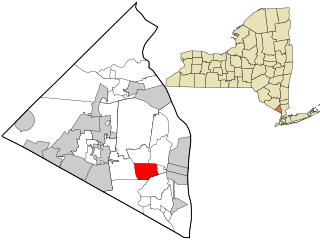
West Nyack is a hamlet and census-designated place in the town of Clarkstown, Rockland County, New York, United States. It is located north of Blauvelt, east of Nanuet, southwest of Valley Cottage, southeast of Bardonia, and west of Central Nyack. It is approximately 18 miles (29 km) north of New York City. The population was 3,439 at the 2010 census.

Haverstraw is a town in Rockland County, New York, United States, located north of the Town of Clarkstown and the Town of Ramapo; east of Orange County, New York; south of the Town of Stony Point; and west of the Hudson River. The town runs from the west to the east border of the county in its northern part. The population was 36,634 at the 2010 census. The name comes from the Dutch word Haverstroo meaning "oats straw", referring to the grasslands along the river. The town contains three villages, one of which is also known as Haverstraw. Haverstraw village is the original seat of government for the town, hosting the area's historic central downtown business district and the densest population in northern Rockland County.
Stony Point is a town in Rockland County, New York, United States. It is part of the New York City Metropolitan Area. The town is located north of the town of Haverstraw, east and south of Orange County, New York, and west of the Hudson River and Westchester County. The population was 15,059 at the 2010 census. The name of the town is derived from a prominent projection into the Hudson River.
The Palisades Interstate Parkway (PIP) is a 38.25-mile-long (61.56 km) limited-access highway in the U.S. states of New Jersey and New York. The parkway is a major commuter route into New York City from Rockland and Orange counties in New York and Bergen County in New Jersey. The southern terminus of the route is at the George Washington Bridge in Fort Lee, New Jersey, where it connects to Interstate 95 (I-95), New Jersey Route 4, U..S. 1, U.S. 9, and US 46. Its northern terminus is at a traffic circle in Fort Montgomery, New York, where the PIP meets US 9W and US 202 at the Bear Mountain Bridge. At exit 18, the PIP forms a concurrency with US 6 for the remaining duration of its run.

At 47,527 acres (192.33 km2), Harriman State Park is the second largest state park in New York State. Located in Rockland and Orange counties 30 miles (48 km) north of New York City, it is a haven for hikers with over 200 miles (320 km) of hiking trails. The park is also known for its 31 lakes, multiple streams, public camping area, and great vistas. The park's hiking trails are currently maintained by volunteers from the New York - New Jersey Trail Conference.

Rockland Lake State Park is a 1,133-acre (4.59 km2) state park located in the hamlets of Congers and Valley Cottage in the eastern part of the Town of Clarkstown in Rockland County, New York, United States. The park is located on a ridge of Hook Mountain above the west bank of the Hudson River. Included within the park is the 256-acre (1.04 km2) Rockland Lake.

Palisades Interstate Park and its governing body, the Palisades Interstate Park Commission, was formed under an interstate compact in 1900 by governors Theodore Roosevelt of New York and Foster M. Voorhees of New Jersey in response to the destruction of the Palisades by quarry operators in the late 19th century. The Palisades are the cliffs on the west bank of the Hudson River across from and continuing north of Manhattan Island. The commission consists of ten commissioners, five appointed by each governor, who serve staggered five-year terms.

Doodletown was an isolated hamlet in the Town of Stony Point, Rockland County, New York, United States. Purchased by the Palisades Interstate Park Commission during the 1960s, it is now part of Bear Mountain State Park and a popular destination for hikers, birdwatchers, botanists, and local historians. It is located north of Jones Point, west of Iona Island, and southeast of Orange County. The former settlement is now a ghost town.

Stony Point Battlefield is a historic site in Rockland County, New York; the location of the 1779 Battle of Stony Point during the American Revolutionary War. It is a National Historic Landmark and has a museum.
Tomkins Cove is a hamlet in the Town of Stony Point, Rockland County, New York, United States, located north of Stony Point; east of Harriman State Park; south of Doodletown and west of the Hudson River. It is located north-northwest of New York City. The population is approximately 1,739 and the ZIP Code is 10986. The community is served by the 786 exchange in area code 845.
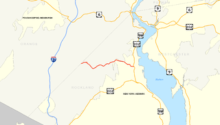
County Route 106 (CR 106) is a 7.8-mile (12.6 km) east–west county route in Rockland County, New York, in the United States. It serves as an eastward continuation of Kanawauke Road, extending from the Orange County line to U.S. Route 9W (US 9W) and US 202 in Stony Point via Harriman State Park. CR 106 intersects with several county highways in Rockland County along the way. The route was only one of two in Rockland County to keep its numbering from Orange County, with the other being CR 72. CR 106 had one spur route, CR 106A, which was recently decommissioned.
Seven Lakes Drive is a north–south parkway located in the Hudson Valley region of New York in the United States. It extends for just under 18 miles (29 km) on a northeast–southwest alignment from an intersection with New York State Route 17 (NY 17) in the village of Sloatsburg to a junction with U.S. Route 9W (US 9W) and US 202 south of the Bear Mountain Bridge in the town of Stony Point. Most of the highway is located in either Harriman or Bear Mountain state parks, except for a small stretch near its western end. Ownership of Seven Lakes Drive is split between three entities, two of which are also responsible for maintenance of the road.
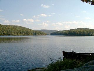
At 310 acres (1.3 km2), Lake Sebago, near Sloatsburg, is the largest lake in Harriman State Park in the U.S. state of New York. The name is Algonquian for "big water". It is located just south of Lake Kanawauke and is accessible via Seven Lakes Drive and the Palisades Interstate Parkway. New Sebago Beach opened in the 1940s but closed in 2011 due to damage from Hurricane Irene, and the picnic areas closed in 2012 due to Hurricane Sandy.

County Route 106 (CR 106) in the county of Orange County, New York was a continuation of two routes, New York State Route 17A (NY 17A) at its western terminus and Rockland CR 106 at the eastern terminus. Route 106 began at an intersection with NY 17A and its parent route, NY 17 in Southfields, where CR 106 signs are still posted according to the August 2018 Google Street View images. The route went eastward through Harriman State Park, crossing Seven Lakes Drive before entering nearby Rockland County, New York. There it became Rockland County Route 106 and heads all the way to Stony Point.
The recorded history of Rockland County, New York begins on February 23, 1798, when the county was split off from Orange County, New York and formed as its own administrative division of the state of New York. It is located 6 miles (9.7 km) north-northwest of New York City, and is part of the New York Metropolitan Area. The county seat is the hamlet of New City. The name comes from rocky land, an early description of the area given by settlers. Rockland is New York's southernmost county west of the Hudson River. It is suburban in nature, with a considerable amount of scenic designated parkland. Rockland County does not border any of the New York City boroughs, but is only 9.5 miles (15.3 km) north of Manhattan at the counties' two respective closest points
Lake Welch Parkway, sometimes labeled Lake Welch Drive, is a scenic road located within Harriman State Park in southern New York in the United States. It extends for 5.60 miles (9.01 km) on a southwest–northeast alignment from an intersection with Seven Lakes Drive to a partial interchange with the Palisades Interstate Parkway. The highway is located entirely in Rockland County, although it runs close to the border with Orange County. It is inventoried by the New York State Department of Transportation as New York State Route 987A, an unsigned reference route; however, it is owned by the Palisades Interstate Park Commission. The portion of Lake Welch Parkway that lies south of Tiorati Brook Road is closed during the winter. The parkway is the main route to access all beaches in Harriman State Park: Lake Welch, Lake Tiorati, and Lake Sebago.
Tiorati Brook Road is a scenic road located within Harriman State Park in southern New York in the United States. The highway extends for 3.6 miles (5.8 km) between Tiorati Circle, a traffic circle connecting Tiorati Brook Road to Seven Lakes Drive in Orange County, and an interchange with Lake Welch Parkway just west of where that parkway ends at Palisades Interstate Parkway in Rockland County. The road crosses over the county line roughly midway between the two locations. Tiorati Brook Road is owned and maintained by the Palisades Interstate Park Commission.
Haverstraw Beach State Park is a 73-acre (0.30 km2) state park located in the Town of Haverstraw in Rockland County, New York. The park is included within the Palisades Interstate Park system and is functionally part of a continuous complex of parks that also includes Rockland Lake State Park, Hook Mountain State Park, and Nyack Beach State Park.


