Related Research Articles

Rockland County is the southernmost county on the west side of the Hudson River in the U.S. state of New York. It is part of the New York metropolitan area. As of the 2020 U.S. census, the county's population is 338,329, making it the state's third-most densely populated county outside New York City after Nassau and neighboring Westchester Counties. The county seat and largest hamlet is New City. Rockland County is accessible via both the New York State Thruway, which crosses the Hudson River to Westchester via the Tappan Zee Bridge over the Tappan Zee, ten exits up from the NYC border; and the Palisades Parkway, four exits up, via the George Washington Bridge. The county's name derives from "rocky land", as the area has been aptly described, largely due to the Hudson River Palisades. The county is part of the Hudson Valley region of the state.

Airmont is a village in the town of Ramapo, Rockland County, New York, United States, located north of the state of New Jersey, east of Suffern, south of Montebello, and west of Chestnut Ridge. The population was 10,166 at the 2020 census.

Hillcrest is a hamlet incorporated in 1893 and census-designated place, in the town of Ramapo, Rockland County, New York, United States. It is located north of Spring Valley, east of Viola, south of New Square and New Hempstead, and west of New City. The population was 8,164 at the 2020 census.
Monsey is a hamlet and census-designated place in the town of Ramapo, Rockland County, New York, United States, north of Airmont, east of Viola, south of New Hempstead, and west of Spring Valley. The village of Kaser is surrounded by the hamlet of Monsey. The 2020 census listed the population at 26,954.

Montebello is an incorporated village in Ramapo, Rockland County, New York, United States. It is located north of Suffern, east of Hillburn, south of Wesley Hills, and west of Airmont. The population was 4,507 at the 2020 census.

Mount Ivy is a hamlet and census-designated place in the Town of Haverstraw, in Rockland County, New York, United States. It is located north of New City, east of Pomona, south of Thiells, and west of Garnerville. The population was 6,878 at the 2010 census.

New Square is an all-Hasidic village in the town of Ramapo, Rockland County, New York, United States. It is located north of Hillcrest, east of Viola, south of New Hempstead, and west of New City. As of the 2020 United States census, it had a population of 9,679. Its inhabitants are predominantly members of the Skverer Hasidic movement who seek to maintain a Hasidic lifestyle disconnected from the secular world. It is the poorest town in New York, and the eighth poorest in the United States. It also has the highest poverty rate, at 64.4%.

Piermont is a village incorporated in 1847 in Rockland County, New York, United States. Piermont is in the town of Orangetown, located north of the hamlet of Palisades, east of Sparkill, and south of Grand View-on-Hudson, on the west bank of the Hudson River. The population was 2,517 at the 2020 census. Woody Allen set The Purple Rose of Cairo (1984) in Piermont.

Ramapo is a town in Rockland County, New York, United States. It was originally formed as New Hampstead, in 1791, and became Ramapo in 1828. It shares its name with the Ramapo River. As of the 2020 census, Ramapo had a total population of 148,919, making it the most populous town in New York outside of Long Island. If all towns in New York were cities, Ramapo would be the 12th-largest city in the state of New York.
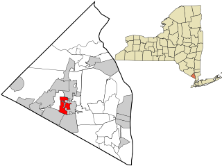
Spring Valley is a village in the town of Ramapo and Clarkstown in Rockland County, New York, United States. It is located north of Chestnut Ridge, east of Airmont and Monsey, south of Hillcrest, and west of Nanuet. The population was 33,066 at the 2020 census, making it the second most populous community in both Clarkstown and Rockland County, after New City.

Viola is a hamlet and census-designated place in the town of Ramapo, Rockland County, New York, United States. It is located north of Airmont, east of Montebello, south of Wesley Hills, and west of Hillcrest. The population was 6,868 at the 2010 census.

Rockland is a town in the northern part of Sullivan County, New York, United States. At the 2020 census, the population was 3,290.

Rockland Community College (RCC) is a public community college in Rockland County, New York. It is part of the State University of New York. The college, established in 1959, became the 18th community college to join the SUNY system. The college offers 51 programs and offers associate degrees and certificates. Additionally, students can earn other degrees, including Bachelor of Arts, Bachelor of Science, Master of Arts in the arts and sciences, Doctoral Program in Executive Leadership (EdD), technology, and health professions while attending classes at Rockland through articulation programs with four-year schools. The current enrollment is 6,859 students.

Ramapo Mountain State Forest is a 4,200-acre (17 km2) state forest in Bergen and Passaic Counties in New Jersey. The park is operated and maintained by the New Jersey Division of Parks and Forestry.

Stony Point Battlefield is a historic site in Rockland County, New York; the location of the 1779 Battle of Stony Point during the American Revolutionary War. It is a National Historic Landmark and has a museum.

Suffern Central School District, formerly the Ramapo Central School District, is a school district headquartered in Hillburn, a village in the Town of Ramapo in Rockland County, New York, United States. It is located north of Suffern; east of Orange County, New York; south of Viola and west of Montebello.
The Mahwah River is a tributary of the Ramapo River in Rockland County, New York and Bergen County, New Jersey in the United States.

Sloat's Dam and Mill Pond is located between Waldron Terrace and Ballard Avenue in Sloatsburg, New York, United States. The 200-foot–long concrete dam creates the mill pond north of it by impounding the Ramapo River.
Ladentown is a hamlet in the Town of Haverstraw, Rockland County, New York, United States, is located in the center of a triangle between Haverstraw, Pomona and Suffern and two miles west of Mount Ivy. It is located north-northwest of New York City.
The recorded history of Rockland County, New York begins on February 23, 1798, when the county was split off from Orange County, New York and formed as its own administrative division of the state of New York. It is located 6 miles (9.7 km) north-northwest of New York City, and is part of the New York Metropolitan Area. The county seat is the hamlet of New City. The name comes from rocky land, an early description of the area given by settlers. Rockland is New York's southernmost county west of the Hudson River. It is suburban in nature, with a considerable amount of scenic designated parkland. Rockland County does not border any of the New York City boroughs, but is only 9.5 miles (15.3 km) north of Manhattan at the counties' two respective closest points
