Thiells, New York

Last updated
Thiells, New York
Rockland County New York incorporated and unincorporated areas Thiells highlighted.svg
Location in Rockland County and the state of New York.
USA New York location map.svg
Red pog.svg
Thiells, New York
Location within the state of New York
Coordinates: 41°12′27″N74°0′25″W / 41.20750°N 74.00694°W / 41.20750; -74.00694 Coordinates: 41°12′27″N74°0′25″W / 41.20750°N 74.00694°W / 41.20750; -74.00694
Country United States
State New York
County Rockland
Area
[1]
  Total1.85 sq mi (4.79 km2)
  Land1.82 sq mi (4.70 km2)
  Water0.03 sq mi (0.08 km2)
Elevation
276 ft (84 m)
Population
 (2020)
  Total5,240
  Density2,885.46/sq mi (1,114.37/km2)
Time zone UTC−5 (Eastern (EST))
  Summer (DST) UTC−4 (EDT)
ZIP Code
10984
Area code 845
FIPS code 36-73583
GNIS feature ID0967361

Thiells, known as Thiell's Corner in the 1850s, is a hamlet and census-designated place (CDP) in the town of Haverstraw, Rockland County, New York, United States. It is located north of Mount Ivy, east of Pomona, south of Tomkins Cove, and west of Garnerville. The population was 5,240 as of the 2020 census. [2]

Contents

During the American Revolution, Thiells was known as Haverstraw Forge, where General "Mad" Anthony Wayne, leading 1,350 Continental Army troops, was able to watch the area of Stony Point.

Geography

Thiells is located at 41°12′27″N74°0′25″W / 41.20750°N 74.00694°W / 41.20750; -74.00694 (41.207392, −74.006829). [3]

According to the United States Census Bureau, the CDP has a total area of 1.9 square miles (4.9 km2), of which 1.9 square miles (4.9 km2) is land and 0.53% is water.

Thiells is located on U.S. Route 202 between the Palisades Interstate Parkway and U.S. Route 9W and is west of the Hudson River.

Demographics

Historical population
CensusPop.
2000 4,758
2010 5,0325.8%
2020 5,2404.1%
U.S. Decennial Census [4]

As of the census [5] of 2000, there were 4,758 people, 1,503 households, and 1,300 families residing in the CDP. The population density was 2,562.2 per square mile (987.7/km2). There were 1,512 housing units at an average density of 814.2/sq mi (313.9/km2). The racial makeup of the CDP was 88.10% White, 3.89% African American, 0.23% Native American, 2.82% Asian, 3.47% from other races, and 1.49% from two or more races. Hispanic or Latino of any race were 12.65% of the population.

There were 1,503 households, out of which 38.0% had children under the age of 18 living with them, 73.9% were married couples living together, 9.5% had a female householder with no husband present, and 13.5% were non-families. Of all households 10.5% were made up of individuals, and 3.9% had someone living alone who was 65 years of age or older. The average household size was 3.14 and the average family size was 3.38.

In the CDP, the population was spread out, with 24.6% under the age of 18, 8.3% from 18 to 24, 28.2% from 25 to 44, 30.5% from 45 to 64, and 8.4% who were 65 years of age or older. The median age was 38 years. For every 100 females, there were 98.7 males. For every 100 females age 18 and over, there were 95.2 males.

The median income for a household in the CDP was $79,906, and the median income for a family was $86,872. Males had a median income of $51,846 versus $35,162 for females. The per capita income for the CDP was $28,346. About 3.1% of families and 4.5% of the population were below the poverty line, including 4.8% of those under age 18 and 8.4% of those age 65 or over.

History

Letchworth Village Letchworth Village building Dec 11.jpg
Letchworth Village

In 2009, Thiells United Methodist Church, located on Rosman Road, marked its 225th anniversary. The church originated as a mission to American Indians. It was chartered by the City Road Chapel in London in 1784. A small building was built on a piece of land which was set aside by John Thiell, although he did not attend. The building, which had been expanded, was destroyed in a fire in 1973. The congregation, soon after rebuilt, on the same spot on Rosman Road.[ citation needed ]

In 2010, the David B. Roche Volunteer Fire Company celebrated its 50th anniversary. On September 11, 2001, the company experienced tragedy when New York police officer and Thiells volunteer John Coughlin, whose name remains on the roster, died in the World Trade Center.

Landmarks and places of interest

  • Thiells United Methodist Church
  • Letchworth Village
  • Hudson Valley Revenue Support Field Office (OPWDD)
  • Minisceongo Creek

Education

Notable person

Related Research Articles

<span class="mw-page-title-main">Broadview Park, Florida</span> CDP in Florida, United States

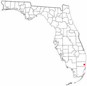
Broadview Park is a census-designated place (CDP) in Broward County, Florida, United States. The population was 7,125 at the 2010 census.

Central Valley is a hamlet in Orange County, New York, United States. The population was 1,857 at the 2000 census, at which time it was a census-designated place. It is part of the Poughkeepsie–Newburgh–Middletown, NY Metropolitan Statistical Area as well as the larger New York–Newark–Bridgeport, NY-NJ-CT-PA Combined Statistical Area.

Highland Mills is a hamlet and former census-designated place (CDP) in Orange County, New York, United States. The population was 3,468 at the 2000 census. It is part of the Poughkeepsie–Newburgh–Middletown, NY Metropolitan Statistical Area as well as the larger New York–Newark–Bridgeport, NY-NJ-CT-PA Combined Statistical Area.

<span class="mw-page-title-main">Mechanicstown, New York</span> CDP in New York, United States

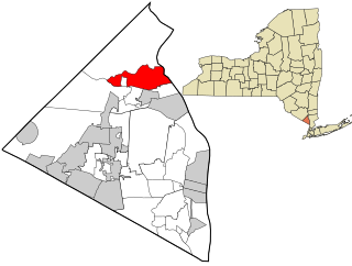
Mechanicstown is a hamlet in Orange County, New York, United States. The population was 8,065 at the 2020 census. It is part of the Poughkeepsie–Newburgh–Middletown, NY Metropolitan Statistical Area as well as the larger New York–Newark–Bridgeport, NY-NJ-CT-PA Combined Statistical Area.

<span class="mw-page-title-main">Scotchtown, New York</span> Hamlet and CDP in New York, United States

Scotchtown is a hamlet in the Town of Wallkill, in Orange County, New York, United States. The population was 10,578 at the 2020 census. It has the ZIP Code 10941. The hamlet is located east of the City of Middletown. It is part of the Poughkeepsie–Newburgh–Middletown, NY Metropolitan Statistical Area as well as the larger New York–Newark–Bridgeport, NY-NJ-CT-PA Combined Statistical Area.

<span class="mw-page-title-main">Washington Heights, New York</span> CDP in New York, United States

Washington Heights is a census-designated place (CDP) in Orange County, New York, United States. The population was 2,205 at the 2020 census.

<span class="mw-page-title-main">Hillcrest, Rockland County, New York</span> Census-designated place in New York, United States

Hillcrest is a hamlet incorporated in 1893 and census-designated place, in the town of Ramapo, Rockland County, New York, United States. It is located north of Spring Valley, east of Viola, south of New Square and New Hempstead, and west of New City. The population was 8,164 at the 2020 census.

<span class="mw-page-title-main">Mount Ivy, New York</span> Census-designated place in New York, United States

Mount Ivy is a hamlet and census-designated place in the Town of Haverstraw, in Rockland County, New York, United States. It is located north of New City, east of Pomona, south of Thiells, and west of Garnerville. The population was 6,878 at the 2010 census.

<span class="mw-page-title-main">Nanuet, New York</span> Census-designated place in New York, United States

Nanuet is a hamlet and census-designated place in the town of Clarkstown, Rockland County, New York, United States. The third largest hamlet in Clarkstown, it is located north of Pearl River, south of New City, east of Spring Valley, and west of West Nyack. It is located midway between Manhattan and Bear Mountain, 19 miles (31 km) north and south of each respectively; and 2 miles (3 km) north of the New Jersey border. It has one of three Rockland County stations on New Jersey Transit's Pascack Valley Line. The population of Nanuet was 17,882 at the 2010 census.

<span class="mw-page-title-main">New Hempstead, New York</span> Village in New York, United States

New Hempstead is a village in the town of Ramapo, Rockland County, New York, United States. It is located north of New Square, east of Wesley Hills, south of Pomona, and west of New City. The population was 5,132 at the 2010 census. Residents utilize the Spring Valley and New City post offices.

<span class="mw-page-title-main">Pomona, New York</span> Village in New York, United States

Pomona is a village partly in the town of Ramapo and partly in the town of Haverstraw in Rockland County, New York, United States. It is located north of New Hempstead, east of Harriman State Park, north of Monsey and west of Mount Ivy. According to the 2020 Census, the population was 3,824, a 23 percent increase from the 2010 figure of 3,103.

<span class="mw-page-title-main">Viola, New York</span> Census-designated place in New York, United States

Viola is a hamlet and census-designated place in the town of Ramapo, Rockland County, New York, United States. It is located north of Airmont, east of Montebello, south of Wesley Hills, and west of Hillcrest. The population was 6,868 at the 2010 census.

<span class="mw-page-title-main">Wesley Hills, New York</span> Village in New York, United States

Wesley Hills is a village in the town of Ramapo, Rockland County, New York, United States. It is located north of Viola, east of Harriman State Park, south of Pomona, and west of New Hempstead. The population was 5,628 at the 2010 census.

<span class="mw-page-title-main">West Haverstraw, New York</span> Village in New York, United States

West Haverstraw is a village incorporated in 1883 in the town of Haverstraw, Rockland County, New York, United States. It is located northwest of Haverstraw village, east of Thiells, south of the hamlet of Stony Point, and west of the Hudson River. The population was 10,165 at the 2010 census. The majority of the hamlet of Garnerville is contained in the village of West Haverstraw.

<span class="mw-page-title-main">Shokan, New York</span> CDP in New York, United States

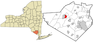
Shokan is a hamlet located in the town of Olive in Ulster County, New York, United States, within the Catskill Park. The population was 1,183 at the 2010 census.

<span class="mw-page-title-main">Walker Valley, New York</span> CDP in New York, United States

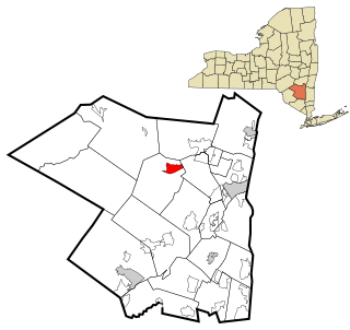
Walker Valley is a hamlet located in the western part of the Town of Shawangunk in Ulster County, New York, United States, generally thought of as coterminous with the 12588 ZIP code. The population was 853 at the 2010 census.

<span class="mw-page-title-main">Lake Ripley, Wisconsin</span> Census-designated place in Wisconsin, United States

Lake Ripley is a census-designated place (CDP), in the town of Oakland, Jefferson County, Wisconsin, United States. The population was 1,911 at the 2020 census.

<span class="mw-page-title-main">Haverstraw, New York</span> Town in New York, United States

Haverstraw is a town in Rockland County, New York, United States, located north of the Town of Clarkstown and the Town of Ramapo; east of Orange County; south of the Town of Stony Point; and west of the Hudson River. The town runs from the west to the east border of the county in its northern section. The population was 39,087 at the 2020 census.

<span class="mw-page-title-main">Stony Point (CDP), New York</span> Census-designated place in New York, United States

Stony Point is a hamlet and census-designated place in the town of Stony Point, Rockland County, New York, United States. It is located north of West Haverstraw, east of Harriman State Park, south of Tomkins Cove, and west of the Hudson River. The population was 12,147 at the 2010 census.

<span class="mw-page-title-main">Plattekill (CDP), New York</span> CDP in New York, United States

Plattekill is a hamlet in Ulster County, New York, United States. The population was 1,260 at the 2010 census. The community, as is the town, is named after a local stream, the Platte Kill.

References

  1. "ArcGIS REST Services Directory". United States Census Bureau. Retrieved September 20, 2022.
  2. "Profile of General Population and Housing Characteristics: 2010 Demographic Profile Data (DP-1): Thiells CDP, New York". United States Census Bureau . Retrieved February 9, 2012.
  3. "US Gazetteer files: 2010, 2000, and 1990". United States Census Bureau. 2011-02-12. Retrieved 2011-04-23.
  4. "Census of Population and Housing". Census.gov. Retrieved June 4, 2016.
  5. "U.S. Census website". United States Census Bureau . Retrieved 2008-01-31.
  6. Paul Piperato of Thiells, New York