
Rockland County is the second-southernmost county on the west side of the Hudson River in the U.S. state of New York, after Richmond County. It is part of the New York metropolitan area. As of the 2020 U.S. census, the county's population is 338,329, making it the state's third-most densely populated county outside New York City after Nassau and neighboring Westchester Counties. The county seat and largest hamlet is New City. Rockland County is accessible via the New York State Thruway, which crosses the Hudson to Westchester at the Tappan Zee Bridge ten exits up from the NYC border, as well as the Palisades Parkway five exits up from the George Washington Bridge. The county's name derives from "rocky land", as the area has been aptly described, largely due to the Hudson River Palisades. The county is part of the Hudson Valley region of the state.
Bardonia is a hamlet and census-designated place in the town of Clarkstown, Rockland County, New York, United States. It is located northeast of Nanuet, northwest of West Nyack, south of New City, and west of Valley Cottage. The population was 4,108 at the 2010 census.

Blauvelt is a hamlet, about 20 miles northwest of New York City. It was a census-designated place, formerly known as Greenbush and then Blauveltville, in the town of Orangetown, Rockland County, New York, United States. It is located north of Tappan, east of Nauraushaun and Pearl River, south of Central Nyack, and west of Orangeburg. As of the 2010 census, the CDP had a population of 5,689.

Clarkstown is a town in Rockland County, New York, United States. The town is on the eastern border of the county, located north of the town of Orangetown, east of the town of Ramapo, south of the town of Haverstraw, and west of the Hudson River. As of the 2020 census, the town had a total population of 86,855. The hamlet of New City, the county seat of Rockland County, is also the seat of town government and of the Clarkstown Police Department, the county sheriff's office, and the county correctional facility. New City makes up about 41.47% of the town's population.
Grand View-on-Hudson is a village incorporated in 1918 in the town of Orangetown in Rockland County, New York, United States. It is located north of Piermont, east of Orangeburg, south of South Nyack, and west of the Hudson River. The population was 285 at the 2010 census. The name is derived from the scenic view from its location.

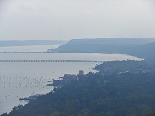
Nyack is a village located primarily in the town of Orangetown in Rockland County, New York, United States. Incorporated in 1872, it retains a very small western section in Clarkstown. The village had a population of 7,265 as of the 2020 census. It is a suburb of New York City lying approximately 15 miles (24 km) north of the Manhattan boundary near the west bank of the Hudson River, situated north of South Nyack, east of Central Nyack, south of Upper Nyack, and southeast of Valley Cottage.
Orangetown is a town in Rockland County, New York, United States, located in the southeastern part of the county. It is northwest of New York City, north of New Jersey, east of the town of Ramapo, south of the town of Clarkstown, and west of the Hudson River. The population was 48,655 at the 2020 census.

Pearl River is a hamlet and census-designated place in the town of Orangetown, Rockland County, New York, United States. It is east of Chestnut Ridge, south of Nanuet, west of Blauvelt, New York, and north of Montvale and Old Tappan, New Jersey. The population was 15,876 at the 2010 census.

Piermont is a village incorporated in 1847 in Rockland County, New York, United States. Piermont is in the town of Orangetown, located north of the hamlet of Palisades, east of Sparkill, and south of Grand View-on-Hudson, on the west bank of the Hudson River. The population was 2,517 at the 2020 census. Woody Allen set The Purple Rose of Cairo (1984) in Piermont.

South Nyack is a hamlet and census-designated place in the town of Orangetown in Rockland County, New York, United States. It is located north of Grand View-on-Hudson, northeast of Orangeburg, east of Blauvelt State Park, south of Nyack and west of the Hudson River. The hamlet is the western terminus of the Tappan Zee Bridge. Its population was 3,510 at the 2010 census. The hamlet was formerly incorporated as a village from 1878 until 2022.

Tappan is a hamlet and census-designated place in the town of Orangetown, Rockland County, New York. It is located northwest of Alpine, New Jersey, north of Northvale, New Jersey and Rockleigh, New Jersey, northeast of Old Tappan, New Jersey, east/southeast of Nauraushaun and Pearl River, south of Orangeburg, southwest of Sparkill, and west of Palisades; Tappan shares a border with each. The population was 6,673, according to the 2020 census.

West Haverstraw is a village incorporated in 1883 in the town of Haverstraw, Rockland County, New York, United States. It is located northwest of Haverstraw village, east of Thiells, south of the hamlet of Stony Point, and west of the Hudson River. The population was 10,165 at the 2010 census. The majority of the hamlet of Garnerville is contained in the village of West Haverstraw.

Greenburgh is a town in western Westchester County, New York. The population was 95,397 at the time of the 2020 census.

Palisades, formerly known as Sneden's Landing, is a hamlet in the Town of Orangetown in Rockland County, New York. It is located north of Rockleigh and Alpine, New Jersey; east of Tappan; south of Sparkill; and west of the Hudson River.

Camp Shanks was a United States Army installation in the Orangetown, New York area. Named after Major General David C. Shanks, it was situated near the juncture of the Erie Railroad and the Hudson River. The camp was the largest U.S. Army embarkation camp used during World War II.

Sparkill, formerly known as Tappan Sloat, is a suburban hamlet and census-designated place in the Town of Orangetown, Rockland County, New York, United States located north of Palisades; east of Tappan; south of Piermont and west of the Hudson River. As of the 2010 census, the CDP had a population of 1,565. The hamlet is home to St. Thomas Aquinas College and the Dominican Sisters of Sparkill.

New York State Route 340 (NY 340) is a 3.10-mile (4.99 km) state highway in southeastern Rockland County, New York, in the United States. Though it is signed as an east–west route, it actually follows a north–south alignment. The southern terminus of the route is at the New Jersey state line in Palisades, where it becomes County Route 501 (CR 501). The northern terminus is at an intersection with NY 303 in Orangeburg; however, according to the New York State Department of Transportation (NYSDOT), the route continued for another 0.07 miles (0.11 km) to the northwest of NY 303 until by 2017. NY 340 was assigned to part of its modern routing in the early 1930s and extended to its current length in the early 1940s.

New York State Route 303 (NY 303) is a north–south state highway in eastern Rockland County, New York, in the United States. It begins at the New Jersey state line in the hamlet of Tappan and runs generally northward for 10.92 miles (17.57 km) to an intersection with U.S. Route 9W (US 9W) in Clarkstown. The route has connections to the Palisades Interstate Parkway and the New York State Thruway, the latter carrying Interstate 87 (I-87) and I-287. NY 303 was assigned as part of the 1930 renumbering of state highways in New York, and only minor realignments have occurred since that time.
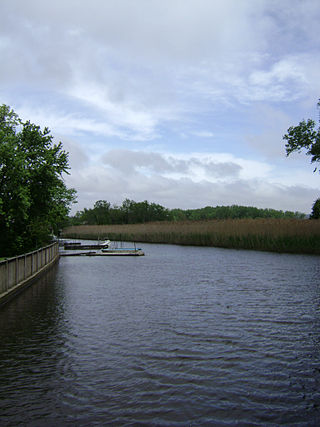
Sparkill Creek, is a tributary of the Hudson River in Rockland County, New York and Bergen County, New Jersey in the United States. It flows through the Sparkill Gap in the Hudson Palisades, which was created by a fault line which provided the only sea-level break in the Palisades.

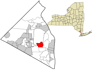
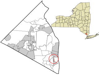
The Rockland Psychiatric Center, originally Rockland State Hospital, in Orangeburg, New York is a psychiatric facility for adults operated by the New York State Office of Mental Health. It offers in-patient and transitional treatment for adults, as well as research facilities. There are 13 outpatient facilities and 11 residential programs in the four surrounding counties. The facility shares space with the co-located Nathan Kline Institute. The inpatient treatment center has 410 beds. The current hospital replaces an older hospital on the same 615-acre (249 ha) site.


